


Variably cloudy skies with isolated to scattered showers and thunderstorms are forecast daily this week as a tropical wave and a low-level trough interact with the Intertropical Convergence Zone (ITCZ).
What you need to know
— Rainfall: Over the next five days, through Saturday night, overall rainfall accumulations across the country are forecast to range between 25 and 75 millimeters, with five-day totals between 75 and 150 millimeters favoring southern and eastern halves of Trinidad. In highly isolated areas, daily rainfall totals exceeding 25 to 50 millimeters are likely, mainly Tuesday through Thursday.
— Saharan Dust: Through Wednesday afternoon, mild to moderate dust levels are forecast, with moderate to high dust levels through the remainder of the forecast period.
— Hazards: Daily through Friday, locally heavy rainfall is likely in heavy showers/thunderstorms, producing localized street/flash flooding and accompanied by gusty winds. From Wednesday, gusty winds are likely to exceed 55 KM/H. Frequent lightning is possible in thunderstorm activity. As the week progresses, with increasing soil saturation, the risk of landslides is likely to increase and particularly in southern and eastern areas, river levels will need to be closely monitored.
— Marine: Generally moderate seas are forecast over the next five days.
Latest Alerts

High Wind Alert Remains In Effect For T&T
Trinidad and Tobago is NOT under any tropical storm or hurricane threat, watch, or warning at this time.
The Forecast
Monday Night
Monday NightTuesday
TuesdayWednesday
WednesdayThursday
ThursdayFriday
FridaySaturday
SaturdayMarine Forecast

Seas Forecast: Long-Period Swells To Return Next Week
Temperatures
Tuesday
Low: 23-26°C
High: 31-33°C
Wednesday
Low: 23-25°C
High: 29-31°C
Thursday
Low: 23-25°C
High: 31-33°C
Friday
Low: 24-26°C
High: 31-33°C
Saturday
Low: 25-27°C
High: 32-34°C
Forecast Impacts
Flooding
Over the next five days, through Saturday night, overall rainfall accumulations across the country are forecast to range between 25 and 75 millimeters, with five-day totals between 75 and 150 millimeters favoring southern and eastern halves of Trinidad. In highly isolated areas, daily rainfall totals exceeding 25 to 50 millimeters are likely.
Street & Flash Flooding
Street & Flash FloodingRiverine Flooding
Riverine FloodingForecast Rainfall Totals
- Tuesday: Between 10 and 25 millimeters of rainfall across both islands, with isolated totals between 25 and 50 millimeters, particularly in heavy thunderstorm/shower activity.
- Wednesday: Between 5 and 15 millimeters of rainfall across both islands, with isolated totals across up to 25 millimeters favoring coastal areas of southern, western, and eastern Trinidad.
- Thursday: Between 5 and 15 millimeters of rainfall across both islands. Across eastern and southern halves of Trinidad, as well as western coastal Trinidad, between 25 and 50 millimeters are possible, with higher totals in heavy showers/thunderstorms.
- Friday: Less than 10 millimeters of rainfall across both islands, with isolated totals up to 25 millimeters favoring southwestern coastal areas of Trinidad, as well as eastern Trinidad.
- Saturday: Less than 5 millimeters of rainfall across the country, with isolated higher totals favoring eastern and northern Trinidad, and Tobago.

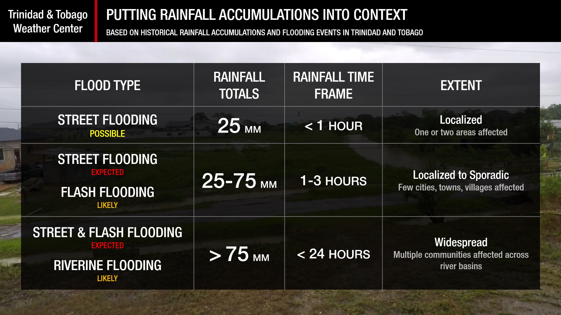
Understanding Rainfall Accumulations
Putting the rainfall forecast into context, rainfall rates in excess of 50 millimeters per hour or areas that receive in excess of 25 millimeters within an hour tend to trigger street flooding across the country or flash flooding in northern Trinidad. For riverine flooding to occur, a large area of the country (not just in highly localized areas of western coastal Trinidad) would have to record upwards of 75 millimeters within 24 hours, and rainfall would have to fall across major rivers’ catchment areas.
Strong Thunderstorms
Strong ThunderstormsWhat is a strong or severe thunderstorm?
Given how rare these types of thunderstorms are in our region – we classify a severe or strong thunderstorm as one that produces any of the following:
- Damaging wind gusts exceeding 55 KM/H;
- Frequent lightning (more than 30 cloud-to-ground strikes within a 10-minute period);
- Hail (of any size);
- Rainfall of more than 50 millimeters or more within an hour or exceeding 75 millimeters or more within three hours;
- The sighting of a funnel cloud or touchdown of a waterspout/tornado associated with the thunderstorm.
Gusty Winds
Gusty WindsWith winds gusting above 50 KM/H, whole trees can be in motion, with larger trees and weaker branches falling. Light outdoor objects can topple or become airborne, such as garbage cans, loose galvanize, construction material, and outdoor furniture. Tents may also jump. Due to saturated soils, with strong winds, trees may fall easier, particularly along the Northern Range.
Other Hazards
Saharan Dust Forecast

Next Saharan Dust Surge Forecast By Mid-Next Week
Why I May Not/Will Not See Rainfall?
A frequent complaint is the forecast is wrong because I didn’t experience any rainfall. Scattered showers mean that you, individually, may experience some showers intermittently throughout the day, and there is a higher chance for this activity than isolated activity. Widespread showers mean that nearly all persons and areas may experience rainfall.
On Tuesday through Thursday, isolated to scattered rainfall is likely, with isolated rainfall possible on Friday and Saturday.

Forecast Discussion
A weak low-level trough embedded within the Intertropical Convergence Zone (ITCZ) is forecast to move across T&T and the Windward Islands tonight (Monday night) through Tuesday, bringing sufficient instability for scattered showers and isolated thunderstorms through Tuesday.
Then, on Wednesday, low-level winds are forecast to increase, with enhanced convergence trailing the low-level trough, as well as the ITCZ remaining across T&T. All of these features will lead to scattered showers and thunderstorms across both islands but favoring Trinidad.
Generally, between Tuesday and Thursday (outside of Wednesday afternoon through the pre-dawn hours of Thursday morning), relative humidities are forecast to remain above 70% with low-, mid-, and upper-levels becoming increasingly moist; wind shear is forecast to be light to moderate, up to 20 knots from the west to northwest, and increasing instability will lead to periods of heavy rainfall during this three-day period.
Conditions are set to settle briefly into Wednesday evening as a dry pocket of air and a short-lived ridge pattern ahead of Tropical Wave 24 move across the region. By early Thursday morning, the weak tropical wave moves across the Lesser Antilles but interacts with the ITCZ still across Trinidad and Tobago, leading to scattered showers and thunderstorms once more due to a surface-to-mid-level confluent pattern and deep-layered moisture.
While dust models also show a moderate to high concentration surge of Saharan Dust moving in by Wednesday evening and Thursday morning, forecast models continue to show an amply moist atmosphere from late Thursday morning through the afternoon.
MLCAPE values are forecast to be between 1000 J/KG and 1500 J/KG, with relative humidity above 70% and high precipitable water above 2 inches—all ingredients for locally heavy rainfall during Thursday’s late morning into the afternoon. A low-level jet is also forecast to develop, with southeasterly to easterly winds between 25 and 35 knots, advecting moisture across the region and feeding into shower and thunderstorm activity.
With the ITCZ around, it is important to remember that peak activity associated with this area of convergence typically happens during the early morning and early afternoon hours. Heavy overnight rainfall is possible, and those living in flood-prone areas should be ready to act in the event persistent heavy rainfall materializes, leading to street, flash, and even riverine flooding.
With soils already relatively saturated, the risk of landslides in elevated areas and trees falling in gusty winds will increase throughout the week. If you live in a flood-prone area, particularly with the threat of heavy overnight rainfall, be prepared to act quickly if flooding materializes—with or without an official alert/watch/warning in place.
By Friday, the ITCZ is forecast to shift southward as a ridge rebuilds by the afternoon. As a result, rainfall is expected during the first half of the day through the early afternoon, but conditions become increasingly dry and hazy.
By Saturday, the atmosphere is forecast to continue becoming increasingly dry as a high-pressure ridge rebuilds and winds at the low levels remain elevated.


