


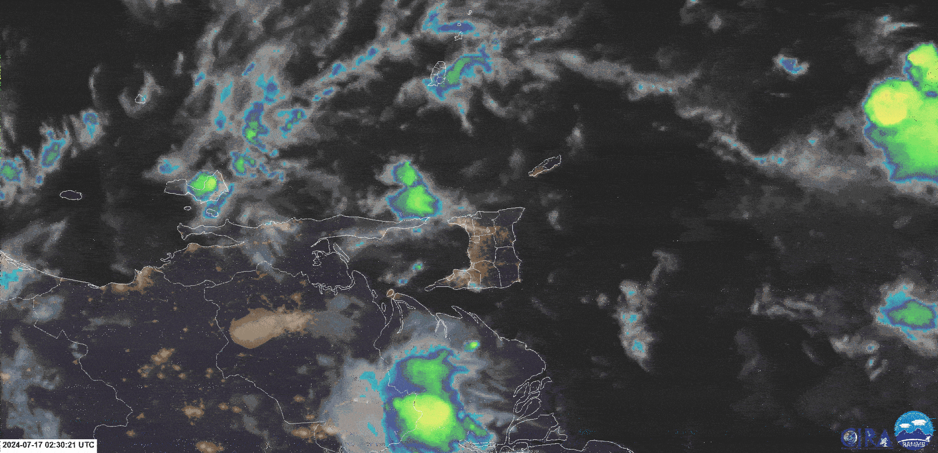
The Trinidad and Tobago Meteorological Service has issued an Adverse Weather Alert. According to TTMS forecasters, “A band of convergence to the east of Tobago is expected to be enhanced by favorable atmospheric features and generate broad areas of moderate to heavy showers as well as occasional thunderstorms.”
Meanwhile, parts of southern Trinidad, including Barrackpore, Morgua, and Penal, remain underwater following heavy overnight rainfall, with the South Oropouche River flooding low-lying areas.
What you need to know
— Rainfall: Over the next 24 hours, forecast models show additional rainfall accumulations across Trinidad and Tobago as high as 30 millimeters, but high-resolution modeling shows localized totals across Central Trinidad (outside of the alert area) and northern Trinidad receiving as high as 100 millimeters of rainfall. Generally, northern areas of Trinidad are forecast to record the highest rainfall accumulations, with isolated high totals across western Trinidad.
— Hazards: The main hazards will originate from heavy showers and thunderstorms, which will produce cloud-to-ground lightning, gusty winds up to 50 KM/H), and periods of heavy/violent rainfall, which can trigger street/flash flooding. Due to saturated soils, landslides are likely in elevated areas, particularly along the Northern Range and windward slopes of Tobago. Seas are forecast to become locally agitated during heavy showers or thunderstorms.
Latest Alerts

Adverse Weather Alert Discontinued. Showers, Thunderstorms Still In The Forecast
Trinidad and Tobago is NOT under any tropical storm or hurricane threat, watch, or warning at this time.
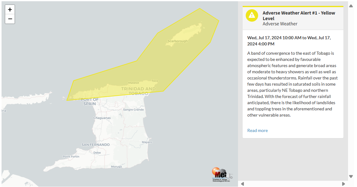
The Adverse Weather Alert
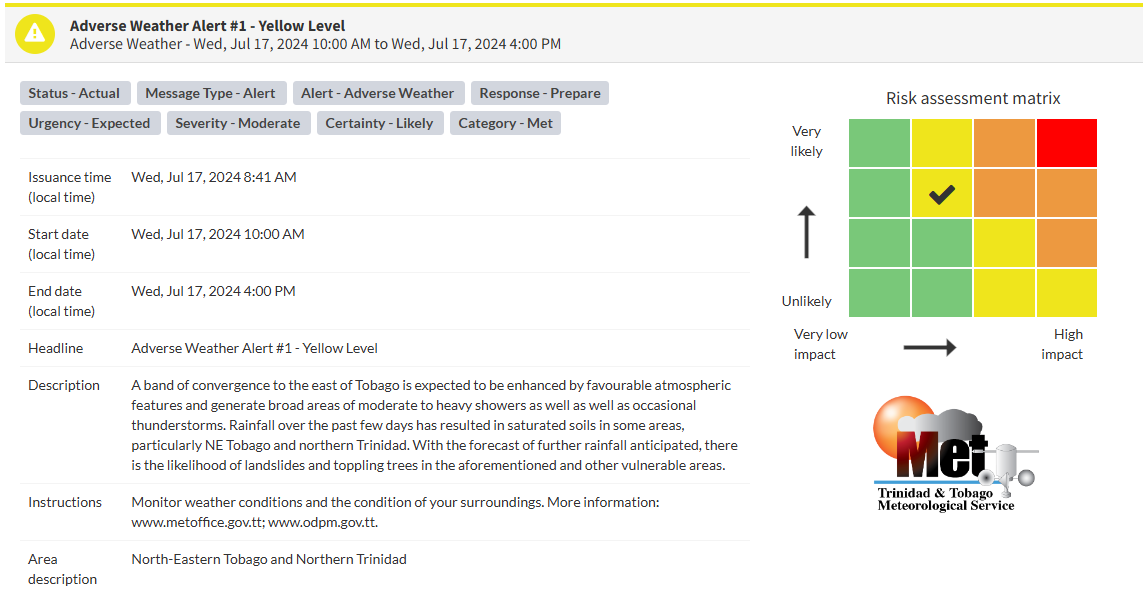
The Trinidad and Tobago Meteorological Service issued an Adverse Weather Alert (Yellow Level) on Wednesday at 8:41 AM. The alert goes into effect for northern Trinidad and Tobago at 10:00 AM Wednesday, July 17th, 2024, and remains in effect until 4:00 PM today.
As mentioned earlier, the forecast of inclement weather is due to back-to-back tropical waves and the Intertropical Convergence Zone across T&T.
This “alert” status considers the possibility of the event occurring. This adverse weather event is likely to have the following impacts, according to the TTMS:
- A band of convergence to the east of Tobago is expected to be enhanced by favorable atmospheric features and generate broad areas of moderate to heavy showers as well as occasional thunderstorms.
- Rainfall over the past few days has saturated soils in some areas, particularly in NE Tobago and northern Trinidad.
- With further rainfall anticipated, landslides and toppling trees are likely in the aforementioned and other vulnerable areas.

The alert’s color indicates the severity of the event and the probability of its occurrence. Currently, the alert level is Yellow. This means that the hazards are likely, and the severity of the impacts is moderate for this particular alert. You should be aware of the hazards in your area associated mainly with street/flash flooding, landslides, gusty winds up to 50 KM/H possible falling trees, and agitated seas.
A moderate Adverse Weather Alert can result in possible injuries and behavioral changes are required to ensure safety. Minor damage to property may also occur, temporarily disrupting income-earning activities and affecting a couple of communities.
The Met Office is advising the public to monitor weather conditions and the condition of your surroundings.


