Originally published on March 27th, 2022. Updated on July 11th, 2024.
For years, any Trinbagonians with internet access could look at incoming weather in near real-time before even looking out the window. To some extent, we still can. Satellites have made significant strides worldwide in recent history, updating every few minutes and allowing anyone with an internet connection to see weather systems near them. But Trinidad and Tobago had another tool in our arsenal: a Doppler weather radar.
This specialized, expensive equipment is predominantly used to detect the motion and intensity of rain droplets. These two critical pieces of data allow meteorologists to determine the structure of showers or thunderstorms and their potential to cause hazardous weather. With strides in technology, radars can detect strong winds, whether thunderstorms are producing rain or hail, how tall clouds extend into the sky, take vertical cross-sections of showers or thunderstorms, and even calculate how much rain has fallen and accumulated.
Since February 2020, Trinidad and Tobago’s Doppler radar has been out of service. The Trinidad and Tobago Meteorological Service brought it back to service in July 2024 after four years and four months, and a new, smaller radar has joined T&T’s radar coverage. However, radar data and images populate intermittently on the TTMS’ website and mobile app, with continuous data remaining limited to forecasters and not publicly available at the time of this article.
T&T’s Weather Radar History
In 1967, the first Doppler weather radar was installed at Crown Point, Tobago, through the partnership of the World Meteorological Organization (WMO) and the United Nations Developmental Program. This RC-32B radar, manufactured by Mitsubishi, became the longest-serving radar in the English-speaking Caribbean of its type, according to Christopher St. Clair, a Meteorological Supervisor and Officer-in-Charge of the Meteorological Services in Tobago. This specific radar model was installed in Cuba in the early 1970s and is still in use today by the Cuban Meteorological Services after modernization in 2006 and again in 2021.
By the turn of the 21st century, the Tobago radar was no longer operational. However, talks began in 1994 through an initiative between the WMO and the Caribbean Meteorological Organization (CMO) to develop the Caribbean Radar Network. This project eventually became the CARIFORUM initiative for a radar network warning system in the Caribbean. It directly led to Doppler radars being installed in T&T, Guyana, Barbados, and Belize at the cost of 13.2 million Euros.
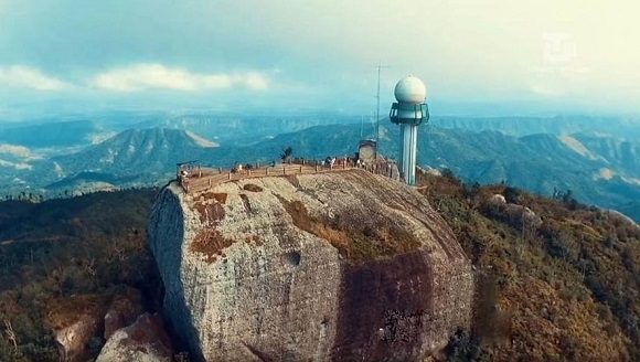
The CMO and the French Meteorological Service conducted a detailed technical study of six potential sites in Trinidad and Tobago and chose Brasso Venado on the Central Range to construct the Doppler radar.
The 20-meter reinforced concrete tower housing the radar was completed in January 2008, the radar was physically installed in March 2008, and testing began in early April 2008. However, by July of that year, testing ceased due to the failure of a Pulse Transformer, leading to a months-long delay in commissioning. By November, Trinidad and Tobago now had a powerful, high-precision METEOR 600 S-band Doppler radar.
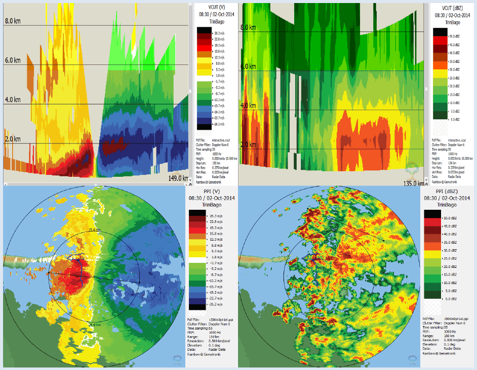
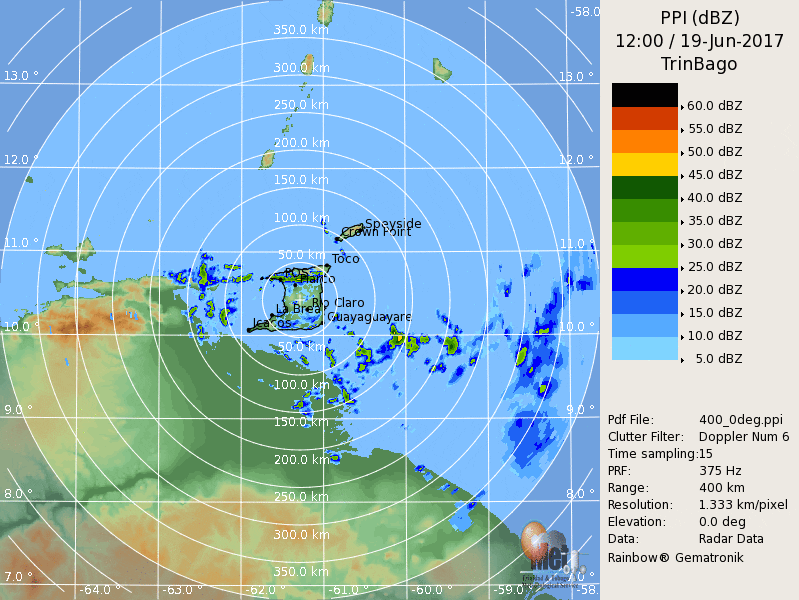
The Brasso radar was capable of detecting surface rainfall intensity, locations of showers (reflectivity) and thunderstorms, cloud heights, and horizontal and vertical winds (wind velocity). Meteorologists were also able to create cross-sections to see further atmospheric detail. The radar extended 400 kilometers away from Central Trinidad in all directions, capable of detecting rain as far north as St. Lucia and Barbados, as far west as Tortuga Island, Venezuela, and as far southeast as northeastern Guyana.
The Doppler radar ran 24/7, year-round, only down for brief routine maintenance, for nearly ten years. The Brasso radar saw tornadoes, tropical cyclones, flooding rainfall, and many other hazardous hydro-meteorological events. However, significant wear and tear persisted. Former acting Chief Climatologist at the Trinidad and Tobago Meteorological Service (TTMS), Kenneth Kerr, said during the TTMS’ 2022 World Meteorological Day webinar that even with the frequency of corrective maintenance, the wear became too much for the system.
The multi-million dollar Doppler weather radar system went down on February 12th, 2020.
“You do not find a radar sitting on a shelf”
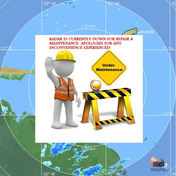
On July 11th, 2024, the first publicly available radar images hit the Trinidad and Tobago Meteorological Website after four years, four months, and 22 days since the Brasso Venado Doppler radar went out of operation. The Met Office was adamant that this prolonged outage was not a result of a lack of trying.
Kenneth Kerr, the then chief climatologist at the TTMS, speaking virtually, explained in 2022, “We have a bigger problem now because you do not find a radar sitting on a shelf like a bookbag anywhere on the globe.”
“And when you manufacture this radar, sometimes the company that manufactured the equipment is not manufacturing that particular level of radar anymore. So when you need a part, it means that they have to go and rebuild that particular part because, as I said, technology is constantly changing.”
The METEOR 600 S-band Doppler radar at Brasso Venado was manufactured by Selex-Gematronik Company of Germany and is no longer produced. The company now manufactures the 700 S-Band model. Barbados, which also had a METEOR 600 S-Band radar, recently upgraded at the cost of US$3.5 million.
According to Kerr, even the replacement parts are quite expensive. Compounding issues, “Every time we find and fix one problem, another one pops up given the complexity of it,” Kerr explained.
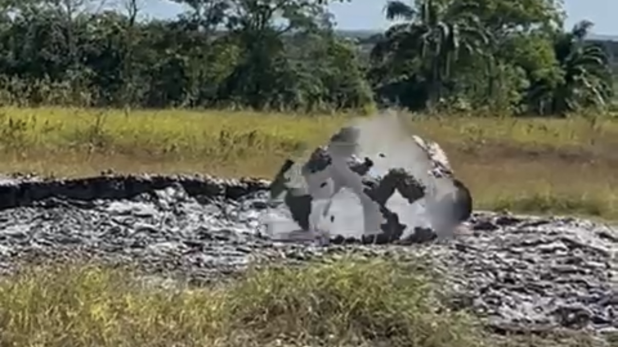
Several mechanical issues had been with the radar unit, and replacement parts to refurbish the decades-old radar had to be custom-built. The radar parts arrived in Trinidad in October 2023. For the last four years, repeated promises have been made to get the radar back up and running.
However, on July 6th, 2024, the radar was recommissioned.
Was cost also an issue?
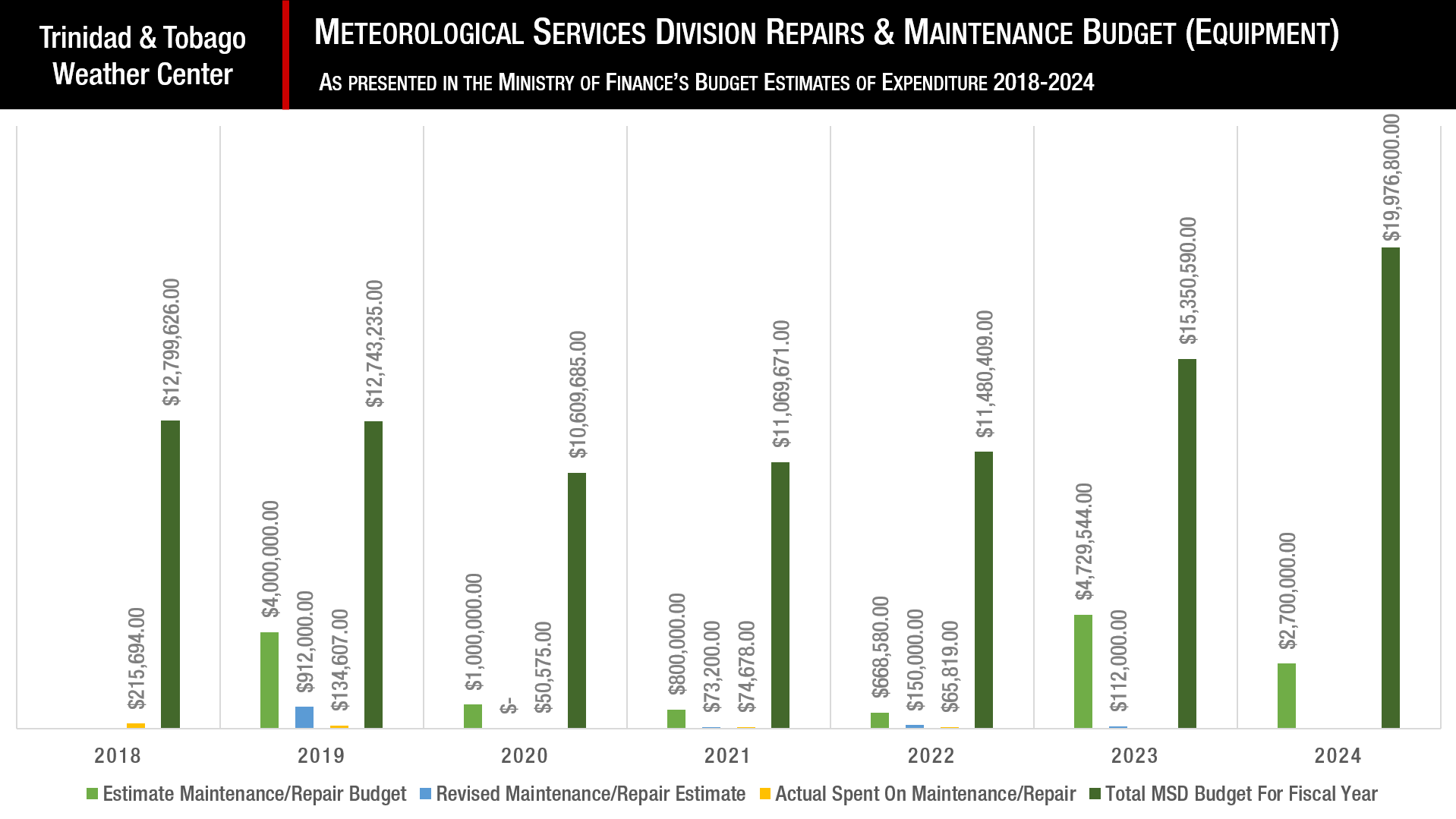
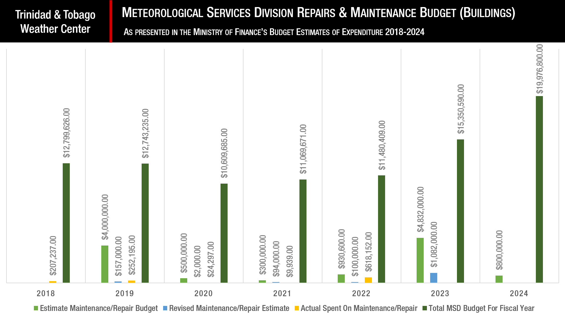
Given that the repairs to the existing radar would fall into recurrent expenditure rather than capital expenditure if the Met Office were to purchase a new radar system, we took a look at the Meteorological Services Division’s budget from 2018 through 2024.
Based on the last several budgets, the Meteorological Services Division (MSD) has spent a fraction of its annual maintenance and repair budget allocation. In fact, since 2018, and using estimates for 2023 and 2024, the MSD has spent $3.35 million on equipment repairs and approximately $2.99 million on building repairs, accounting for just over 10% of the total MSD budget for the last six years. However, repairing the radar has been a priority for both the Trinidad and Tobago Meteorological Service and its line ministry – the Ministry of Public Utilities.
Funds have been routinely allocated to the MSD in Trinidad and Tobago for upgrades. Major allocations over the last few years:
- 2024: $1 million for the IT Upgrade for the MSD.
- 2024: $2 million for the procurement of a Geostationary Operational Environment Satellite (GOES-16) Receiving System for the TTMS at Piarco.
- 2023: $1.8 million (revised estimate) for the refurbishment of the Radar Tower at Brasso Venado after an $8 million estimate.
- 2023: $1.3 million (revised estimate) for the procurement, installation, operations, and training of a Defender S850 S-Band Simultaneous Dual Polarization Radar after a $5 million estimate – which signals a new radar is coming to T&T.
Out of an $8 million allocation, $5.5 million was spent on a new HVAC system, the supply and delivery of two automated weather systems, and an upgrade of the network and computer system at the MSD building in Crown Point, Tobago. Meanwhile, in Trinidad, $5.0 million has been allocated in 2024, down from a 2023 estimate of $10 million, to the Ministry of Public Utilities to construct a new MSD building, which will house all five units of the Trinidad and Tobago Meteorological Service under one roof.
However, funds from another arm of the government, the Central Administrative Services of Tobago, have been used to provide the Trinidad and Tobago Meteorological Services in Tobago with new equipment.
Decades Later, Tobago Gets New Radar, Satellite Equipment
Through the government’s Public Sector Investment Program, TT$36.7 million has been allocated to constructing the new meteorological office at Crown Point and the procurement of meteorological equipment. The central government has invested in upgrading Tobago’s meteorological capabilities so that the Crown Point meteorological office can act as a backup to Piarco.
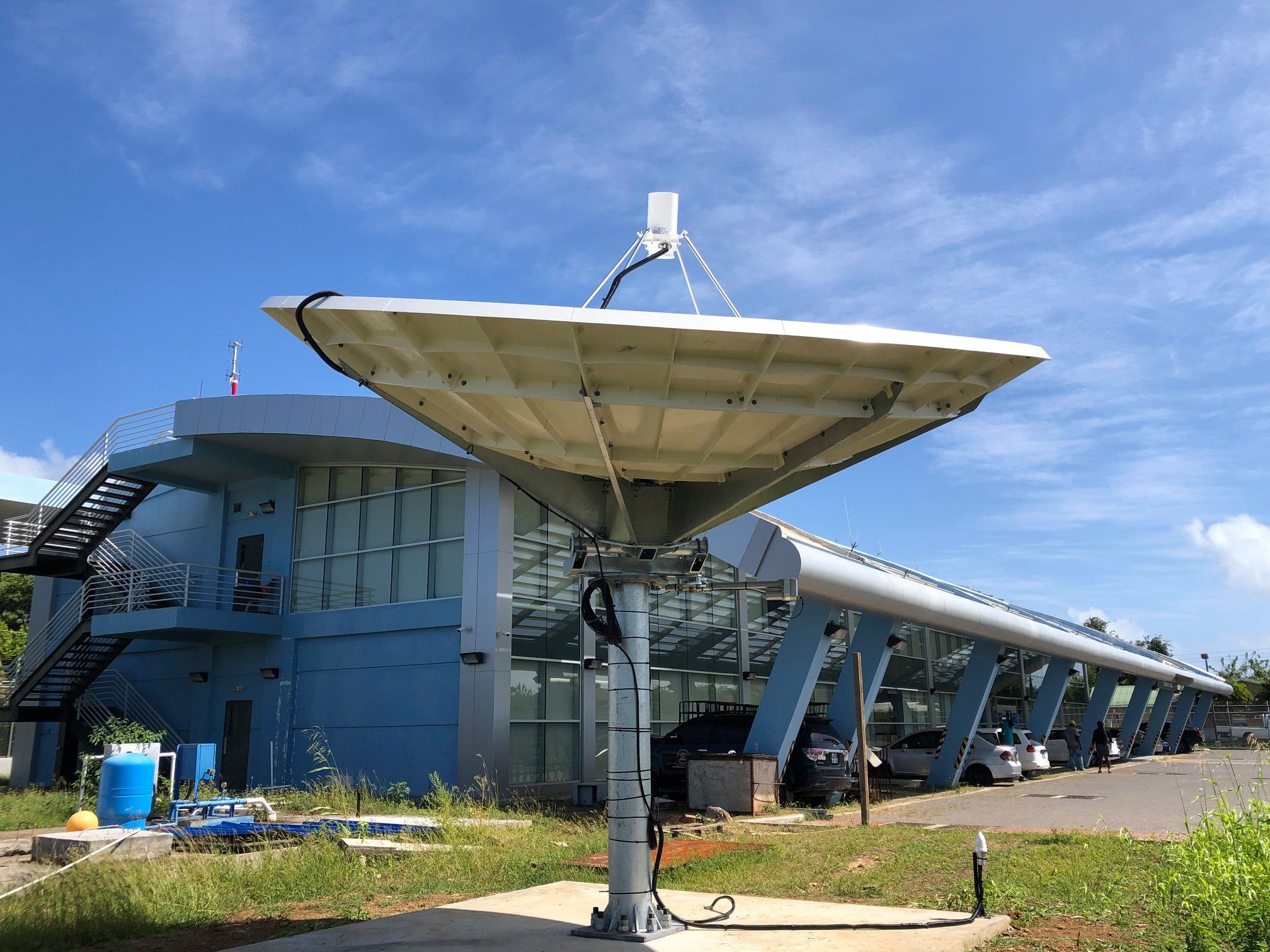
The Tobago MSD has also been allocated TT$4.6 million for the 2021/2022 fiscal year to purchase a climate management system, more automated weather stations at A.N.R Robinson International Airport in Buccoo, Tobago, and Flagstaff, as well as a voltage regulator and an ultraviolet monitoring system. The island also now has a Capella-GR GOES-16 direct receive ground station, allowing the Tobago Met Office to receive GOES-16 satellite images directly.
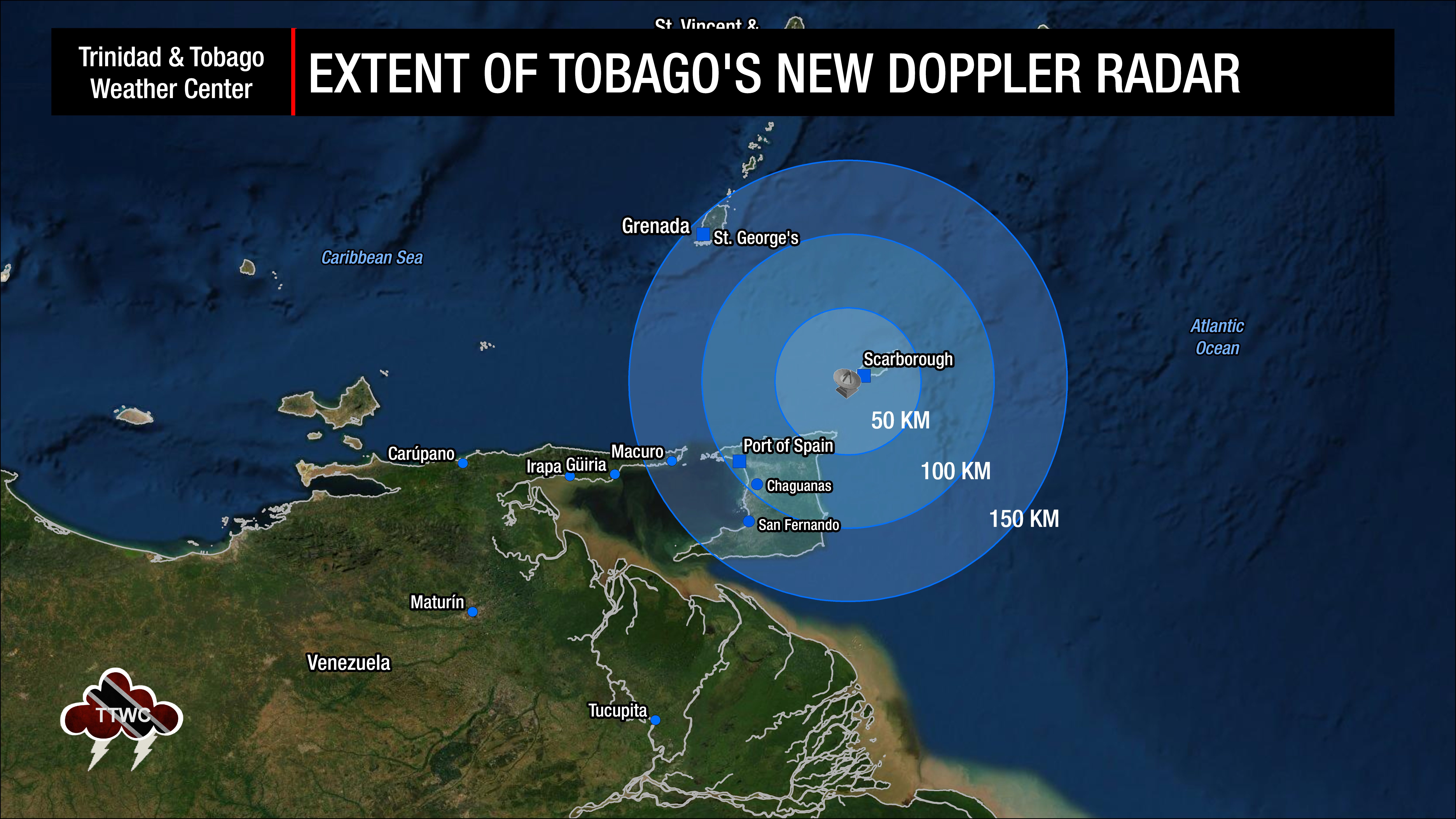
As of 2022, Tobago now has a Ranger X-5 ICAO Compliant X Band Portable Doppler Weather Radar System but a much smaller range of 150 kilometers from Crown Point. This dual-polarization radar is a marked upgrade, allowing forecasters to have more accurate estimates of precipitation, discern between rain and hail, and better detect non-meteorological hazards in the sky, such as birds or tornado debris.
According to a Caribbean Meteorological Organization report last November on the Caribbean’s radar network, irregular voltage at the Crown Point office has caused operational radar instability, including radar freezing and, at times, a complete radar shutdown. The radar router was also damaged in August 2023. The report stated that radar data were not being archived. It added that forecasters at Piarco did not have operational access to the data.
This new radar can also operate in sustained winds up to 120 KM/H, gusts to 144 KM/H, and can survive winds up to 240 KM/H. To date, the strongest winds that have impacted Tobago originated from Hurricane Flora in 1963, with maximum sustained winds at 90 knots (167 KM/H) with gusts to 110 knots (205 KM/H).
According to the Met Office, they hope to make the radar imagery available to the public via the TTMS website eventually. The Tobago Radar has been functioning for the last several months, but radar data and images populate intermittently on the TTMS’ website and mobile app, with continuous data remaining limited to forecasters and not publicly available at the time of this article.