


An active tropical wave, Tropical Wave 17/Invest 96L, is moving across the Windward Islands today, with the National Hurricane Center giving it low chances of development. However, the strongest winds and convection (showers/thunderstorms) remain north of T&T at this time, with generally light winds across Trinidad and showers affecting Tobago.
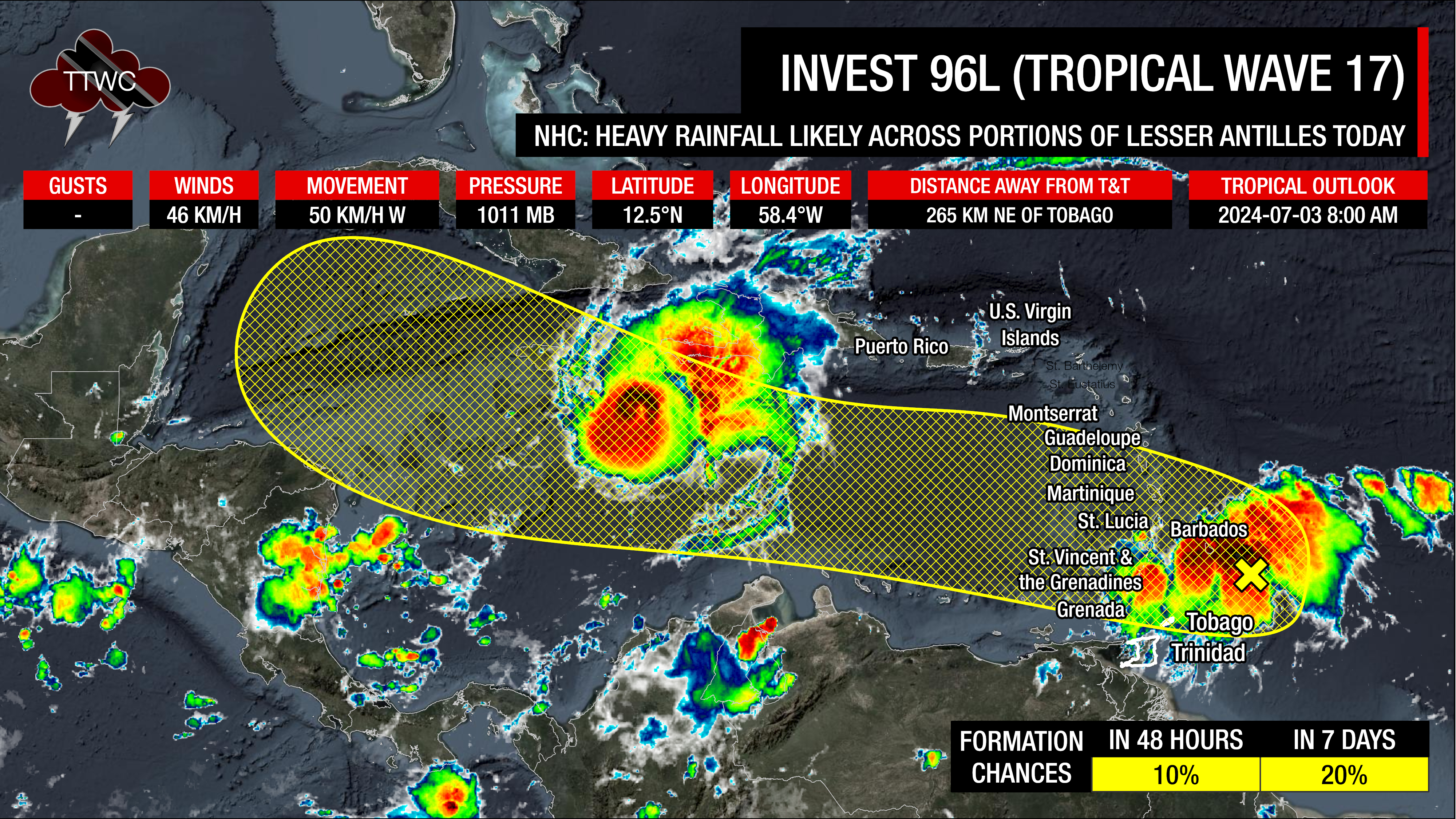
This pattern is expected to hold throughout the day, but by the late morning through the afternoon, isolated heavy showers and thunderstorms are likely to develop along the western and northern areas of Trinidad.
The Trinidad and Tobago Meteorological Service has also been issuing official statements on this system, the latest at 8:08 AM stating, “Most activity associated with AL96 is forecast to remain north of Trinidad and Tobago. However, there is a medium (40%) chance of isolated heavy showers/thunderstorms, which may be accompanied by gusty winds.”
Then, from tomorrow afternoon into the weekend, mostly dry and dusty conditions are forecast to persist, barring the odd late morning through afternoon showers or thunderstorms and the passage of low-level cloud patches.
What you need to know
— Rainfall: Over the next five days, through Sunday night, overall rainfall accumulations across the country are forecast to range from 10 to 25 millimeters, with totals up to 75 millimeters favoring eastern areas of Trinidad, as well as Tobago and localized western parts of Trinidad.
— Saharan Dust: Moderate to high concentrations of Saharan Dust are forecast across T&T from Thursday through the remainder of the forecast period.
— Hazards: Mainly on Wednesday and Sunday, in heavy showers/thunderstorms, there is the risk of gusty winds exceeding 50 KM/H, locally intense rainfall producing street/flash flooding, lightning, and mainly across Tobago, landslides in elevated areas. Due to light and variable winds on Wednesday, funnel cloud development is possible.
— Marine: Generally moderate seas are forecast over the next five days.
Latest Alerts

High Wind Alert Remains In Effect For T&T
Trinidad and Tobago is NOT under any tropical storm or hurricane threat, watch, or warning at this time.
The Forecast
Wednesday
WednesdayThursday
ThursdayFriday
FridaySaturday
SaturdaySunday
SundayMarine Forecast

Seas Forecast: Long-Period Swells To Return Next Week
Temperatures
Wednesday
Low: 24-26°C
High: 31-33°C
Thursday
Low: 24-26°C
High: 31-34°C
Friday
Low: 24-26°C
High: 31-34°C
Saturday
Low: 24-26°C
High: 31-34°C
Sunday
Low: 24-27°C
High: 30-32°C
Forecast Impacts
Flooding
FloodingForecast Rainfall Totals
- Wednesday: Across the country, at least 5 millimeters of rainfall is forecast. Across Tobago, northern and western areas of Trinidad, between 5-15 millimeters, with isolated totals likely exceeding 25 millimeters, mainly in heavy isolated thunderstorm activity.
- Thursday: Less than 5 millimeters of rainfall across the country, with isolated totals along eastern and western coastal Trinidad up to 15 millimeters.
- Friday: Less than 5 millimeters of rainfall across the country, with isolated totals along eastern and western coastal Trinidad up to 15 millimeters.
- Saturday: Less than 5 millimeters of rainfall across the country, with isolated totals across eastern Trinidad up to 15 millimeters.
- Sunday: Across the country, between 5 and 15 millimeters, with isolated totals exceeding 25 millimeters, mainly in heavy isolated thunderstorm activity, favoring Tobago, eastern and western coastal areas of Trinidad.

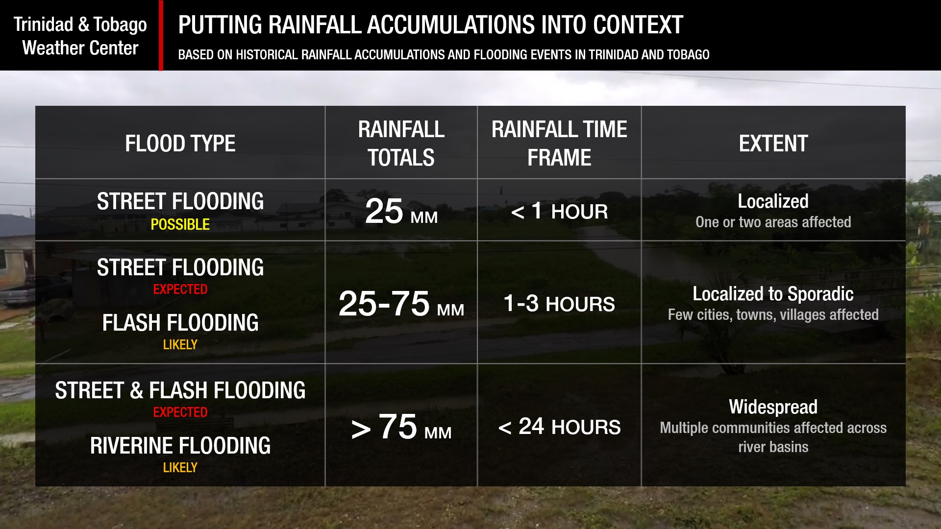
Understanding Rainfall Accumulations
Putting the rainfall forecast into context, rainfall rates in excess of 50 millimeters per hour or areas that receive in excess of 25 millimeters within an hour tend to trigger street flooding across the country or flash flooding in northern Trinidad. For riverine flooding to occur, a large area of the country (not just in highly localized areas of western coastal Trinidad) would have to record upwards of 75 millimeters within 24 hours, and rainfall would have to fall across major rivers’ catchment areas.
Strong Thunderstorms
Strong ThunderstormsWhat is a strong or severe thunderstorm?
Given how rare these types of thunderstorms are in our region – we classify a severe or strong thunderstorm as one that produces any of the following:
- Damaging wind gusts exceeding 55 KM/H;
- Frequent lightning (more than 30 cloud-to-ground strikes within a 10-minute period);
- Hail (of any size);
- Rainfall of more than 50 millimeters or more within an hour or exceeding 75 millimeters or more within three hours;
- The sighting of a funnel cloud or touchdown of a waterspout/tornado associated with the thunderstorm.
Gusty Winds
Gusty WindsWith winds gusting to 50 KM/H and occasionally above, whole trees can be in motion, with larger trees and weaker branches falling. Light outdoor objects can topple or become airborne, such as garbage cans, loose galvanize, construction material, and outdoor furniture. Tents may also jump.
Other Hazards
Saharan Dust Forecast

Next Saharan Dust Surge Forecast By Mid-Next Week
Why I May Not/Will Not See Rainfall?
A frequent complaint is the forecast is wrong because I didn’t experience any rainfall. Scattered showers mean that you, individually, may experience some showers intermittently throughout the day, and there is a higher chance for this activity than isolated activity. Widespread showers mean that nearly all persons and areas may experience rainfall.
On Sunday, scattered rainfall is forecast, with all other days experiencing isolated rainfall.

Forecast Discussion
Trinidad and Tobago’s period of active weather is nearly over, as Saharan Dust is set to keep the tropics east of T&T relatively quiet for the next 10 days after Wednesday.
A strong tropical wave, Tropical Wave 17/Invest 96L, is moving across the Windwards on Wednesday, producing widespread cloudiness, scattered showers, and thunderstorms, mainly north of Trinidad. Strong wind gusts have been observed at the Grantley Adams International Airport in Barbados, with sustained winds of 52 KM/H and gusts of 87 KM/H. This disturbance is producing heavy rainfall and gusts across areas ravaged by Hurricane Beryl earlier this week.
While showers have affected Tobago since the early morning, most of the active weather will remain north of the country. However, winds remain light across Trinidad, and combined with daytime heating, sea breeze convergence, and winds from the south/southeast, these features and orographic enhancement of shower/thunderstorm activity are likely to develop and enhance shower/thunderstorms later this morning through the afternoon, favoring western and northern Trinidad. There is ample low-level convergence and upper-level divergence to support shower/thunderstorm development under a fairly light wind-shear environment. These light winds on Wednesday, coupled with veering winds through the atmosphere and daytime heating, could also lead to the development of a funnel cloud favoring western areas of Trinidad.
As this disturbance moves west, a ridge of high pressure, accompanied by a low-level jet and a surge of Saharan Dust, is forecast to move in across the country. While generally dry conditions are forecast from Thursday through Saturday, daytime heating, moisture at the lowest levels of the atmosphere moving from the southeast, coupled with pockets of low-level convergence/confluence bringing in passing showers, gusty winds at low levels of the atmosphere may make it to the surface in those passing showers or even be enhanced to develop into a heavy shower/shortlived thunderstorm. However, the chances of heavy showers/thunderstorms from Thursday through Saturday remain low at this time.
Then, by Sunday, Tropical Wave 18 arrives across the Windward Islands, including T&T. With the surge of moisture and favorable low-level convergence, showers and thunderstorms return to the forecast. However, another surge of Saharan Dust looms to the east of the wave as it moves across T&T and the Windwards, and a ridge rebuilds on Monday as the dust moves in.
Note that as an extended forecast goes further into the future, it is normal for the certainty to be reduced relative to the extended period.


