A Hurricane Warning remains in effect for Tobago ahead of Hurricane Beryl, which has rapidly strengthened into a Category 4 Hurricane. Its maximum sustained winds are 215 KM/H with higher gusts.
According to the Trinidad and Tobago Meteorological Service (TTMS), this upgrade to a Hurricane Warning means there is a higher potential for hurricane conditions, including sustained winds in excess of 100 km/h, within the warning area, within the next 24 hours.
A Tropical Storm Watch is in effect for Trinidad.
According to the TTMS, as Beryl approaches the southern Windwards on Monday, there is a high chance (70-80%) of hurricane-force winds impacting Tobago early Monday morning. Heavy showers and thunderstorms are likely from midnight tonight, and sea conditions will become choppy and rough.
As of 12:00 PM (noon), Hurricane Beryl was located near 10.0°N 55.9°W, approximately 640 kilometers east-southeast of Tobago, moving westward near 34 KM/H.
What you need to know
— Rainfall: Through the night of July 3rd, 2024, overall rainfall accumulations across the country are forecast to range from 15 to 50 millimeters across Trinidad, with isolated totals up to 125 millimeters in areas where feeder bands develop. In isolated areas, totals may reach as high as 175 millimeters, favoring Tobago.
— Hazards: Hurricane conditions with sustained winds of 74 MPH or 119 KM/H greater are expected within, in this case, the next 24 hours across Tobago. All preparations should be complete. Evacuate immediately if so ordered. Several hazards are forecast. In heavy showers/thunderstorms across both islands, there is the risk of gusty winds exceeding 55 KM/H, with winds across Tobago (both gusts and sustained winds) likely to exceed 100 KM/H. Locally intense rainfall is likely to produce street/flash flooding with frequent lightning in intense thunderstorm activity. Landslides are possible in elevated areas, particularly in northern Trinidad and across Tobago. Funnel cloud activity is possible on Monday afternoon across Trinidad and hazardous seas.
— Marine: Hazardous conditions are possible in the Gulf of Paria from Monday through Tuesday, while northern and eastern waters are forecast to see rough seas from Sunday night through Tuesday morning, with waves as high as 4.5 meters.
Latest Alerts

High Wind Alert Remains In Effect For T&T
Trinidad and Tobago is NOT under any tropical storm or hurricane threat, watch, or warning at this time.
The Hurricane Warning
The Trinidad and Tobago Meteorological Service maintained the Hurricane Warning on Sunday at 11:26 AM. According to the TTMS, this warning will remain in effect for Tobago until 12:00 PM (noon) on Monday, July 1st, 2024.
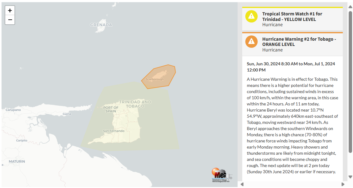
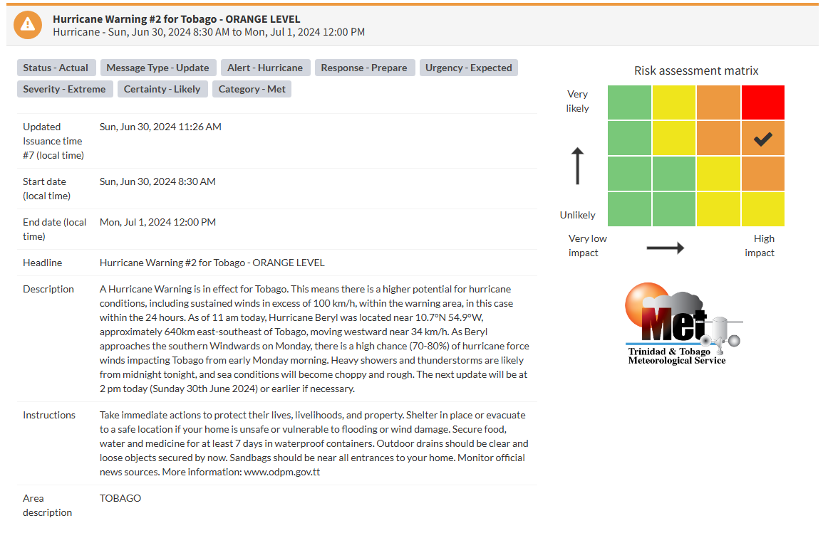
“A Hurricane Warning is in effect for Tobago. This means there is a higher potential for hurricane conditions, including sustained winds in excess of 100 KM/H, within the warning area, in this case within the (next) 24 hours. As of 11:00 AM today, Hurricane Beryl was located near 10.7°N 54.9°W, approximately 640 KM east-southeast of Tobago, moving westward near 34 KM/H. As Beryl approaches the southern Windwards on Monday, there is a high chance (70-80%) of hurricane-force winds impacting Tobago from early Monday morning. Heavy showers and thunderstorms are likely from midnight tonight, and sea conditions will become choppy and rough. The next update will be at 2:00 PM today (Sunday, June 30th, 2024) or earlier if necessary.” according to the Trinidad and Tobago Meteorological Service.
Why am I under a Hurricane Watch or Warning?
A Hurricane Warning is an announcement that sustained winds greater than 74 MPH or 119 KM/H are expected somewhere within the specified area within 36 hours in association with a tropical, subtropical, or post-tropical cyclone.
A Hurricane Watch is an announcement that sustained winds of greater than 74 MPH or 119 KM/H are possible within the specified area within 48 hours in association with a tropical, subtropical, or post-tropical cyclone.
This specific watch or warning is based on the potential for experiencing hurricane-force winds alone, not the other hazards associated with a hurricane (hazardous seas, torrential rainfall, etc.). This means if the system tracks close to your country, but the strongest winds remain offshore or north/east of your location, you may not be placed under a Hurricane watch or warning, but you may have other advisories in effect.

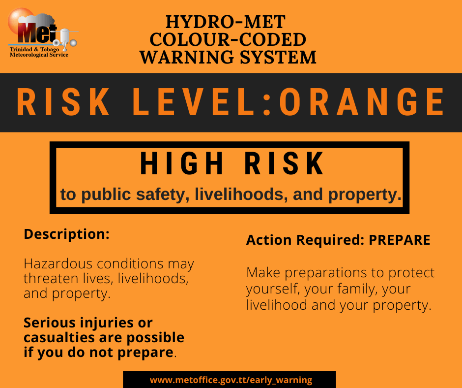
The color of the warning indicates the severity of the event and the probability of the event occurring. Currently, the warning level is orange. This means that the hazards are likely, and the severity of impacts is extreme for this particular warning. For the island of Tobago, the public should prepare for the hazards associated with strong winds and gusts, street/flash flooding, frequent lightning in thunderstorms, and landslides. Seas will also become hazardous, and mariners should prepare for large waves in nearshore areas, particularly Atlantic-facing coastlines, as well as life-threatening storm surge.
At an Orange Level, there is a high risk to public safety, livelihoods and property with hazardous conditions threatening lives, livelihoods, and property. According to the TTMS guidance on their Early Warning System, at this level, serious injuries or casualties are possible if you do not prepare.
The TTMS says extreme impacts are possible. This means that there is the potential for the loss of multiple lives, with widespread, catastrophic losses for the exposed population, where income earning becomes impossible for weeks. Island-wide devastation is possible, where external help will be needed.
The TTMS is advising the public in Tobago to take immediate action to protect lives, livelihoods, and property. They add that the public should shelter in place or evacuate to a safe location if their home is unsafe or vulnerable to flooding or wind damage. The public should secure food, water, and medicine for at least seven days in waterproof containers. Outdoor drains should be clear, and loose outdoor objects should be secured by now. The Met Office says sandbags should be near all entrances to your home.
Conditions are likely to deteriorate overnight Sunday through Monday morning, so preparations need to be rushed to completion in Tobago.