


History was made on Saturday as Beryl rapidly strengthened from Tropical Depression Two to hurricane-strength in less than 24 hours, a feat for this time of year, becoming the earliest hurricane to form this far south and east since 1933.
Steady to rapid intensification is forecast before Beryl barrels through the Windward Islands. The National Hurricane Center forecasts the system to become a “dangerous major hurricane” before reaching the Windwards at Category 3 strength with maximum sustained winds of 205 KM/H and gusts to 250 KM/H.
The last time a major hurricane tracked through the Windwards was Hurricane Ivan in 2004, which devastated Grenada.
Based on the forecast path, this system is forecast to move north of Trinidad and Tobago. The heaviest rains and strongest winds will occur between Tobago and St. Lucia, moving across Grenada, St. Vincent and the Grenadines, St. Lucia and Barbados.
What you need to know
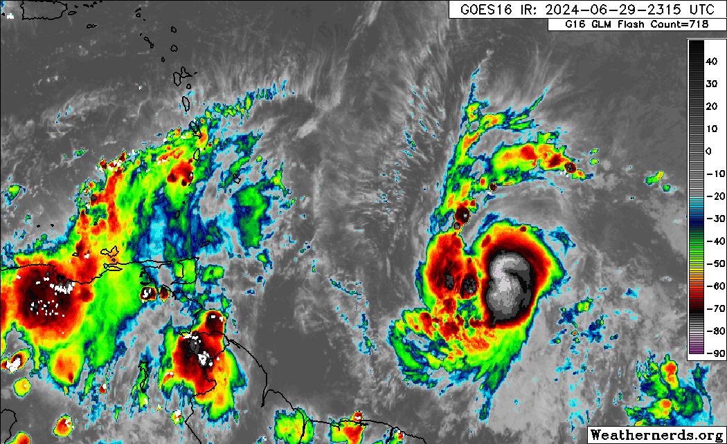
— What has happened: Hurricane Beryl continues to strengthen and organize east of the Windward Islands, approximately 1,025 kilometers east of Tobago. Conditions remain conducive for rapid strengthening over the next 24-36 hours before it reaches the Windward Islands.
— Where is it forecast to move: Forecast models and the National Hurricane Center show Hurricane Beryl remaining north of Trinidad and Tobago, moving across the southern Windwards between Grenada and St. Vincent. This system is likely to impact the region from Sunday night through Monday.
— The Intensity & Impacts: Life-threatening winds, seas, and storm surge are expected within the hurricane warning area, particularly where the eyewall traverses. Heavy rainfall is forecast to affect the Windward Islands, from Trinidad and Tobago to Guadeloupe, with the most intense rain affecting Barbados and Grenada to St. Lucia.
— Latest from officials: Hurricane Warnings are in effect for Barbados, Grenada, St. Vincent and the Grenadines, and St. Lucia while Tropical Storm Warnings are in effect for Tobago and Martinique. A Tropical Storm Watch is in effect for Dominica.
The latest

At 11:00 PM, the center of Hurricane Beryl was located near latitude 10.4 North and longitude 51.2 West. Beryl is moving quickly toward the west near 20 mph (31 km/h). A continued quick westward to west-northwestward motion is expected during the next few days. On the forecast track, the center of Beryl is expected to move across the Windward Islands late Sunday night and Monday.
Maximum sustained winds have increased to near 140 KM/H with higher gusts. Rapid strengthening is forecast over the next day or so, and Beryl is expected to become a dangerous major hurricane before it reaches the Windward Islands.
Hurricane-force winds extend outward up to 30 kilometers from the center, and tropical-storm-force winds extend outward up to 110 kilometers. The estimated minimum central pressure is 986 millibars.
Beryl continues to strengthen rapidly this evening. Cold convective cloud tops between -70 and -80 C are now wrapping fully around the center after earlier being confined to its southern semicircle. After the prior advisory, a late-arriving SSMIS microwave pass revealed a small closed eyewall now exists.
Both the NOAA and Air Force Reserve Hurricane Hunters will investigate Beryl tomorrow morning, which will provide our first in-situ data to assess the hurricane.
Latest Alerts, Watches & Warnings

Hurricane Warnings
A Hurricane Warning is in effect for Barbados, St. Lucia, St. Vincent and the Grenadines, and Grenada.
A Hurricane Warning means that hurricane conditions are expected somewhere within the warning area. A warning is typically issued 36 hours before the anticipated first occurrence of tropical-storm-force winds, conditions that make outside preparations difficult or dangerous. Preparations to protect life and property should be rushed to completion.
Tropical Storm Warnings
A Tropical Storm Warning is in effect for Tobago and Martinique.
A Tropical Storm Warning means that tropical storm conditions with winds of 39 to 73 MPH (63 to 118 KM/H) are expected somewhere within the warning area within 36 hours.
Tropical Storm Watches
A Tropical Storm Watch is in effect for Dominica.
A Tropical Storm Watch is issued when Tropical storm conditions, with sustained winds of 39 to 73 MPH (63 to 118 KM/H), are possible within the specified area within 48 hours.
The National Hurricane Center says interests elsewhere in the Lesser Antilles should closely monitor the progress of Beryl. Additional watches and warnings may be required tomorrow (Sunday).
Where is it going?

A strong subtropical ridge should keep the storm moving generally westward to west-northwestward at a similar forward speed for the next few days. This motion should take Beryl across the Windward Islands late Sunday night and Monday, and then across the eastern and central Caribbean Sea early next week.
A subtle weakness in this ridging in the 24-48 hour period should help the hurricane gain a bit of latitude before the ridge builds back in over the southeastern U.S. by the middle of next week, likely resulting in a turn back more westward by the end of the forecast period.
As of Saturday morning, Hurricane Beryl poses a direct threat north of Tobago and across the southern and central Windwards, from Grenada to Martinique. Strong wind gusts are possible across the northern Windwards.

How strong could it get?
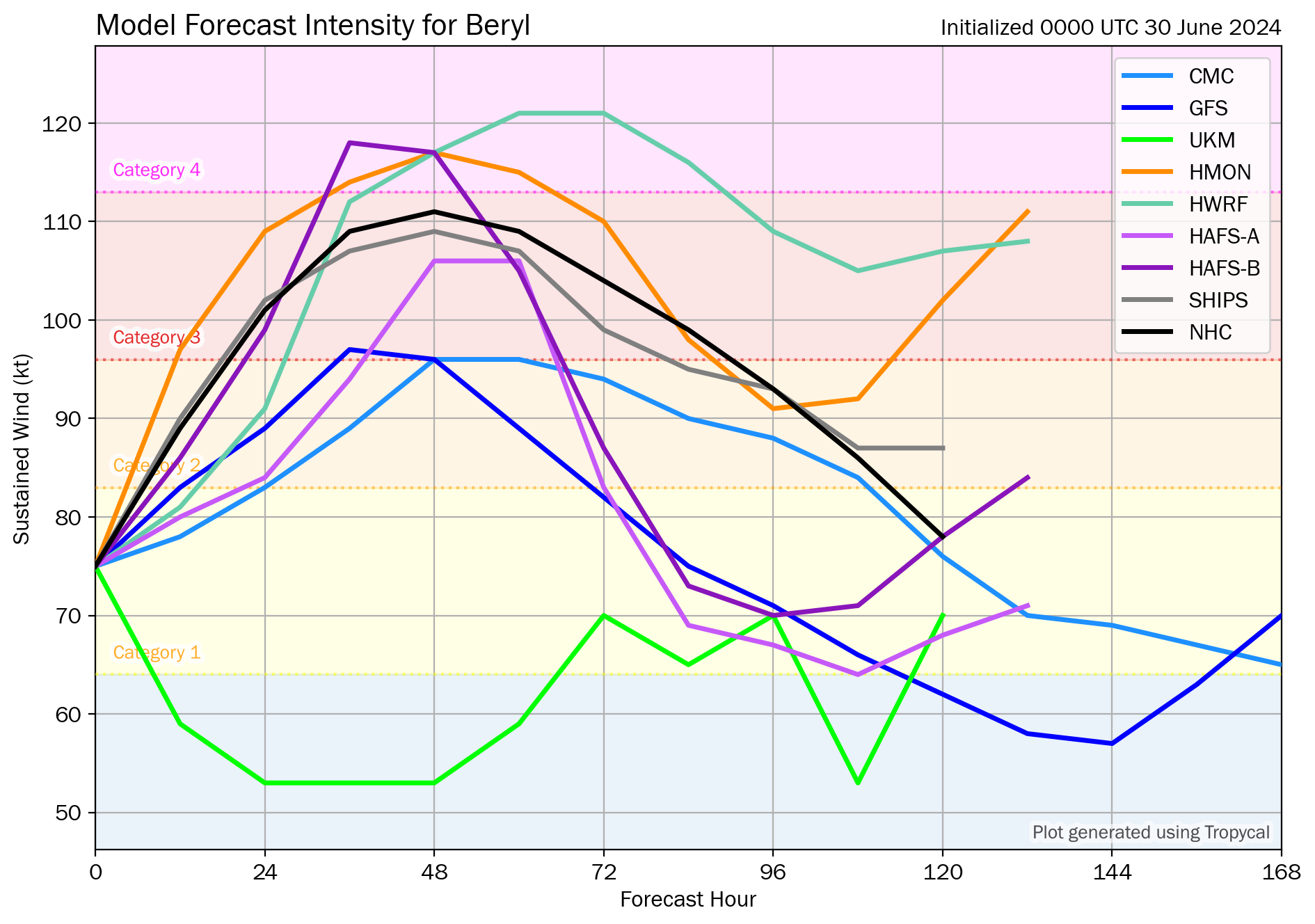
Unfortunately Beryl has all the ingredients favorable for continued rapid intensification in the short-term. The light to moderate easterly shear that had been affecting the system is subsiding, while the hurricane remains embedded in a large area of deep-layer moisture and over 28-29°C sea-surface temperatures. The small and well-organized inner core likely means the hurricane should take full advantage of these pristine conditions.
The latest NHC intensity forecast will explicitly show rapid intensification over the next day, making Beryl a very dangerous Category 3 hurricane before it moves across the Windward islands by tomorrow night.
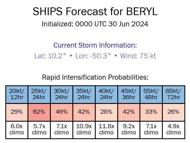
With Beryl set to move across the Windwards within the next 36 hours, the 00Z Sunday SHIPS guidance shows a 42% chance, based on climatology, of rapid intensification, increasing up to 45 knots in 36 hours before it reaches the Windward Islands.
What does this mean for the Lesser Antilles?
Unfortunately, a historic hurricane is likely to move through the Windward Islands within the next 36 to 48 hours. Beryl is expected to be a dangerous major hurricane when it reaches the Windward Islands late Sunday night or Monday, bringing destructive hurricane-force winds and life-threatening storm surge.
Heavy rainfall and localized flooding are expected across the Windward Islands Sunday night and Monday.
Tropical cyclone preparedness plans should be executed and rushed to completion for the southern and central Lesser Antilles. There is a high risk of heavy rainfall that will produce floods, landslides, and mudslides, as well as damaging winds and gusts.
Wind

Based on the latest guidance, tropical storm-force wind gusts and sustained winds (above 34 knots, 39 MPH, 63 KM/H) are forecast to affect the Windwards. This includes from Tobago through Dominica, with isolated strong gusts northward in isolated heavy showers or thunderstorms.
Near the core of this system, the official forecast from the National Hurricane Center has a Category 3 hurricane with maximum sustained winds of 205 KM/H and gusts to 250 KM/H moving across the Windwards on Monday morning.

Tobago has been placed under a Tropical Storm Warning as it lies on the southern edge of Hurricane Beryl’s cone of uncertainty. There is a low to medium (30% to 50%) chance of tropical storm conditions for Tobago. For Trinidad, the probability of tropical storm conditions is low—between 10-20% for northern Trinidad and 5-10% for southern Trinidad.
At this point in time, the probability for hurricane conditions across Tobago is low, between 5-10% across most of Tobago, and in the extreme northeastern areas of the island, between 10-20%.
Wind-wise, for Trinidad and Tobago outer bands of this system are likely to affect the country from Sunday night, with more intense activity after midnight through Monday morning. Then, From Monday afternoon through Tuesday morning and in feeder band activity, the pressure gradient between the low-pressure system north of T&T and a high-pressure system over northern South America will lead to strong low-level southeasterly winds across the area. These winds can reach the surface in showers or thunderstorms. Wind gusts exceeding 50 KM/H are likely during this period, and gusts exceeding 75 KM/H are possible. For Tobago, stronger winds are likely, with sustained winds and gusts between 63 and 118 KM/H, and as a result, Tobago is under a Tropical Storm Warning at this time.
Latest Tropical Storm Warning for Tobago

Why are you not under a Tropical Storm or Hurricane Watch or Warning?
Rainfall

The highest rainfall accumulations are forecast to occur between Grenada and St. Lucia, including Barbados. Rainfall totals through Tuesday, July 2nd, 2024, will range between 100 and 150 millimeters (4-6 inches), with isolated totals up to 250 millimeters (10 inches).
Across the remainder of the central Windwards, between 50 and 100 millimeters (2-4 inches) of rainfall is likely, with isolated totals up to 150 millimeters (6 inches) favoring windward (eastern) coastlines.
Trinidad and Tobago will likely experience between 50 and 100 millimeters (2-4 inches) of rainfall, with isolated totals up to 150 millimeters (6 inches) favoring windward (eastern) coastlines.
For the southernmost Leewards, rainfall totals are forecast to be as high as 25 millimeters (1 inch), with isolated totals of up to 50 millimeters, favoring southern and eastern coastlines.
Seas and Storm Surge
The strongest winds associated with the eventual Hurricane Beryl are forecast to remain north of the center of circulation, leading to higher waves and swells affecting the southern and central Windwards. However, due to the large spread of intensity models, there is also a spread of wave models as well.
A life-threatening storm surge will raise water levels by as much as 5 to 7 feet above normal tide levels in areas of onshore flow in the hurricane watch areas. Near the coast, the surge will be accompanied by large and destructive waves.
Based on the latest model guidance, waves south of Guadeloupe and north of Tobago are forecast to be above 3.5 meters. Peak waves are forecast to occur north of Tobago and south of Martinique, with peak heights ranging from 4.5 meters to 10 meters in open waters. The Barbados Meteorological Service is forecasting waves as high as 8 meters (26 feet) near their area of responsibility.
For T&T, rough seas are likely on Sunday night through Tuesday, mainly along the country’s eastern and northern offshore areas, with waves 2.5 and 3.5 meters in open waters, occasionally higher in northeastern waters. Forecast models also indicate waves as high as 4.5 meters in open waters north and east of Tobago.
Again, this is based on current track and intensity guidance, which can change in the coming days.
For Trinidad and Tobago
For Trinidad and Tobago, given this system is forecast to generally remain north of the country, feeder band activity poses the most risk, with locally heavy rain, accompanied by potentially damaging wind gusts. Stronger southerly winds may also lead to isolated thunderstorms being enhanced by topography on Monday afternoon, particularly along the south-facing slopes of the Northern Range, and with near-calm to light winds mainly on Monday and with clockwise turning winds through the atmosphere, the potential for funnel clouds will also exist. Rough seas are also likely, mainly in northern and eastern coastal waters.
On Monday evening through Tuesday morning, with southerly to southwesterly winds, strong evening thunderstorms may also move off the Venezuelan coastline south of Trinidad and move toward the country in the Gulf of Paria, creating hazardous marine conditions and producing frequent, dangerous lightning. Forecast models show on Tuesday, a feeder band may also develop east of Trinidad, affecting Tobago.
Latest Weather Forecast For T&T

Wet Condtions Forecast For T&T Into Weekend
Pay close attention to official forecasts in the coming hours and days from your respective authorities. For Trinidad and Tobago, official forecasts and early warnings come from the Trinidad and Tobago Meteorological Service.


