Trinidad and Tobago and the Southern Windward Islands have entered rare territory. The last time a hurricane close to this magnitude moved through the Windwards was Hurricane Ivan in 2004, which strengthened from Category 3 to 4 as it moved south of Grenada, and before that was Hurricane Allen in 1980. Both of these systems, while historic, moved through the Windwards at a “weaker” magnitude.
What you need to know
— Rainfall: Through Thursday morning, across Trinidad, rainfall accumulations between 25 and 50 millimeters are likely, while across Tobago, accumulations between 25 and 75 millimeters are likely, with isolated totals favoring the northern half of Trinidad and Tobago exceeding 150 millimeters, particularly where feeder band activity develops.
— Hazards: Through Monday midday: Hurricane conditions are expected across Tobago, while Tropical Storm conditions are expected across Trinidad through midday Monday, with sustained winds and gusts between 63 and 118 KM/H possible, particularly in heavy showers/thunderstorms. For Tobago, there is a higher potential for sustained winds and gusts exceeding 118 KM/H. After Monday midday, when tropical cyclone warnings are discontinued, gusty winds up to 55 KM/H are possible, and accompanying locally intense rainfall is likely to produce street/flash flooding with frequent lightning in intense thunderstorm activity. Landslides are possible in elevated areas, particularly in northern Trinidad and across Tobago. Funnel cloud activity is possible on Monday afternoon across Trinidad and hazardous seas.
— Marine: Rough seas are likely to begin on Sunday night, with waves above 2.5 meters, reaching as high as 5.0 meters north of Tobago. In sheltered areas, especially within the Gulf of Paria, choppy conditions are likely, with waves as high as 1.5 meters in heavy shower/thunderstorm activity.
Latest Alerts
TTMS Issues Adverse Weather Alert For T&T
Trinidad and Tobago is NOT under any tropical storm or hurricane threat, watch, or warning at this time.
The Forecast
Sunday Night
Sunday NightMonday – Tobago
Monday – TobagoMonday – Trinidad
Monday – TrinidadTuesday
TuesdayWednesday
WednesdayMarine Forecast
From Sunday night through Tuesday morning, waves in open waters are forecast to vary between 2.0 meters and 3.5 meters, particularly north and east of Trinidad, with open water waves as high as 5 meters just north of Tobago. In sheltered areas, seas are forecast to be choppy, with waves between 1.0 and 1.5 meters. Within the Gulf of Paria, due to shifting winds, larger-than-usual waves are forecast on north-facing coastlines on Sunday night, then west-facing coastlines early Monday, and then north-facing coastlines on Monday afternoon into Tuesday morning. Swell periods during this time will peak at 17 seconds on Sunday night, causing large, battering waves in nearshore areas. Hurricane conditions are expected in offshore areas.
A life-threatening storm surge will raise water levels by as much as 6 to 9 feet above normal tide levels in areas of onshore flow near where Hurricane Beryl’s eye makes landfall in the hurricane warning area (Tobago). Near the coast, the surge will be accompanied by large and destructive waves from Sunday night through midday Monday.
Mariners should ensure all vessels are securely anchored/docked as choppy/breaking wave conditions may drag vessels onto the ocean floor in shallow waters or even break anchorage or mooring. Consider hauling your vessel out of the water.
From Tuesday through Wednesday, moderate to occasionally rough seas are forecast with waves between 1.5 and 2.5 meters, becoming rough by Wednesday night.
Temperatures
Monday
Low: 23-25°C
High: 28-31°C
Tuesday
Low: 24-26°C
High: 31-34°C
Wednesday
Low: 25-28°C
High: 32-34°C
Forecast Impacts
Flooding – Tobago
Flooding – TobagoFlooding – Trinidad
Flooding – TrinidadForecast Rainfall Totals
- Sunday: Less than five millimeters of rainfall across Trinidad, with isolated totals up to 15 millimeters favoring southwestern Trinidad, northeastern Trinidad, and Tobago.
- Monday: Up to 25 millimeters of rainfall are forecast across Trinidad, with totals up to 50 millimeters across the northern half of Trinidad. For Tobago, between 25 and 75 millimeters of rainfall are expected. In Hurricane Beryl’s feeder band activity and in heavy showers/thunderstorms, locally higher totals are likely.
- Tuesday: Across the country, between 5 and 15 millimeters are forecast, with totals up to 25 millimeters, favoring southern and eastern Trinidad, as well as Tobago. In isolated thunderstorm activity, rainfall totals exceeding 25 millimeters are likely.

Understanding Rainfall Accumulations
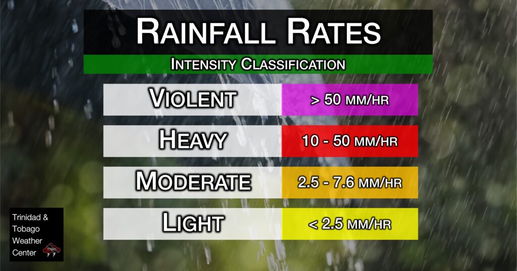
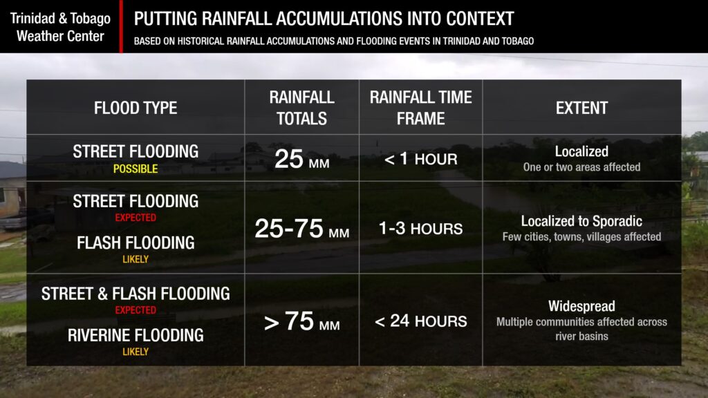
Putting the rainfall forecast into context, rainfall rates in excess of 50 millimeters per hour or areas that receive in excess of 25 millimeters within an hour tend to trigger street flooding across the country or flash flooding in northern Trinidad. For riverine flooding to occur, a large area of the country (not just in highly localized areas of western coastal Trinidad) would have to record upwards of 75 millimeters within 24 hours, and rainfall would have to fall across major rivers’ catchment areas.

Strong Thunderstorms
Strong ThunderstormsWhat is a strong or severe thunderstorm?
Given how rare these types of thunderstorms are in our region – we classify a severe or strong thunderstorm as one that produces any of the following:
- Damaging wind gusts exceeding 55 KM/H;
- Frequent lightning (more than 30 cloud-to-ground strikes within a 10-minute period);
- Hail (of any size);
- Rainfall of more than 50 millimeters or more within an hour or exceeding 75 millimeters or more within three hours;
- The sighting of a funnel cloud or touchdown of a waterspout/tornado associated with the thunderstorm.
Gusty Winds – Tobago
Gusty Winds – TobagoGusty Winds – Trinidad
Gusty Winds – TrinidadWith wind gusts and sustained winds in excess of 118 KM/H forecast due to Hurricane Beryl, well-constructed frame homes could have damage to roofs and gutters. Large branches of trees will snap, and shallowly rooted trees may be toppled. Extensive damage to power lines and poles likely will result in power outages that could last a few to several days.
Wind speeds atop and on the windward sides of hills and mountains are often up to 30 percent stronger than the near-surface winds forecasted and, in some elevated locations, could be even greater.


