


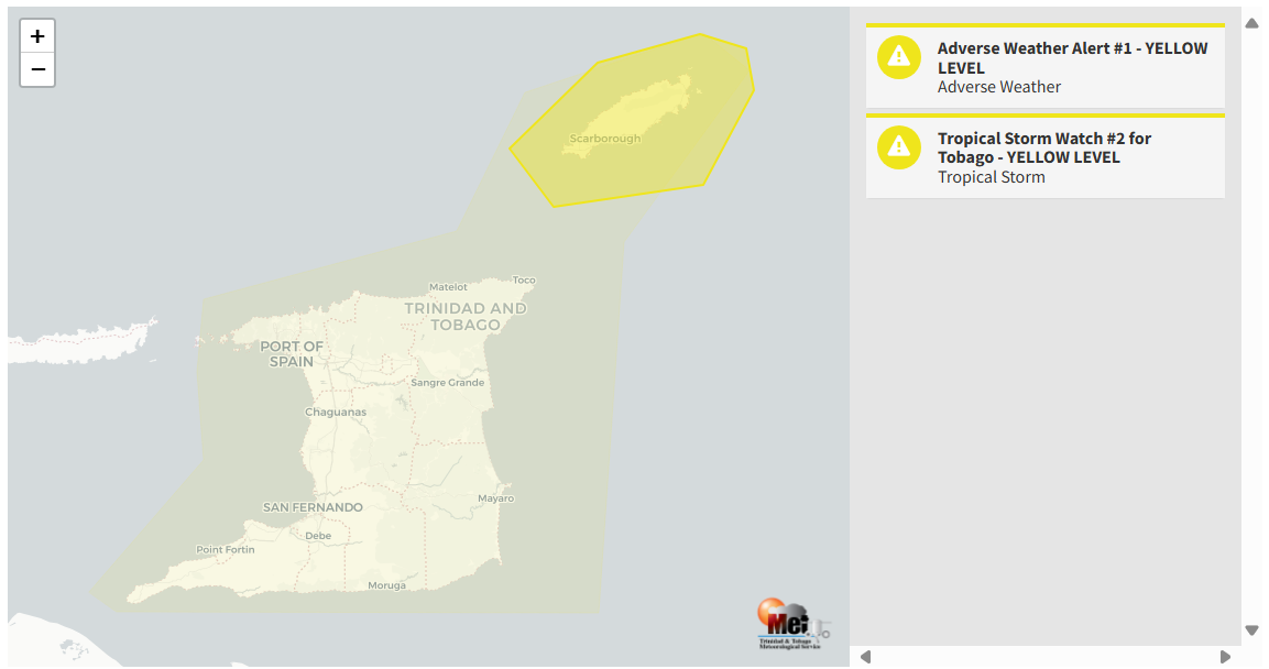
A Tropical Storm Watch remains in effect for Tobago. This is ahead of now Hurricane Beryl as it nears the Windward Islands. While the core of this system is forecast to remain north of Trinidad and Tobago, tropical storm conditions are possible across Tobago. Hence, the watch is being issued. However, there is a low to medium chance (30-40%) of Tobago experiencing tropical storm-force winds.
What you need to know
— Rainfall: Over the next five days through the night of July 3rd, 2024, overall rainfall accumulations across the country are forecast to range from 40 to 110 millimeters, with totals up to 125 millimeters favoring northern and eastern areas of Trinidad, as well as Tobago and localized western parts of Trinidad. In isolated areas, five-day totals may reach as high as 175 millimeters.
— Hazards: A Tropical Storm Watch means that tropical-storm-force winds (63-118 KM/H) are possible within 48 hours, in this case, within 42 hours. Over the next five days, several hazards are forecast. In heavy showers/thunderstorms, there is the risk of gusty winds exceeding 45 KM/H, up to 65 KM/H across Trinidad, with higher gusts across Tobago, locally intense rainfall producing street/flash flooding, frequent lightning in intense thunderstorm activity, landslides in elevated areas, particularly northern Trinidad and Tobago, funnel cloud activity on Monday, and hazardous seas.
— Marine: Hazardous conditions are possible in the Gulf of Paria from Monday through Tuesday, while northern and eastern open waters are forecast to see rough seas from Sunday night through Tuesday morning, with waves as high as 4.5 meters.
Latest Alerts

Adverse Weather Alert Issued For T&T As ITCZ Affects Country
Trinidad and Tobago is NOT under any tropical storm or hurricane threat, watch, or warning at this time.
The Tropical Storm Watch
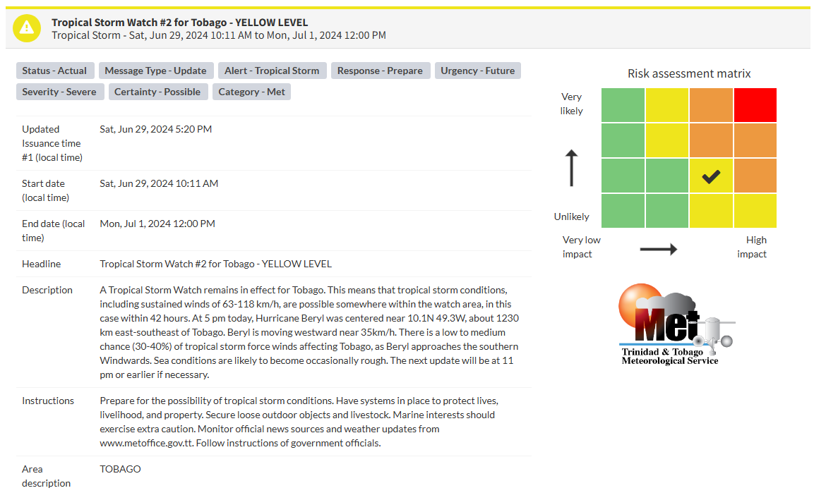
The Trinidad and Tobago Meteorological Service (TTMS), in conjunction with the National Hurricane Center, has maintained the Tropical Storm Watch on Saturday at 5:20 PM. According to the Trinidad and Tobago Meteorological Service, this watch will remain in effect for Tobago until 12:00 PM (noon) on Monday, July 1st, 2024.
Why am I under a tropical storm watch or warning?
A tropical storm warning is an announcement that sustained winds of 34 to 63 knots (39 to 73 mph or 63 to 118 km/hr) are expected somewhere within the specified area within 36 hours in association with a tropical, subtropical, or post-tropical cyclone.
A tropical storm watch is an announcement that sustained winds of 34 to 63 knots (39 to 73 mph or 63 to 118 km/hr) are possible within the specified area within 48 hours in association with a tropical, subtropical, or post-tropical cyclone.
This specific watch or warning is based on the potential for experiencing tropical-storm-force winds alone, not the other hazards associated with a tropical storm (hazardous seas, torrential rainfall, etc.). This means if the system tracks close to your country, but the strongest winds remain offshore or north/east of your location, you may not be placed under a tropical storm watch or warning, but you may have other advisories in effect.
“A Tropical Storm Watch remains in effect for Tobago. This means that tropical storm conditions, including sustained winds of 63-118 KM/H, are possible somewhere within the watch area, in this case, within 42 hours. At 5:00 PM today, Hurricane Beryl was centered near 10.1N 49.3W, about 1230 KM east-southeast of Tobago. Beryl is moving westward near 35 KM/H. There is a low to medium chance (30-40%) of tropical storm force winds affecting Tobago as Beryl approaches the southern Windwards. Sea conditions are likely to become occasionally rough. The next update will be at 11:00 PM or earlier if necessary.” according to the Trinidad and Tobago Meteorological Service.

The color of the watch indicates the severity of the event and the probability of the event occurring. Currently, the watch level is yellow. This means that the hazards are possible, but the severity of impacts is severe for this particular watch. For the island of Tobago, the public should be aware of the hazards associated with strong wind gusts, street/flash flooding, frequent lightning in thunderstorms, and landslides. Seas will also become hazardous, and mariners should prepare for large waves in nearshore areas, particularly Atlantic-facing coastlines.
At a Yellow Level, there is a moderate risk to public safety, livelihoods and property, with some disruptions possible in a few places.
However, the TTMS says severe impacts are possible. This means that conditions may result in the loss of a single life or serious injuries, physical defenses are needed, major losses in confined areas, and income earning impossible for several days, with several communities being affected. External help is needed for recovery.
The TTMS is advising the public in Tobago to prepare for the possibility of tropical storm conditions and secure loose outdoor objects and livestock; marine interests should exercise extra caution during this period and monitor official news sources and weather updates.
With conditions likely to deteriorate on Monday, those in Tobago should make preparations to protect yourself, your family, your livelihood, and your property. Plan your evacuation to a shelter if it becomes necessary. Always have emergency supplies of food and water on standby. Do not wade or drive through flood waters. Pre-position sandbags if your area floods and monitor river levels.


