


Tropical Storm Beryl is likely undergoing a period of rapid intensification as it moves towards the Windward Islands. The National Hurricane Center is now forecasting Beryl to become a “dangerous major hurricane” before reaching the Windwards at Category 3 strength.
The last time a major hurricane tracked through the Windwards was Hurricane Ivan in 2004, which devastated Grenada.

Multiple tropical storm and hurricane watches were issued on Saturday morning with additional watches and warnings likely to be issued later today.
Based on the forecast path, this system is forecast to move north of Trinidad and Tobago. The heaviest rains and strongest winds will occur between Tobago and St. Lucia, moving across Grenada, St. Vincent and the Grenadines, St. Lucia and Barbados.
What you need to know
— What has happened: Tropical Storm Beryl continues to strengthen and organize east of the Windward Islands, approximately 1,450 kilometers east of Tobago. Conditions remain conducive for rapid strengthening over the next two days.
— Where is it forecast to move: Forecast models and the National Hurricane Center show Tropical Storm Beryl remaining north of Trinidad and Tobago, moving across the southern Windwards. This system is likely to impact the region from Sunday night through Monday.
— The Intensity & Impacts: Heavy rainfall is forecast to affect the Windward Islands, from Trinidad and Tobago to Guadeloupe, with the most intense rain affecting Barbados and Grenada to St. Lucia. Rough seas are forecast to affect much of the Lesser Antilles. Hurricane conditions are possible across Barbados and Grenada to St. Lucia, while Tropical Storm conditions are possible across Tobago and Martinique.
— Latest from officials: Tropical Storm Watches are in effect for Tobago and Martinique, with Hurricane Watches in effect for Barbados, Grenada, St. Vincent and the Grenadines and St. Lucia. 2:00 PM Update: A Tropical Storm Watch was issued for Dominica.
The latest

At 11:00 AM, the center of Tropical Storm Beryl was located near latitude 10.0 North, longitude 47.8 West. Beryl is racing toward the west near 37 KM/H. A relatively quick westward to west-northwestward motion is expected during the next few days. On the forecast track, the system is expected to move across the Windward Islands late Sunday night and Monday.
Maximum sustained winds have increased to near 100 KM/H with higher gusts. Rapid strengthening is now forecast, and Beryl is expected to become a major hurricane before it reaches the Windward Islands. Tropical-storm-force winds extend outward up to 45 miles 75 kilometers from the center. The estimated minimum central pressure is 998 millibars.
Overnight through Saturday morning, Beryl is producing showers and thunderstorms organized in curved bands, with the storm becoming more symmetric. The latest satellite and microwave imagery shows that Beryl is developing an eyewall near the center of circulation, a precursor to rapid strengthening.
Latest Alerts, Watches & Warnings

Hurricane Watches
A Hurricane Watch is in effect for Barbados, Grenada, St. Vincent and the Grenadines.
A Hurricane Watch is issued when hurricane conditions, with sustained winds of 74 MPH (119 KM/H) or greater, are possible within your area within 48 hours. Because it may not be safe to prepare for a hurricane once winds reach tropical storm force, the NHC issues hurricane watches 48 hours before it anticipates tropical-storm-force winds.
Tropical Storm Watches
A Tropical Storm Watch is in effect for Martinique and Tobago. 2:00 PM Update: A Tropical Storm Watch was issued for Dominica. A Tropical Storm Watch is issued when Tropical storm conditions, with sustained winds of 39 to 73 MPH (64 to 118 KM/H), are possible within the specified area within 48 hours.
The National Hurricane Center says interests elsewhere in the Lesser Antilles should closely monitor the progress of Beryl. Additional watches and warnings will likely be required for portions of this area later today.
Where is it going?
A strong subtropical ridge should keep the storm moving generally westward at only a slightly slower forward speed for the next few days. This motion should take Beryl across the Windward Islands late Sunday night and Monday, and then across the eastern and central Caribbean Sea early next week.
When the system moves into the Caribbean Sea, Beryl nears a weakness in the subtropical ridge. As a result, Beryl is forecast to track across the eastern and central Caribbean Sea
through the middle of next week, before another ridge builds to its northwest. The NHC has adjusted this later portion of the track southward based on latest model trends.
As of Saturday morning, Tropical Storm Beryl poses a threat north of Tobago and across the southern and central Windwards, from Grenada to Martinique. Strong wind gusts are possible across the northern Windwards.

How strong could it get?

Unfortunately, rapid intensification is likely. The storm has been on a steady strengthening trend since it formed yesterday, and now that its structure is more symmetric and compact,
it likely will have an opportunity to rapidly intensify, given the low wind shear conditions. The new NHC intensity forecast explicitly calls for rapid strengthening and shows Beryl becoming a major hurricane before moving across the Windward Islands.
Atmospheric and oceanic conditions, atypical for this time of year, are fairly favorable for strengthening the next few days with warm sea surface temperatures, plenty of moisture, and low vertical wind shear.
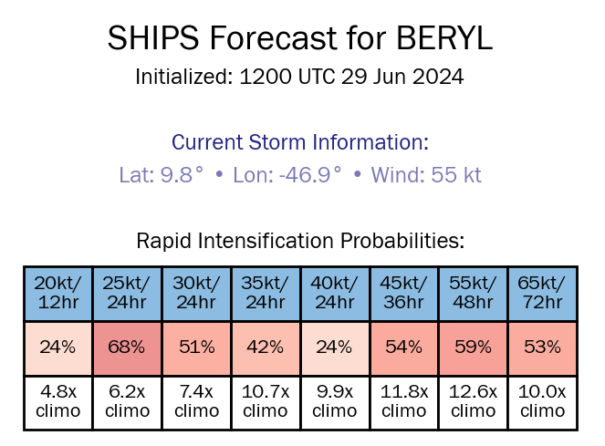
The 12Z SHIPS guidance shows a 50-60% chance, based on climatology, of rapid intensification, increasing up to 55 knots in 48 hours before it reaches the Windward Islands. A number of hurricane models show that if an eye/eye wall can develop early, a powerful hurricane is possible as it nears the Windwards on Monday.
What does this mean for the Lesser Antilles?
Tropical Storm Beryl is expected to strengthen and become a hurricane when it reaches the Windward Islands late Sunday night through Monday. It will bring a risk of heavy rainfall, hurricane-force winds, and dangerous storm surges and waves.
Tropical cyclone preparedness plans should be executed for the southern and central Lesser Antilles. There is an increasing risk of heavy rainfall that will produce floods, landslides, and mudslides, as well as strong winds and gusts that can cause wind damage and rough seas.
Wind

Based on the latest guidance, tropical storm-force wind gusts, and sustained winds (above 34 knots, 39 MPH, 63 KM/H) are forecast to primarily affect the Windwards. This includes from Tobago through Martinique, with isolated strong gusts northward in isolated heavy showers or thunderstorms.
Near the core of this system, the official forecast from the National Hurricane Center has a Category 3 hurricane with maximum sustained winds of 185 KM/H and higher gusts to 220 KM/H moving across the Windwards on Monday morning.

Tobago has been placed under a Tropical Storm Watch as it lies on the southern edge of Tropical Storm Beryl track’s cone of uncertainty, and there is a low to medium (30% to 40%) chance of Tropical Storm conditions. For Trinidad, the probability for Tropical Storm conditions is low (10-20%).
Wind-wise, for Trinidad and Tobago outer bands of this system are likely to affect the country from Sunday night, with more intense activity after midnight through Monday morning. Then, From Monday afternoon through Tuesday morning and in feeder band activity, the pressure gradient between the low-pressure system north of T&T and a high-pressure system over northern South America will lead to strong low-level southeasterly winds across the area. These winds can reach the surface in showers or thunderstorms. Wind gusts exceeding 45 KM/H are likely during this period, and gusts up to 60 KM/H are possible. For Tobago, stronger winds are likely, with sustained winds between 63 and 118 KM/H, and as a result, Tobago is under a Tropical Storm Watch at this time.
Latest Tropical Storm Watch for Tobago

Why are you not under a Tropical Storm or Hurricane Watch or Warning?
Rainfall

The highest rainfall accumulations are forecast to occur between Grenada and St. Lucia, including Barbados. Rainfall totals through Tuesday, July 2nd, 2024, will range between 100 and 150 millimeters (4-6 inches), with isolated totals up to 200 millimeters (8 inches).
Across the remainder of the central Windwards, between 50 and 100 millimeters (2-4 inches) of rainfall is likely, with isolated totals up to 150 millimeters (6 inches) favoring windward (eastern) coastlines.
Trinidad and Tobago will likely experience between 50 and 100 millimeters (2-4 inches) of rainfall, with isolated totals up to 150 millimeters (6 inches) favoring windward (eastern) coastlines.
For the southernmost Leewards, rainfall totals are forecast to be as high as 25 millimeters (1 inch), with isolated totals of up to 50 millimeters, favoring southern and eastern coastlines.
Seas and Storm Surge
The strongest winds associated with the eventual Hurricane Beryl are forecast to remain north of the center of circulation, leading to higher waves and swells affecting the southern and central Windwards. However, due to the large spread of intensity models, there is also a spread of wave models as well.
A life-threatening storm surge will raise water levels by as much as 5 to 7 feet above normal tide levels in areas of onshore flow in the hurricane watch areas. Near the coast, the surge will be accompanied by large and destructive waves.
Based on the latest model guidance, waves south of Guadeloupe and north of Tobago are forecast to be above 3.5 meters. Peak waves are forecast to occur north of Tobago and south of Martinique, with peak heights ranging from 4.5 meters to 10 meters in open waters. The Barbados Meteorological Service is forecasting waves as high as 6 meters near their area of responsibility.
For T&T, rough seas are likely on Monday and Tuesday, mainly along the country’s eastern and northern offshore areas, with waves 2.5 and 3.5 meters in open waters, occasionally higher in northeastern waters. Forecast models also indicate waves as high as 4.5 meters in open waters north and east of Tobago.
Again, this is based on current track and intensity guidance, which can change in the coming days.
For Trinidad and Tobago
For Trinidad and Tobago, given this system is forecast to generally remain north of the country, feeder band activity poses the most risk, with locally heavy rain, accompanied by potentially damaging wind gusts. Stronger southerly winds may also lead to isolated thunderstorms being enhanced by topography on Monday afternoon, particularly along the south-facing slopes of the Northern Range, and with near-calm to light winds mainly on Monday and with clockwise turning winds through the atmosphere, the potential for funnel clouds will also exist. Rough seas are also likely, mainly in northern and eastern coastal waters.
On Monday evening through Tuesday morning, with southerly to southwesterly winds, strong evening thunderstorms may also move off the Venezuelan coastline south of Trinidad and move toward the country in the Gulf of Paria, creating hazardous marine conditions and producing frequent, dangerous lightning. Forecast models show on Tuesday, a feeder band may also develop east of Trinidad, affecting Tobago.
Latest Weather Forecast For T&T

Wet Condtions Forecast For T&T Into Weekend
Pay close attention to official forecasts in the coming hours and days from your respective authorities. For Trinidad and Tobago, official forecasts and early warnings come from the Trinidad and Tobago Meteorological Service.


