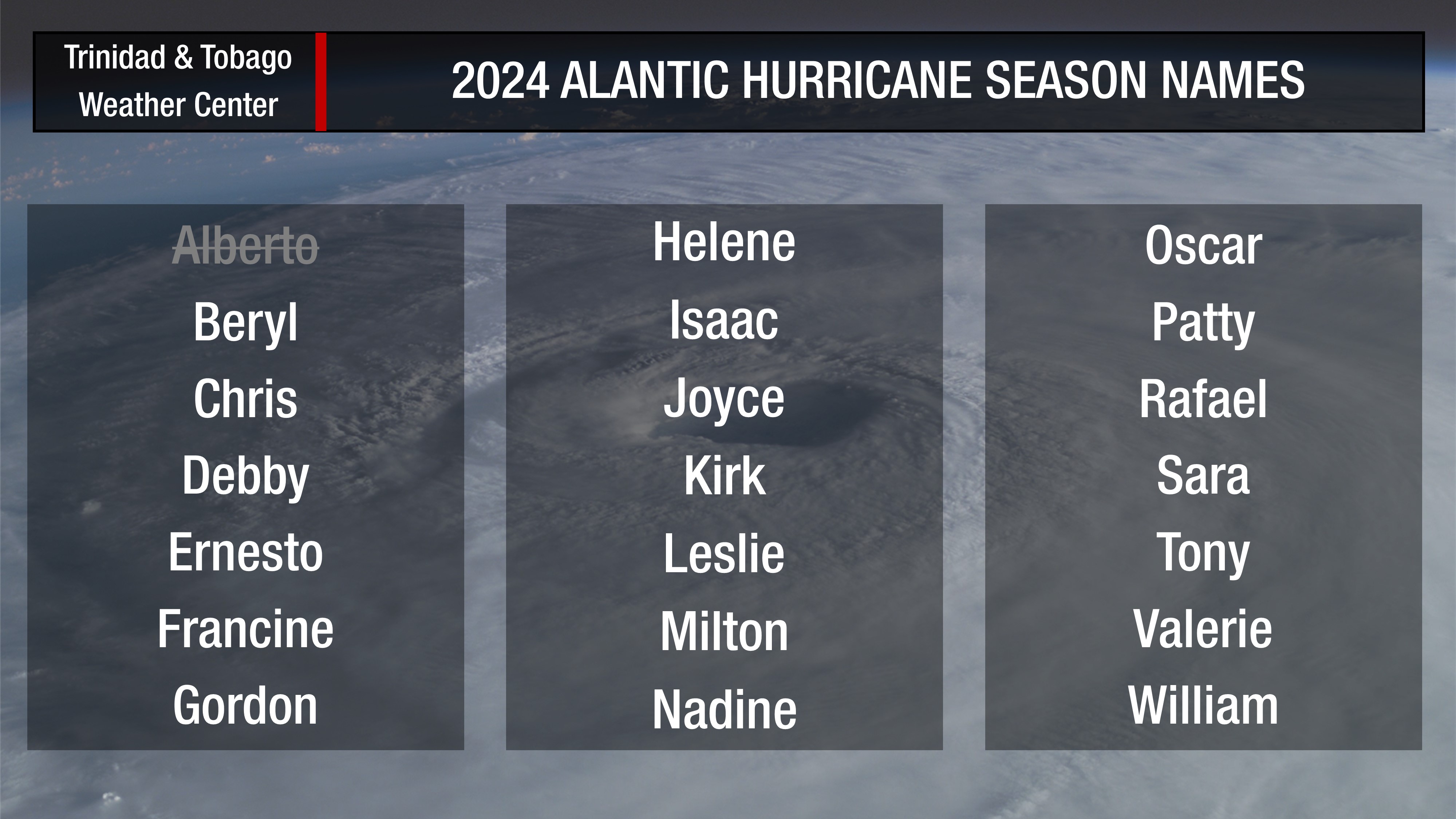
Hours after becoming Tropical Depression Two, Tropical Storm Beryl has formed in the Atlantic becoming this year’s second named storm.
According to the National Hurricane Center, strengthening is likely over the next 24 to 48 hours, and this system is forecast to become a hurricane as it nears the Windward Islands by Sunday night through Monday.
Based on the forecast path, this system is forecast to move north of Trinidad and Tobago. The heaviest rains and strongest winds will occur between Tobago and St. Lucia, moving across Grenada, St. Vincent and the Grenadines, St. Lucia and Barbados.
What you need to know
— What has happened: Tropical Depression Two, formerly Invest 95L, has strengthened into Tropical Storm Beryl east of the Windward Islands, approximately 1,900 kilometers east of Trinidad and Tobago. Conditions remain conducive for strengthening over the next several days.
— Where is it forecast to move: Forecast models and the National Hurricane Center show Tropical Storm Beryl remaining north of Trinidad and Tobago, moving across the southern Windwards. This system is likely to impact the region from Sunday night through Tuesday morning.
— The Intensity & Impacts: Heavy rainfall is forecast to affect the Windward Islands, from Trinidad and Tobago to Guadeloupe, with the most intense rain affecting Barbados and Grenada to St. Lucia. Rough seas are forecast to affect much of the Lesser Antilles. Tropical storm conditions are possible across Grenada to St. Lucia, including Barbados.
— Latest from officials: There are no tropical storm or hurricane watches issued for any islands of the Lesser Antilles. However, Hurricane and Tropical Storm Watches will likely be required for portions of the Windward and southern Leeward Islands early Saturday.
The latest
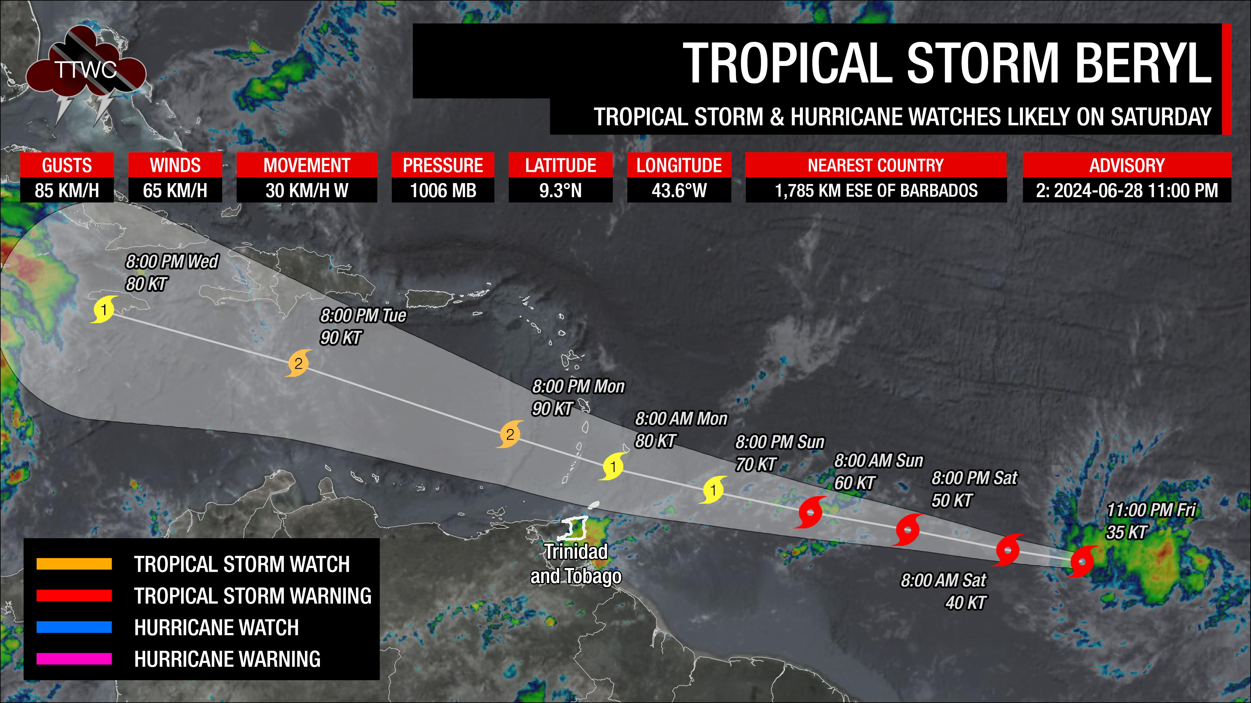
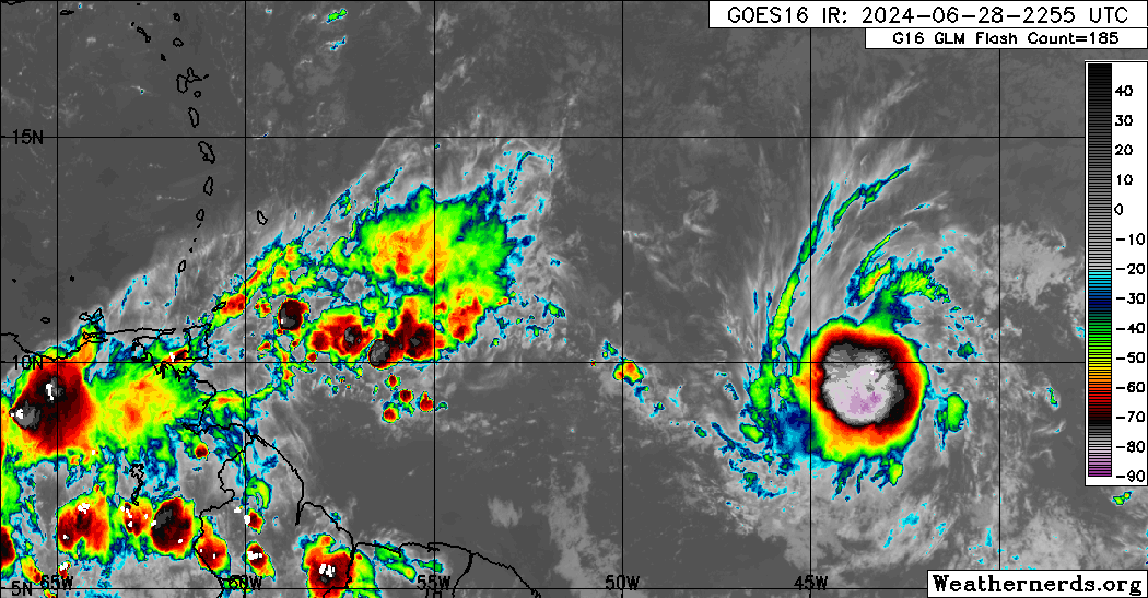
At 11:00 PM, the center of Tropical Storm Beryl was located near latitude 9.3 North and longitude 43.6 West. Beryl is moving toward the west near 30 KM/H. A relatively quick westward to west-northwestward motion is expected during the next few days. On the forecast track, the system is expected to move across the Windward Islands late Sunday night and Monday.
Maximum sustained winds have increased to near 65 KM/H with higher gusts. Steady strengthening is forecast, and Beryl is expected to become a hurricane in a couple of days. Tropical-storm-force winds extend outward up to 75 kilometers from the center. The estimated minimum central pressure is 1006 millibars.
Since becoming a depression earlier Friday afternoon, deep convection has continued to burst with infrared satellite imagery depicting cold cloud tops down to -80C. The center of circulation remains on the eastern side of the deep convection, but the system is gradually becoming better organized with banding features and better vertical alignment.
Latest Alerts, Watches & Warnings
There are no coastal watches or warnings in effect. However, interests in the Lesser Antilles should closely monitor the progress of this system. Hurricane and Tropical Storm Watches will likely be required for portions of the area early Saturday.
Other Alerts, Watches, and Warnings
Barbados
The Barbados Meteorological Service says a Tropical Storm Watch may be issued on Saturday morning, June 29th, 2024.
- Excessive Rainfall: Up to 110 millimeters of rainfall between Sunday night and Monday night, with a yellow alert for Monday, July 1st, 2024.
- Wind: Peak winds between 85 KM/H and 100 KM/H on Sunday night through Monday morning, where a yellow alert is in effect.
- Marine: Peak open water waves between 4.0 and 6.0 (13-20 feet) occurring on Monday, July 1st, 2024, with a red-level High Surf Warning and Small Craft Warning from Sunday night for Barbados.
- Severe Thunderstorms: Strong thunderstorms are possible on Monday, with a yellow-level alert issued.
Trinidad and Tobago
No alerts, watches, or warnings are in effect from the Trinidad and Tobago Meteorological Service. However, the TTMS says there is a low to medium chance Tobago is affected by tropical storm conditions, while Trinidad is not under any direct threat.
Grenada
No alerts, watches, or warnings are in effect from the Grenada Meteorological Service concerning Tropical Storm Beryl, but a flood/landslide warning is in effect due to the passage of a tropical wave.
St. Vincent and the Grenadines
- Weather Advisory: Moderate to heavy rainfall, gusty winds, and thunderstorms are likely on Monday.
- Marine Advisory: Moderate to rough seas with waves between 1.5 and 3.0 meters.
St. Lucia
No alerts, watches, or warnings are in effect from the Saint Lucia Meteorological Service.
Where is it going?
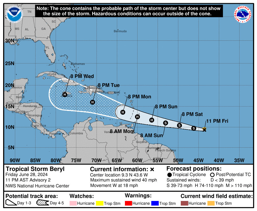
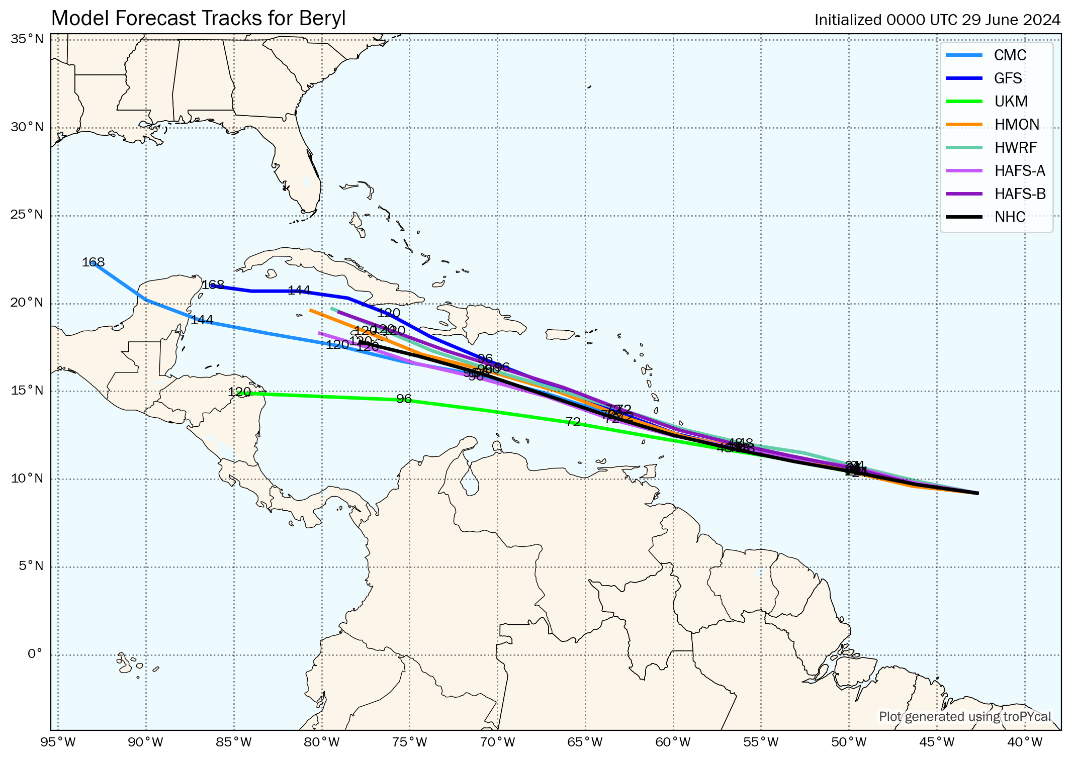
Forecast models show Tropical Storm Beryl being steered by a strong subtropical ridge to the north. This should keep Beryl moving swiftly westward to west-northwestward during the next few days, with the model guidance remaining tightly clustered as the system moves towards the Windward Islands, moving across the area on Monday, July 1st, 2024.
When the system moves into the Caribbean Sea, Beryl nears a weakness in the subtropical ridge. As a result, Beryl is forecast to track across the eastern and central Caribbean Sea
through the middle of next week.
As of Friday night, Tropical Storm Beryl poses a threat north of Tobago and across the southern and central Windwards, from Grenada to Martinique. Strong wind gusts are possible across the northern Windwards.
How strong could it get?
Development this far east in late June is unusual; in fact, only a few storms have formed over the central or eastern tropical Atlantic this early in the year. Typically, the atmospheric environment is unfavorable for intensification in this portion of the Atlantic basin in late June.
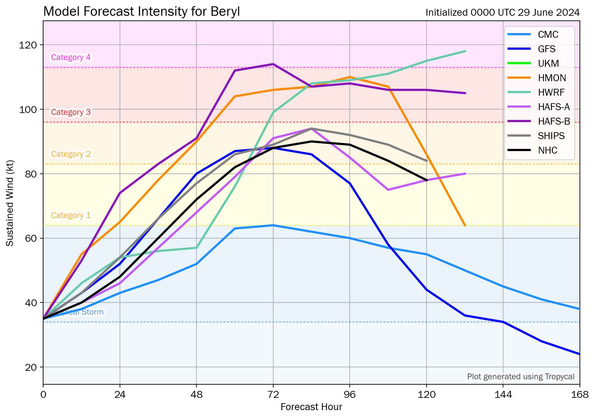
Atmospheric and oceanic conditions, atypical for this time of year, are fairly favorable for strengthening the next few days with warm sea surface temperatures, plenty of moisture, and low vertical wind shear. Accordingly, the official forecast calls for strengthening and shows the tropical storm becoming a hurricane before it reaches the Windward Islands.
It should be noted that some of the model guidance is still quite aggressive and a fair amount are even higher than the official forecast. Some hurricane regional models and consensus aids show the system becoming a major hurricane prior to reaching the Windward Islands.
The 00Z SHIPS guidance shows a 10.3 times chance, based on climatology, of rapid intensification, increasing 65 knots in 72 hours before it reaches the Windward Islands. A number of hurricane models show that if an eye/eye wall can develop early, a powerful hurricane is possible as it nears the Windwards on Monday. The official forecast from the National Hurricane Center has a Category 2 hurricane with maximum sustained winds of 150 KM/H to 165 KM/H and higher gusts.
What does this mean for the Lesser Antilles?
Tropical Storm Beryl is expected to strengthen and be a hurricane when it reaches the Windward Islands late Sunday night or Monday, bringing a risk of heavy rainfall, hurricane-force winds, and dangerous storm surge and waves.
Hurricane and Tropical Storm Watches will likely be required for portions of the Windward and southern Leeward Islands early Saturday.
Tropical cyclone preparedness plans should be reviewed for the southern and central Lesser Antilles. There is an increasing risk of heavy rainfall that will produce floods, landslides, and mudslides, as well as strong winds and gusts that can cause wind damage and rough seas.
Wind
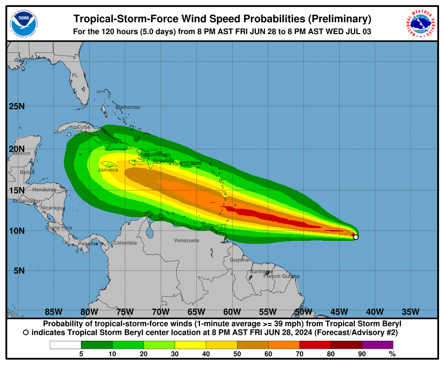
Based on the latest guidance, tropical storm-force wind gusts, and sustained winds (above 34 knots, 39 MPH, 63 KM/H) are forecast to primarily affect the Windwards. This includes from Grenada through Dominica, and Tobago, with isolated strong gusts northward in isolated heavy showers or thunderstorms.
For T&T, generally, light to near-calm winds are likely across the country on Sunday night through Monday afternoon, outside of feeder band activity. From Monday night through Tuesday morning and in feeder band activity, the pressure gradient between the low-pressure system north of T&T and a high-pressure system over northern South America will lead to strong low-level southeasterly winds across the area. These winds can reach the surface in showers or thunderstorms. Wind gusts exceeding 45 KM/H are likely during this period, and gusts up to 60 KM/H are possible.
Rainfall
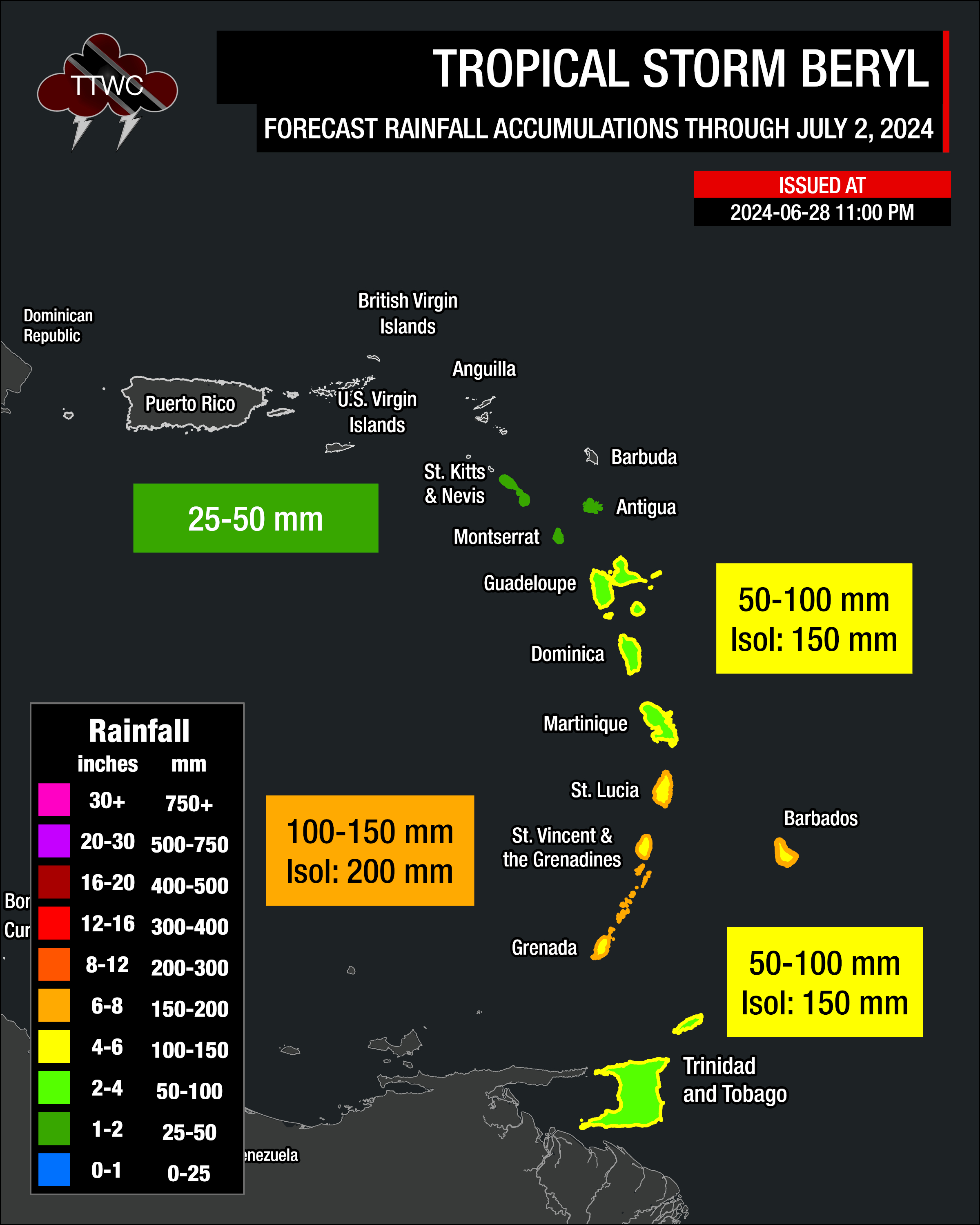
The highest rainfall accumulations are forecast to occur between Grenada and St. Lucia, including Barbados. Rainfall totals through Tuesday, July 2nd, 2024, will range between 100 and 150 millimeters (4-6 inches), with isolated totals up to 200 millimeters (8 inches).
Across the remainder of the central Windwards, between 50 and 100 millimeters (2-4 inches) of rainfall is likely, with isolated totals up to 150 millimeters (6 inches) favoring windward (eastern) coastlines.
Trinidad and Tobago will likely experience between 50 and 100 millimeters (2-4 inches) of rainfall, with isolated totals up to 150 millimeters (6 inches) favoring windward (eastern) coastlines.
For the southernmost Leewards, rainfall totals are forecast to be as high as 25 millimeters (1 inch), with isolated totals of up to 50 millimeters, favoring southern and eastern coastlines.
Seas and Storm Surge
The strongest winds associated with the eventual Hurricane Beryl are forecast to remain north of the center of circulation, leading to the higher waves and swells affecting the southern and central Windwards. However, due to the large spread of intensity models, there is also a spread of wave models as well.
Based on the latest model guidance, waves south of Guadeloupe and north of Tobago are forecast to be above 3.5 meters. Peak waves are forecast to occur north of Tobago and south of Martinique, with peak heights ranging from 4.5 meters to 10 meters in open waters. The Barbados Meteorological Service is forecasting waves as high as 6 meters near their area of responsibility.
For T&T, rough seas are likely on Monday and Tuesday, mainly along the country’s eastern and northern offshore areas, with waves 2.5 and 3.5 meters in open waters, occasionally higher in northeastern waters.
Again, this is based on current track and intensity guidance, which can change in the coming days.
For Trinidad and Tobago
For Trinidad and Tobago, given this system is forecast to generally remain north of the country, feeder band activity poses the most risk, with locally heavy rain, accompanied by potentially damaging wind gusts. Stronger southerly winds may also lead to isolated thunderstorms being enhanced by topography, and with near-calm to light winds mainly on Monday and with clockwise turning winds through the atmosphere, the potential for funnel clouds will also exist. Rough seas are also likely, mainly in northern and eastern coastal waters.
On Monday evening through Tuesday morning, with southerly to southwesterly winds, strong evening thunderstorms may also move off the Venezuelan coastline south of Trinidad and move toward the country in the Gulf of Paria, creating hazardous marine conditions and producing frequent, dangerous lightning.
Latest Weather Forecast For T&T

Wet Easter Weekend Forecast For T&T
Pay close attention to official forecasts in the coming hours and days from your respective authorities. For Trinidad and Tobago, official forecasts and early warnings come from the Trinidad and Tobago Meteorological Service.