


Invest 95L continues to organize and become better-defined east of the Windward Islands, approximately 2,400 kilometers east of Trinidad and Tobago and is forecast to bring heavy rainfall, strong winds, and rough seas to the region from as early as Sunday night.
Then, the National Hurricane Center has tagged a new tropical wave for development even further east of Invest 95L. This wave may bring a one-two punch to the region, as forecast models show it taking a similar path to Invest 95L next week.
What you need to know
— Invest 95L: A robust tropical disturbance is likely to be designated as a tropical depression or tropical storm later today or tomorrow, east of the Windwards. It is forecast to bring heavy rainfall, strong winds and rough seas to the Windwards, including T&T and Barbados, from as early as Sunday night.
— Tropical Wave 17: The National Hurricane Center has tagged this tropical wave for development, with chances low over the next seven days. Forecast models show it taking a similar path to Invest 95L, moving across the Windwards, including T&T and Barbados, by Wednesday.
— Latest from officials: Across the island chain, there are no alerts, watches, or warnings. However, several meteorological offices have issued statements on the system.
Invest 95L

The National Hurricane Center (NHC), in their 8:00 AM Tropical Weather Outlook, now has development chances at 90% (high) over the next 48 hours and seven days, respectively. With showers and thunderstorms showing signs of organization, the National Hurricane Center says, “A tropical depression or tropical storm will likely form later today or on Saturday.”
The next name on the 2024 list is Beryl. The general forecast movement has not changed, with the system moving west-southwest today, and by tomorrow, taking a more west-northwestward path.

An upper-level high-pressure system is accompanying the system as it moves west, providing an unusually favorable environment for development. Sea surface temperatures are also running at record highs. The only limiting factors will be its proximity to dry air, particularly as it gains strength and begins to move more west-northwestward and easterly wind shear.
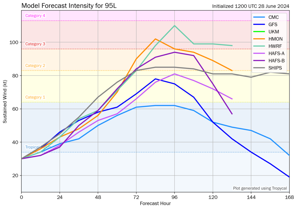
12Z Friday, June 28th, 2024, deterministic and hurricane model guidance for Invest 95L, showing a tropical storm is likely from the top leading global and hurricane models. (Tomer Burg)
Forecast models show Invest 95L becoming a tropical storm within the next 24 hours and making a run at hurricane status by Sunday afternoon. Concerningly, the SHIPS and dynamical models show that chances for rapid intensification are approximately 7.5 times the climatological average for a tropical cyclone, increasing 65 knots inside a 72-hour period.
While there are no alerts, watches, or warnings in effect at this time, those living or having interests in the Windwards between Grenada and St. Lucia, including Barbados, should begin preparing for strong winds, rough seas, and heavy rainfall. Trinidad and Tobago will remain on the southern side of the circulation but are by no means fully in the clear, as outer bands, showers, and thunderstorms remain forecast.
According to hurricane specialist Michael Lowery, The development of a tropical storm this far east in the tropical Atlantic is uncommon, though not unprecedented. Only five named storms on record have formed in the tropical Atlantic east of the Caribbean (only about 5% of all named storms developing in June), including Bret and Cindy last June. Bret brought tropical storm conditions to much of the Windward Islands, but both Bret and Cindy fell short of becoming hurricanes. Only one hurricane on record has ever been recorded east of the islands in June – the 1933 Trinidad Hurricane.

A new tropical wave

Forecast models have repeatedly shown the development of a system trailing Invest 95L, and early Friday morning, the National Hurricane Center formally tagged it for development.
Models are not enthusiastic about its development, keeping it as a strong tropical wave as it moves across the Atlantic or a borderline tropical cyclone (either a depression or storm) as it trails Invest 95L and moves across the Windwards by Wednesday.
At this time, its development chances and intensity depend on the eventual intensity of Invest 95L, as the outflow from Invest 95L will disrupt the development of this wave by imparting wind shear. Additionally, this tropical wave, based on current model guidance, will have to deal with more dry air than Invest 95L. Regardless, current models suggest the same areas affected by Invest 95L from Sunday night through Tuesday morning, will be affected by this system on Wednesday.
We’ll have our in-depth update later this evening, or sooner if advisories begin on Invest 95L.


