


Following last night’s magnitude 6.2 earthquake northwest of Trinidad, which was widely felt across the Windward Islands and northeastern South America, multiple aftershocks continue to be recorded.
Both the University of the West Indies Seismic Research Centre (the authority for T&T and the English-speaking Eastern Caribbean) and the Venezuelan Foundation for Seismological Research have recorded minor to light quakes deep below the Paria Peninsula.
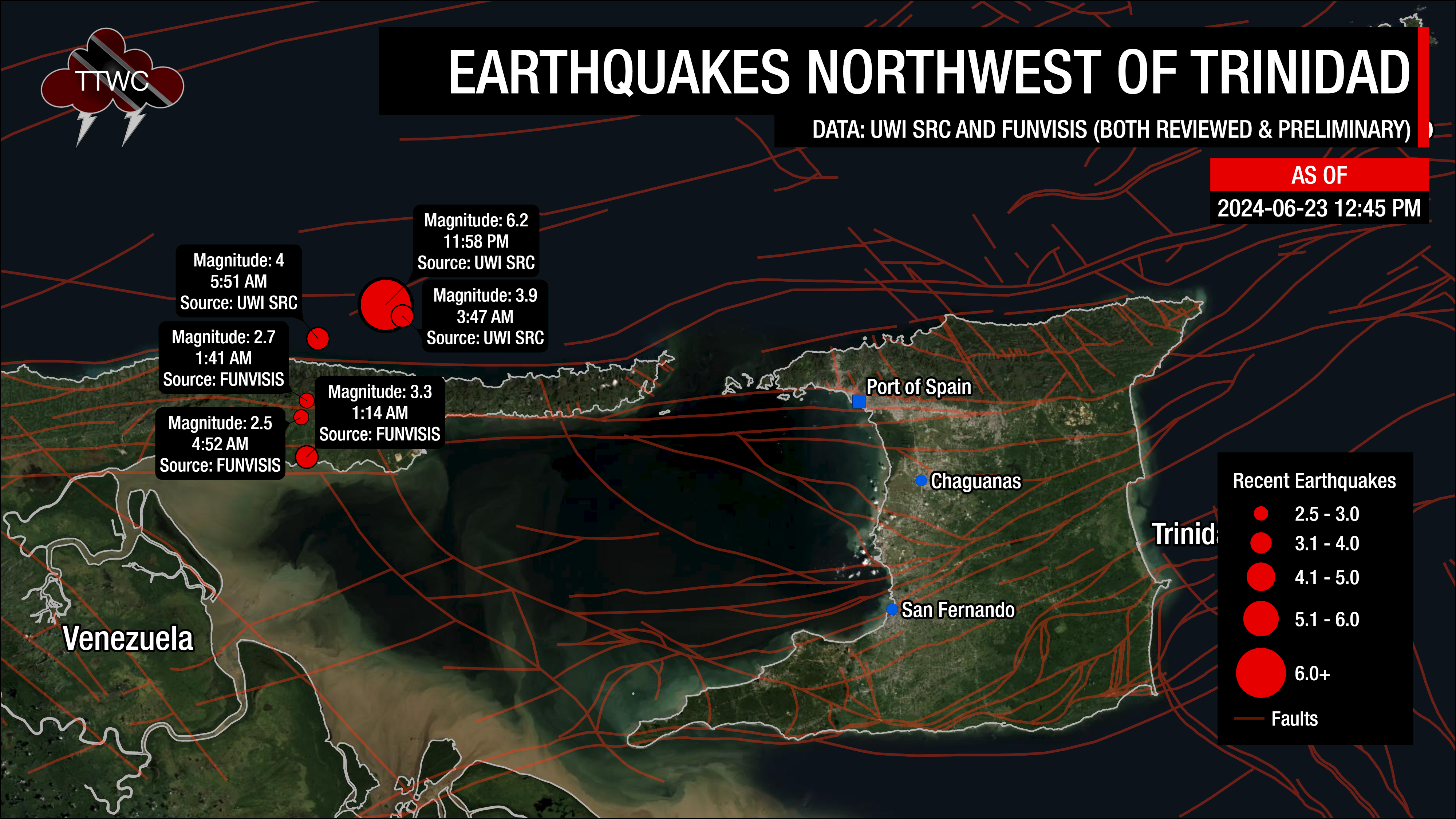
According to the UWI SRC, the largest of the six aftershocks (greater than magnitude 2.5) occurred at 3:47 AM and 5:51 AM, registering magnitudes of 3.9 and 4.0, respectively. Since 11:58 PM Saturday, over 20 aftershocks have been recorded northwest of Trinidad through 5:30 PM Sunday. All of these quakes have not been reported felt, generally minor, and are occurring approximately 90 to 110 kilometers west-northwest of Port of Spain, at depths between 30 and 90 kilometers below ground.
Saturday night’s magnitude 6.2 earthquake produced moderate to strong shaking across parts of Northeastern Venezuela and Northwestern Trinidad, moderate shaking across Trinidad, with weak to light shaking elsewhere. Preliminary ground shaking data from the UWI SRC shows that parts of northwestern Trinidad, namely in Mucurapo, St. James, saw peak ground acceleration as strong as 0.2g – which is indicative of very strong ground shaking and capable of producing moderate damage. There were no reports of damage or injuries, but parts of northern and northwestern Trinidad experienced power outages shortly after the earthquake.
Many drew comparisons to the August 21st, 2018 earthquake, which registered magnitude 6.9 on the Richter Scale. Earthquake magnitudes are logarithmic, meaning as the earthquake magnitude increases, the energy released by the quake increases exponentially, which leads to longer and more intense shaking. For comparison, Saturday night’s M6.2 quake produced shaking for 30 to 35 seconds, while the August 2018 earthquake rocked T&T for 90 seconds, and the 0.7 difference in magnitude meant that the 2018 earthquake was 5 fives stronger and released 11 times more energy.
While none of the aftershocks have been reported felt, this activity is normal following larger earthquakes and can continue for days, weeks, months and even years after the initial quake.
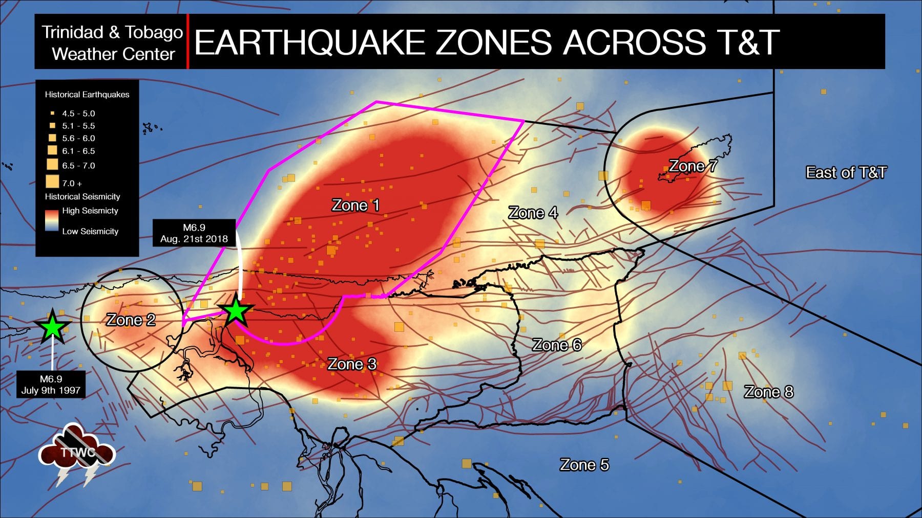
Seismic zone one is a complex and, without a doubt, the most seismically active area near Trinidad. According to the UWI SRC, this area is the second most seismically active area in the Eastern Caribbean and has generated major to great earthquakes in historic times.
The 1766 magnitude 7.9 event, estimated to have been located in this area, destroyed the then Capital of San José. The 1888 magnitude 7.5 event was damaging from Trinidad to St. Vincent. The largest event for the instrumental period, i.e., since 1952, occurred on September 20th, 1968, and was of magnitude 7.0. Significant damage was caused in Venezuela, and Trinidad, where there was damage in Port of Spain.
In this area, the South American plate is beginning to descend rapidly into the Earth’s mantle as the detached oceanic lithosphere exists at depths between 50 to 300 kilometers within zone one. (Russo et al. 1993).
At shallower levels, the North Coast Fault Zone and the El Pilar Fault, part of the Boconó-San Sebastian-El Pilar Fault system, run across Zone 1. These fault systems compensate for the stress built up as the Caribbean plate slides past the South American plate. Hence, most of these earthquakes from these fault systems occur at shallow to moderate depths between 0 and 70 kilometers.
The UWI SRC says approximately 65 events of magnitude 2.1 and above are located in the area annually.
Based on the historical and instrumental seismic records, more than 2,400 earthquakes have been recorded within 20 kilometers of Saturday night’s event. However, within the historical record, the largest event was the magnitude 6.0 earthquake that struck on October 11th, 2013. Quakes near the event’s hypocenter have typically occurred at depths between 50 and 125 kilometers.
On average, the Eastern Caribbean has seen a pattern of major (M7.0-M7.9) quakes every 20 to 30 years. That pattern has stayed true. The last major (M7.0-7.9) quake occurred north of Martinique in 2007.
Historical patterns indicate that great quakes (M8.0+) on the Richter Scale have occurred every century in the region. The probability of another event at that level is high since the last >M8.0 earthquake occurred in 1843. While it is impossible to say definitively when the next great quake will occur in the region, the time since the last one is now more than 170 years ago.
It is important to note that seismic activity cannot be predicted—meaning the precise time, date, magnitude, depth, etc., cannot be known ahead of time based on current research and technology.
Now is the time to create or go over your earthquake preparedness plan and know what to do during, before, and after an earthquake.
Read More

In our region, earthquakes can strike at any time and any place, so it is important to know how to keep yourself safe when one strikes.


