


The 2024 Wet Season is forecast to be an overall near to above-normal season when it comes to rainfall for Trinidad and Tobago. For the next six months, Trinidad and Tobago will experience periods of rainfall associated with tropical waves, the Intertropical Convergence Zone, and even tropical cyclones. All the rainfall won’t arrive at once, but here’s what you should know for the next several months.
A Near- To Above-Normal Rainfall To Kick Off Wet Season

The Trinidad and Tobago Meteorological Service (TTMS) is forecasting near- to above-average rainfall totals across much of the country for June 2024 in their updated outlook, issued on May 21st, 2024.
In the latest outlook, the TTMS says that the 2024 Wet Season is likely to begin with wetter-than-usual conditions across the country. They add that there is a 42% to 63% chance for above-normal rainfall in June for western areas of Trinidad and eastern areas of Tobago, with other areas near normal.
Read More

TTMS: June 2024 Likely To Have Near- To Above-Normal Rainfall
Near- to Above-Normal Rainfall Overall For the 2024 Wet Season
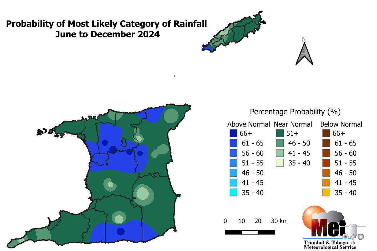
The 2024 Wet Season is forecast to end with near- to above-average rainfall totals across most of the country. As we progress through the remainder of 2024, rainfall is expected to decrease across some parts of the country. Overall, probabilities are greater than 51% for near-normal accumulated rainfall totals across Trinidad and Tobago for the 2024 Wet Season.

Through August, the first half of the Wet Season, the Met Office is also forecasting near- to above-normal rainfall totals in most areas. Additionally, the TTMS forecasts a 51% chance of above-normal rainfall across Trinidad’s northern and western halves between June and August, as well as much of Tobago, which may lead to high chances for flash flooding during heavy and/or prolonged rainfall events.

From August through October, however, there is a greater than 51% chance of near-normal rainfall across both countries. However, pockets will receive above-normal rainfall totals, favoring southern and western areas of Trinidad.
Generally, above-average rainfall totals are forecast across both islands, with pockets of near-average rainfall across southwestern Trinidad and leeward areas of Tobago.
Near-Normal Still Means Wet Conditions Expected
Although the TTMS is forecasting near-average rainfall overall, periods of heavy rainfall are still likely.
For 2024, overall, the TTMS says there is a 52% chance of an above-normal number of heavy rainfall days (where T&T receives above 25 millimeters of rainfall), with the likely range of heavy rainfall days between June and December between 11 and 22. The average number of heavy rainfall days is 16.
However, when looking at extreme or extremely heavy rainfall days (where T&T receives upwards of 50 millimeters of rainfall), there is a 43% chance of 2 to 6 extremely heavy rainfall days, compared to the normal four days. According to the TTMS, there are at least five days where daily rainfall accumulations could exceed 75 millimeters.
Isolated heavy rainfall or extremely heavy rainfall days can be temporarily disruptive, but for longer-lasting riverine flooding to occur, rainfall will need to persist over several days. For 2024, the TTMS is forecasting a 53% chance of above-normal three-day wet spells, where they expect 5 three-day wet spells compared to the normal of 4 three-day wet spells. The TTMS says the 2024 Wet Season is likely to have 49 wet days, where T&T records 10 millimeters of rainfall or more, compared to the normal 47 wet days.
For those wary of prolonged flooding, the TTMS is also forecasting a 73% chance of one five-day wet spell – or five consecutive days where T&T records at least 10 millimeters of rainfall. Between 1991 and 2020, on average, the Wet Season has one five-day wet spell period.
High flood risk potential

The Met Office indicates that flooding is expected to worsen and expand across the country as the 2024 Wet Season progresses.
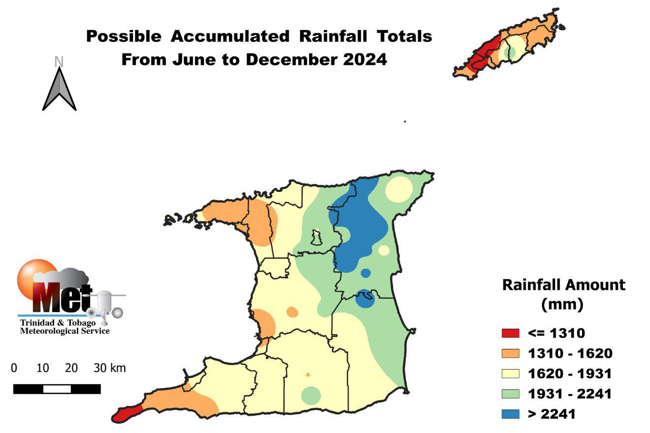
They are forecasting accumulated rainfall totals above 1,000 millimeters across the Leeward side of Tobago and areas of the southwestern coast of Trinidad over the next six months. Higher rainfall accumulations near 2,560 millimeters in northeast Trinidad, in the vicinity of Sangre Grande, Vega De Oropouche, Plum Mitan, and environs, are also forecast. In Tobago, areas near Mt. St. George and Goodwood are forecast to receive nearly 2,000 millimeters of rainfall from June through December.
In their 2024 Wet Season Flood Potential Outlook, the TTMS states, “Flood potential is moderately higher than normal across other well-known flood-prone areas in northeast, northwest, and southern Trinidad and Tobago.” Meanwhile, central-west and southeast Trinidad have slightly higher than normal flood potential, according to the TTMS.
Last year, 126 communities were highlighted for their above-normal potential for flooding. This year, that total stands at 181. For comparison, in 2022, 81 communities were highlighted for their above-normal potential for flooding
Read More

2024 Wet Season: Higher-than-usual Flood Potential In 181 Communities
Warmer-than-average temperatures expected

The (TTMS) is forecasting yet another Wet Season with above-average temperatures. For the 2024 Wet Season, the TTMS says there is a 40% to 65% chance for maximum day temperatures and minimum nighttime temperatures to be above average favoring western areas of Trinidad and Tobago.
In Trinidad and Tobago, the local heat season has its peak from August through October, and the TTMS is forecasting maximum temperatures to reach or exceed 34.0°C during this time. There are also elevated chances for short-duration hot spells and “heat surges” where maximum temperatures reach or exceed 34.0°C during September and early October, with the highest risk in late August and early October.
Read More

2024 Wet Season: More Hot Temperatures In The Forcast
What should you do?
- Strengthen community coordination with disaster management personnel.
- Persons living in flood-risk areas should quicken their flood planning and preparedness efforts.
- Purchase emergency supplies, pack a grab-and-go bag with clothes and essentials, and have these on standby.
- Get acquainted with your flood-prone areas and shelter locations and become sandbag-ready.
- Develop an evacuation plan that outlines the safety of family members and pets.
- Update contact information for the local disaster officials and other emergency services.


