Heavy rainfall is forecast this weekend across the Eastern Caribbean, from as south as Trinidad and Tobago to as north as the Leeward Islands, associated with a tropical disturbance east of the region.
While development chances remain low, favorable conditions will support periods of heavy showers, thunderstorms, and occasional gusty winds throughout the island chain through Monday.
What you need to know
— What has happened: A tropical wave, interacting with the Monsoon Trough (like the Intertropical Convergence Zone), is producing disorganized showers and thunderstorms, with an area of low pressure forecast to form sometime this weekend.
— Where is it forecast to move: Forecast confidence has increased, with the wave moving through the Eastern Caribbean on Sunday, though much of the heaviest rains are forecast to move through the central Lesser Antilles.
— The Intensity & Impacts: This large and strong tropical wave is forecast to produce rainfall amounts between 50 and 100 millimeters from Trinidad and Tobago to Barbuda between Saturday and Monday, with higher amounts between 50 and 150 millimeters from Grenada to Guadeloupe in the same time period. Isolated totals, particularly in hilly, windward-facing slopes, could exceed 150 millimeters in the 72-hour period. Stronger wind gusts are forecast to remain north of Barbados and St. Vincent, where gusts could exceed 65 KM/H and reach as high as 80 KM/H.
— Latest from officials: Across the island chain, there are no tropical storm watches or warnings. However, several meteorological offices, like T&T‘s and Barbados, have issued statements on the system.
The latest
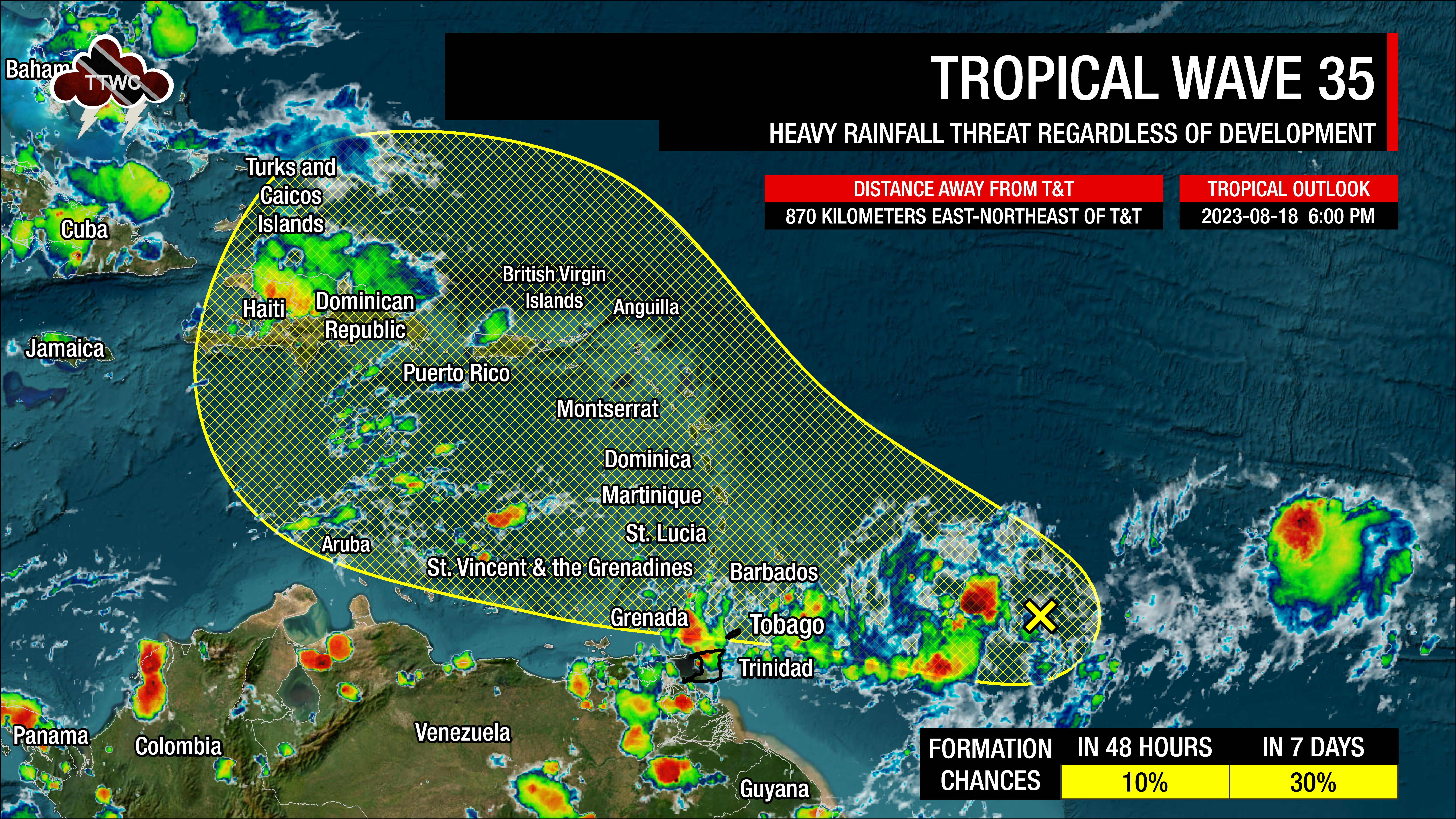
At 6:00 PM Friday, August 18th, 2023, the axis of Tropical Wave 35 and the approximate center of a broad low-pressure area was located along 54°W, placing it approximately 870 kilometers east-northeast of Trinidad and Tobago
According to the National Hurricane Center’s 2:00 PM Tropical Weather Outlook, “An area of low pressure could form in a day or so from an elongated trough of low pressure located several hundred miles to the east-southeast of the Lesser Antilles.”
The add that some slow development of this system is possible over the weekend and into early next week as it moves generally west-northwestward at 10 to 15 MPH (16-26 KM/H) across the Lesser Antilles and into the northeastern Caribbean Sea.
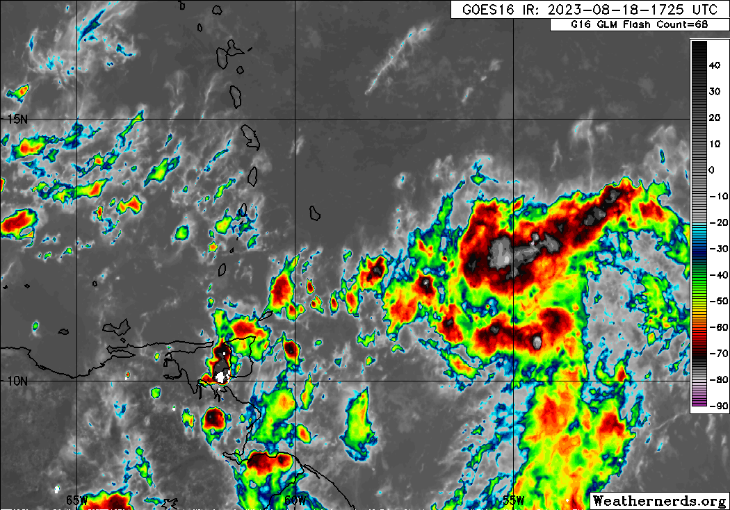
This trough is producing scattered showers and thunderstorms east of Trinidad, Tobago, and the Windward Islands with widespread cloudiness. It is also located in a pocket of favorable upper-level divergence, low-level convergence, and a narrow area of light to moderate wind shear. Sea surface temperatures are between 29°C and 30°C with anomalously high atmospheric moisture.
Current Alerts, Watches, Warnings

For Trinidad and Tobago, officially from the Trinidad and Tobago Meteorological Service, there are no alerts, watches, or warnings in effect for the country based on the latest official statement and their Early Warning System page. However, in their official Public Weather Forecast at 4:00 PM Friday, gusty winds and street/flash flooding are possible in heavy showers/thunderstorms.
Barbados has yellow-level alerts for excessive rainfall between August 19th through August 20th and for small craft between August 19th and 20th. In their official statement on the system on Friday evening, they add that flash flood watches or warnings may be issued for the country at short notice.
Grenada’s Meteorological Service has the country and its dependencies under an alert for flash flooding and landslides.
St. Vincent and the Grenadines Met Service has the country under orange-level weather warnings for heavy showers and thunderstorms and a marine warning for large waves. They add that flash flood watches/warnings may also be issued this weekend.
The St. Lucia Met Service has advised of locally rough seas, leading to a small craft advisory on Friday evening.
A small craft advisory is also in effect for Dominica, with their Met Service advising that a flood watch or warning may be issued this weekend.
Both Martinique and Guadeloupe are under yellow-level alerts for heavy rainfall and strong winds from August 19th through early August 22nd.
There are no tropical storm watches or warnings in effect for the Lesser Antilles, including T&T.
What could be the impacts?
Favorable upper-level conditions are forecast to enhance showers and thunderstorms across the island chain, leading to flooding rainfall, agitated seas, and gusty winds. Fallen trees, landslides/mudslides, and power outages with coastal, street, and flash flooding are possible.
Wind

As with all strong tropical waves, the strongest winds remain across the northern portion of the wave axis. In this case, the northern half of the axis extends north of St. Vincent and Barbados to the Leewards. Across these islands, winds are likely to reach up to 50 KM/H and gusts as high as 80 KM/H, particularly in heavy showers, thunderstorms, and hilly terrain on windward or Atlantic-facing slopes.
For Grenada and T&T, sustained winds can reach as high as 40 KM/H and gust to 55 KM/H, particularly in heavy showers and thunderstorms. Locally higher gusts are possible in strong thunderstorms as a result of upper-level support, particularly on Sunday.
When strong low-pressure systems (strong tropical waves, tropical storms, or even hurricanes) move sufficiently north of T&T, the winds across Trinidad and Tobago become light to near-calm as the pressure gradient across the area slackens. This will occur on Saturday, with stronger southerly to southeastern winds on Sunday through early Tuesday, leading to faster-moving showers and thunderstorms, moving from the south/southeast to north/northwest.
Rainfall
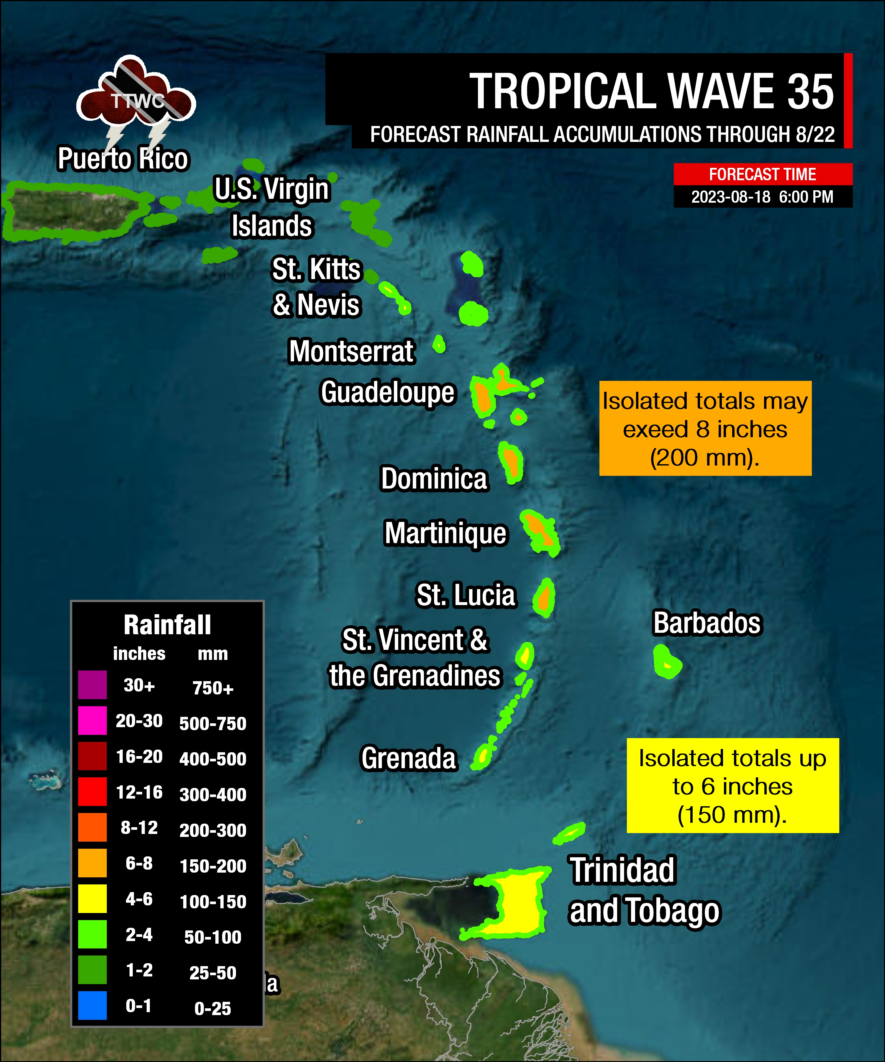
The highest rainfall accumulations are forecast to occur across St. Lucia to Guadeloupe, with rainfall totals through Tuesday, August 22nd, 2023 ranging between 50 and 100 millimeters (2-4 inches) with isolated totals up to 200 millimeters (8 inches).
For Barbados, St. Vincent and the Grenadines, Grenada, and T&T, rainfall totals are forecast between 50 and 100 millimeters (2-4 inches) and isolated totals up to 150 millimeters (6 inches), favoring windward/Atlantic-facing coastlines and south-facing slopes.
Seas and Storm Surge
Forecast models are showing waves in open waters are forecast to exceed 2.5 meters (8 feet) and up to 4.0 meters (12 feet) near east-facing coastlines north of Barbados to Guadeloupe. For areas between islands, waves can reach as high as 4.0 meters (13 feet) near coastlines and higher in open waters. These higher seas are forecast to remain well north of Trinidad and Tobago, with hazardous seas likely from St. Vincent and the Grenadines, as well as Barbados northward. For T&T, seas are forecast to remain moderate with open waters waves occasionally up to 2.5 meters this weekend into early next week.
For Trinidad and Tobago
In nearly all forecast model guidance as of 6:00 PM Friday, August 18th, 2023, Tropical Wave 35’s worst impacts remain north of Trinidad and Tobago.
As the system nears on Saturday, convergence ahead of the low-pressure trough area, with winds coming from the northeast to north, showers, and thunderstorms will initially move northeastward to southwestward across Trinidad and Tobago. Then, by late Saturday through Sunday, as the wave moves into the Caribbean Sea, southerly to southeasterly wind flow feeds into the tropical wave with showers and thunderstorms trailing, moving across Trinidad, Tobago, and the Windwards again.
On Saturday, particularly during the late morning through afternoon, due to slack to near-calm winds, localized climatic effects like daytime heating, sea breeze convergence, and orographic effects take over, producing slow-moving showers and thunderstorms that are enhanced by topography. These effects can trigger locally heavy rainfall, producing street/flash flooding, gusty winds, and other hazardous weather impacts in localized areas. Additionally, with southerly winds prevailing Saturday evening into Sunday, thunderstorm activity from northern Venezuela may drip toward Trinidad, particularly within the Gulf of Paria and near south Trinidad, leading to agitated seas and heavy rainfall.
Pay close attention to official forecasts in the coming hours and days from your respective authorities. For Trinidad and Tobago, official forecasts and early warnings come from the Trinidad and Tobago Meteorological Service.