A strong earthquake struck north of the Leeward Islands on Monday afternoon with a very small possibility of tsunami waves for the coastlines of the Leewards and Greater Antilles. There is no significant tsunami threat for Trinidad, Tobago, and the Eastern Caribbean.
What you need to know
— The Earthquake: According to the United States Geological Survey (USGS), the quake registered a magnitude of 6.6 (Mww) on the Richter Scale, striking at a depth of 10 kilometers 43 kilometers 278.7 KM NNE of Codrington, Antigua and Barbuda. Light shaking has been reported across the Leewards and Greater Antilles. This is approximately 1,000 kilometers north of Trinidad and Tobago, so no shaking is likely across the southern Windwards.
— Tsunami Threat: According to the Pacific Tsunami Warning Center’s first Tsunami Information Statement issued at 4:34 PM local time, there is no significant tsunami threat from this earthquake. However, the PTWC notes there is a very small possibility of tsunami waves along coasts located nearest the epicenter, meaning eastern Panama and northwestern Colombia. There is no significant tsunami threat for T&T and the eastern Caribbean.
— Recommended Actions: No action is required.

At 4:28 PM Monday, July 10th, 2023, the USGS recorded a strong earthquake of magnitude 6.6 (Mww) approximately 278.7 KM NNE of Codrington, Antigua, and Barbuda, which is approximately 1,000 kilometers west of Trinidad and Tobago.
The quake was located at 20.044°N and 61.083°W at a depth of 10.0 kilometers. Light shaking has been reported across the Leewards and Greater Antilles, from as west as Puerto Rico to as south as Guadeloupe. Given the distance away from T&T and the Windward Islands, shaking from this quake was not expected.
The Tsunami Threat
According to the Pacific Tsunami Warning Center (PTWC), which issues threat messages for the Caribbean region, there was no significant tsunami threat from this quake. In their Tsunami Information Statement, which is issued for the region when a quake of magnitude 6.5 or above strikes within the region that does not pose a major tsunami threat, they stated:
BASED ON ALL AVAILABLE DATA... THERE IS NO SIGNIFICANT TSUNAMI THREAT FROM THIS EARTHQUAKE. HOWEVER... THERE IS A VERY SMALL POSSIBILITY OF TSUNAMI WAVES ALONG COASTS LOCATED NEAREST THE EPICENTER.
While no islands across the Eastern Caribbean issued any advisories on the earthquake, the Barbados Meteorological Service issued a Tsunami Advisory for Barbados. The Barbados Meteorological Service utilizes a Tsunami Advisory for information purposes – meaning there is still no tsunami threat – but they issue one to prevent unnecessary evacuations.
There are four conditions necessary for an earthquake to cause a tsunami:
- The earthquake must occur beneath the ocean or cause material to slide within or into the ocean.
- The earthquake must be strong, with at least a magnitude of 6.5.
- The earthquake must rupture the Earth’s surface, and it must occur at a shallow depth – less than 70 kilometers below the surface of the Earth.
- The earthquake must cause vertical movement of the seafloor (up to several meters).
Conditions 1, 2, and 3 were met, but vertical movement was not significant to generate a damaging tsunami. The latest data shows that is quake occurred on a strike-slip fault, which produces little vertical motion.

In the event of a tsunami in Trinidad and Tobago, the tsunami warning focal point is the Office of Disaster Preparedness and Management, which will issue a tsunami advisory, watch, or warning, and it will be disseminated through the Trinidad and Tobago Meteorological Service’s CAP-compliant early warning system, as well as the newly-launched Public Alert Notification System (PANS).
Strong Shaking Remained Offshore

According to the USGS’s felt reports, light shaking was reported in Puerto Rico, the U.S. and British Virgin Islands, St. Kitts and Nevis, Antigua and Barbuda, Sint Maarten and St. Martin, Saba and St. Eustatius, and Guadeloupe.
However, the strongest shaking remained offshore, given the type of faulting associated with the quake and the depth of the earthquake.
Has there been an increase in seismic activity?

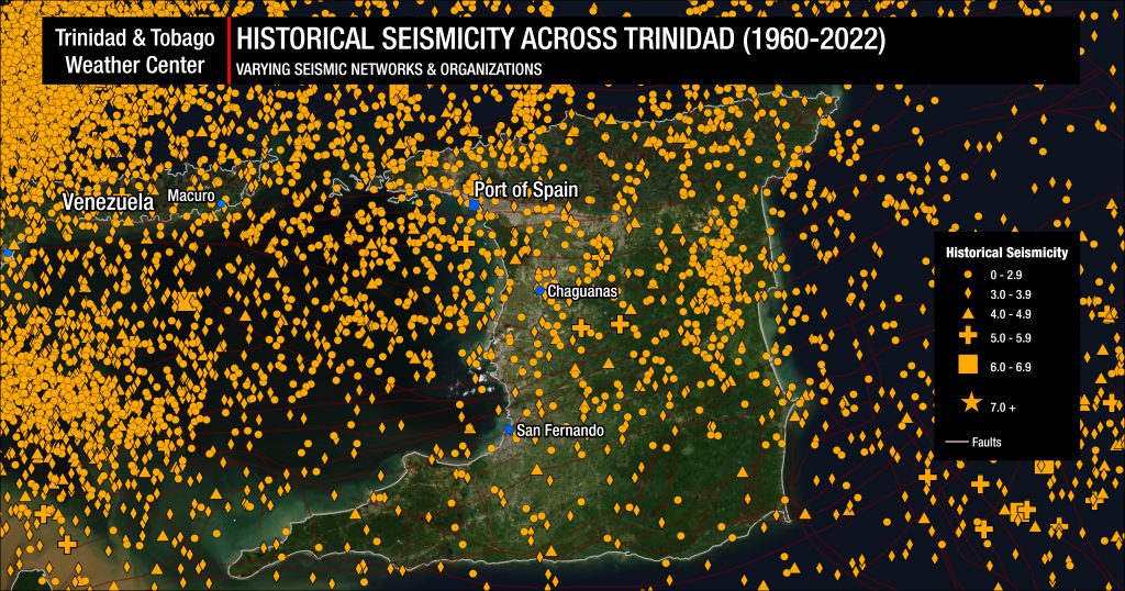
Trinidad and Tobago and the surrounding region are very seismically active. Across the Eastern Caribbean, over 2,200 earthquakes are recorded annually. Since 1990, the University of the West Indies Seismic Research Centre records an annual average of 280 earthquakes in the Trinidad and Tobago region (area bounded by 9.5°- 11.5°N & 59.5°W – 63.5°W). Of these 280 quakes, 50 of these seismic events are, on average, above magnitude 3.5.
Most earthquakes occur northwest of Trinidad in an area known as North of the Paria Peninsula, which has the second-highest seismicity in the Eastern Caribbean. According to the UWI SRC, approximately 65 events of magnitude 2.1 and above are located in the area annually.
However, the UWI SRC has said regional seismic and volcanic activity has been elevated for several years in their annual report for 2020 to 2021.
On average, the Eastern Caribbean has seen a pattern of major (M7.0-M7.9) quakes every 20 to 30 years. That pattern has stayed true. The last major (M7.0-7.9) quake occurred north of Martinique in 2007.
Historical patterns indicate that great quakes (M8.0+) on the Richter Scale have occurred every century in the region. The probability of another event at that level is high since the last >M8.0 earthquake occurred in 1843. While it is impossible to say definitively when the next great quake would occur in the region, the time since the last one is now more than 170 years ago.
It is important to note seismic activity *cannot* be predicted – meaning the precise time, date, magnitude, depth, etc., cannot be known ahead of time based on current research and technology.


