Two active and well-defined tropical waves are forecast to move across Trinidad and Tobago over the next five days, bringing periods of inclement weather, particularly from Friday night through Saturday and after midday Monday through Tuesday night next week.
What you need to know
— Rainfall: Forecast models indicate over the next five days, through Tuesday night, between 25 and 75 millimeters of rainfall are possible across both islands, with totals between 50 and 100 millimeters across the eastern half of Trinidad. Isolated rainfall accumulation could reach and exceed 150 millimeters in localized areas. As of Thursday evening, the wettest period is forecast on Monday afternoon through Tuesday.
— Saharan Dust: Decreasing concentrations of Saharan Dust is forecast on Friday through Saturday, with a brief surge on Sunday. Little to no dust is forecast on Monday and Tuesday.
— Hazards: Through late Tuesday, street/flash flooding and gusty winds are forecast to be the main hazards in heavy showers and thunderstorms. In and ahead of heavy showers or thunderstorms, sustained winds can reach 35 KM/H and as high as 45 KM/H on Monday into Tuesday. Wind gusts are expected to exceed 45 KM/H in heavy showers/thunderstorms, and from Monday, higher gusts to 55 KM/H are likely. There is the potential for landslides in elevated areas, particularly in areas that receive persisting rainfall, with areas across Tobago and northern Trinidad most at risk. Chances for riverine flooding increase on Monday night into Tuesday due to forecasted heavy rains.
— Marine: The overall sea state is forecast to remain moderate, with waves in open waters between 1.5 and 2 meters while in sheltered areas, below 1.0 meter through Sunday night. From Monday, seas are forecast to be agitated and moderate to rough, with waves in open waters ranging between 2.0 and 3.0 meters, while in sheltered areas, up to 1.5 meters.
Latest Alerts
TTMS Issues Adverse Weather Alert For T&T
Trinidad and Tobago is NOT under any tropical storm or hurricane threat, watch, or warning at this time.
The Forecast
Friday
FridaySaturday
SaturdaySunday
SundayMonday
MondayTuesday
TuesdayMarine Forecast
Slight to Moderate Seas Forecast For T&T
Temperatures
Temperatures are forecast to be hot on Friday, trending cooler than average from Saturday through Tuesday as a result of increased cloud cover across the country.
Wednesday through Sunday
Low: 24-27°C
High: 29-32°C
Maximum high temperatures are forecast to range between 29°C to 32°C, with higher temperatures across urbanized areas of Trinidad, where in built-up areas, maximum high temperatures could exceed 32°C on Friday. Minimum lows are forecast to remain mild, ranging between 24°C and 27°C in Trinidad and Tobago, trending cooler in interior areas. The heat index will generally be near or above 34°C on Friday, and cooler through the weekend into next week.
Forecast Impacts
Flooding
FloodingForecast Rainfall Totals
- Friday: Little to no rain is forecast across the country, with isolated totals up to 5 millimeters through 8 PM. From 8 PM onwards, isolated heavy showers and thunderstorms could produce localized totals favoring eastern areas of both islands up to 20 millimeters.
- Saturday: Between 5 and 15 millimeters of rainfall across both islands, with totals between 15 and 25 millimeters across Tobago, the eastern half of Trinidad, as well as localized areas along western coastal Trinidad.
- Sunday: Between 5 and 15 millimeters of rainfall across both islands, trending higher across eastern Trinidad and western coastal areas with isolated totals between 15 and 25 millimeters. In heavy showers/thunderstorms, 24-hour totals may exceed 25 millimeters.
- Monday: During the first half of the day, little to no rainfall is forecast. Nearing the late morning (9 AM) onward, between 5 to 15 millimeters of rainfall is forecast across both islands, with totals ranging between 15 and 35 millimeters across eastern Trinidad and western coastal areas. After 8 PM, heavy showers and thunderstorms are likely, which can produce higher rainfall totals in localized areas.
- Tuesday: This is forecast to be the wettest day of the five-day period. Between 10 to 25 millimeters of rainfall is forecast across the country, with rainfall totals ranging between 25 and 50 millimeters across the eastern half of Trinidad. In isolated areas, particularly across the eastern half of Trinidad, higher rainfall totals are possible.
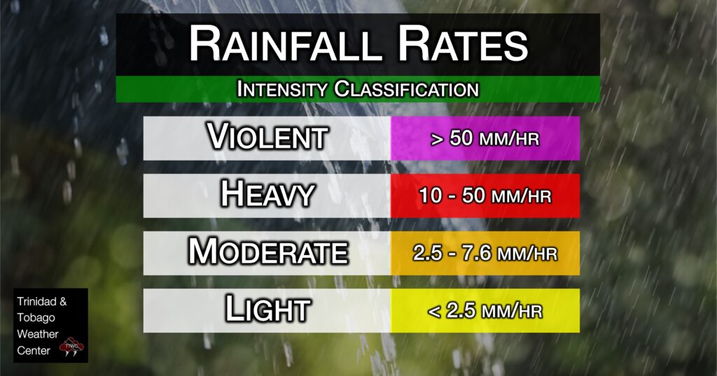
Understanding Rainfall Rates

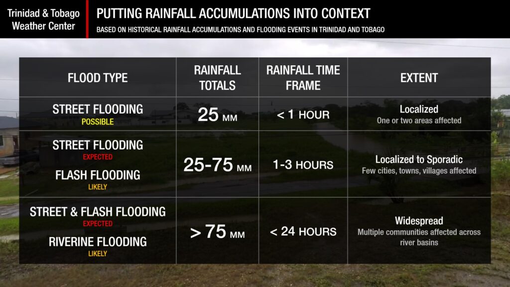
Understanding Rainfall Accumulations
Putting the rainfall forecast into context, rainfall rates in excess of 50 millimeters per hour or areas that receive in excess of 25 millimeters within an hour tend to trigger street flooding across the country or flash flooding in northern Trinidad. For riverine flooding to occur, a large area of the country (not just in highly localized areas of western coastal Trinidad) would have to record upwards of 75 millimeters within 24 hours, and rainfall would have to fall across major rivers’ catchment areas.

Strong Thunderstorms
Strong ThunderstormsWhat is a strong or severe thunderstorm?
Given how rare these types of thunderstorms are in our region – we classify a severe or strong thunderstorm as one that produces any of the following:
- Damaging wind gusts exceeding 55 KM/H;
- Frequent lightning (more than 30 cloud-to-ground strikes within a 10-minute period);
- Hail (of any size);
- Rainfall of more than 50 millimeters or more within an hour or exceeding 75 millimeters or more within three hours;
- The sighting of a funnel cloud or touchdown of a waterspout/tornado associated with the thunderstorm.
Gusty Winds
Gusty WindsPossible impacts, particularly on Monday and Tuesday, include localized wind damage to trees, power lines, and small structures. Small potted plants may blow over with light outdoor objects becoming airborne in stronger gusts. Tents may jump. Localized power outages are possible.
Other Hazards
Saharan Dust Forecast
Dust-Free Days Ahead For T&T As Saharan Dust Stays North
Why I May Not/Will Not See Rainfall?
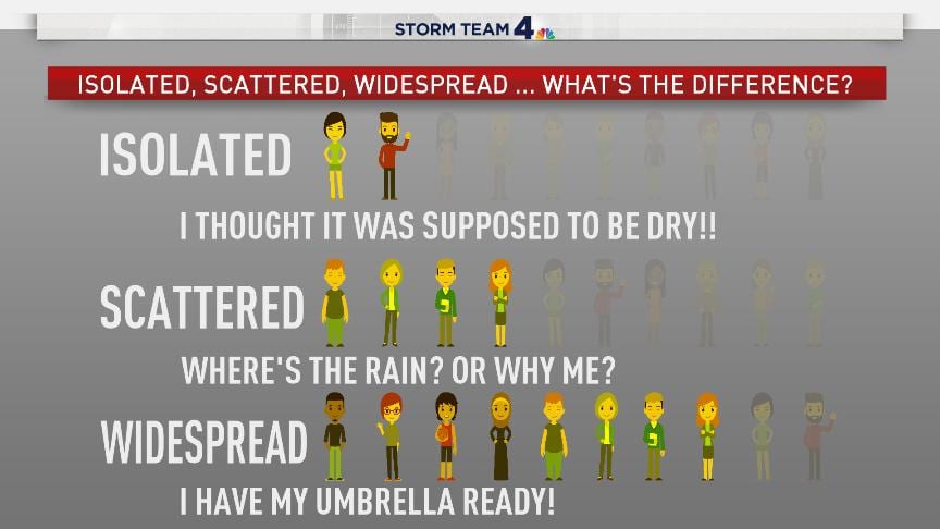
A frequent complaint is the forecast is wrong because I didn’t experience any rainfall. Scattered showers mean that you, individually, may experience some showers intermittently throughout the day, and there is a higher chance for this activity than isolated activity. Widespread showers mean that nearly all persons and areas may experience rainfall.
On Friday, highly isolated showers are possible, with isolated to scattered rainfall on Sunday. On Saturday and again on Monday into Tuesday, scattered to widespread rainfall is forecast across the country.

Forecast Discussion
Tropical Update
Tropical Update: Atlantic Remains Quiet, Tropical Wave To Bring Rainfall To T&T
Trinidad and Tobago is NOT under any tropical storm or hurricane threat, watch, or warning at this time.
A weak ridge is forecast to remain in place on Thursday night through Friday afternoon resulting in mostly settled weather, barring the odd shower/thunderstorm favoring western and hilly areas of Trinidad due to localized climatic effects – sea breeze convergence and daytime heating.
By late Friday, mainly after nightfall, the leading edge of Tropical Wave 18 is forecast to move across the Windwards, including T&T, with increasing cloudiness, showers and thunderstorms into the night and on Saturday. This tropical wave is forecast to bring the Intertropical Convergence Zone across Trinidad and Tobago. As a result, the most intense period of weather will occur during the early morning hours on Saturday. Favorable upper-level conditions, ample low to mid-level instability, deep tropical moisture, with low to moderate wind shear will support stronger convection (heavier showers/rain and stronger thunderstorms). However, with high levels of Saharan Dust present, rainfall may be supressed to a greater extent than what is modelled on Saturday – something weather prediction models struggle to accurately capture.
Briefly, from late Saturday, a surface to mid-level ridge is forecast to regain dominince with a mild to moderate surge of Saharan Dust allowing for mostly settled weather conditions. However, moisture trailing TW18 will provide suffient fuel for isolated showers/thunderstorms during the earlier part of the day.
On Monday, this ridge is forecast to maintain settled conditons during the first half of the day but low-level winds are forecast to be on the increase, ranging from 25 to 30 knots (45 to 55 KM/H), and gusts up to or exceeding 35 knots (65 KM/H). This increase in low-level winds is forecast to occur in tandem with the passage of a well defined tropical wave – Tropical Wave 19.
This tropical wave will bring the Intertropical Convergence Zone again across Trinidad and Tobago, with a highly favorable upper-level environment, deep tropical moisture and sufficent instability will support showers/thunderstorms particularly during the early morning and early afternoon periods. Moderate wind shear from the west will keep overall higher rainfall totals east and across eastern Trinidad.
Note that on Monday and Tuesday – a mix of strong low-level winds and heavy rainfall will lead to a favorable environment for flooding, fallen trees, wind damage, agitated seas, and given the volume of rainfall forecast, landslides and even riverine flooding. Though we are still three to four days away, if you live in flood prone areas, it would be a good idea to make the necessary preparations to secure lives, livelihoods and property.


