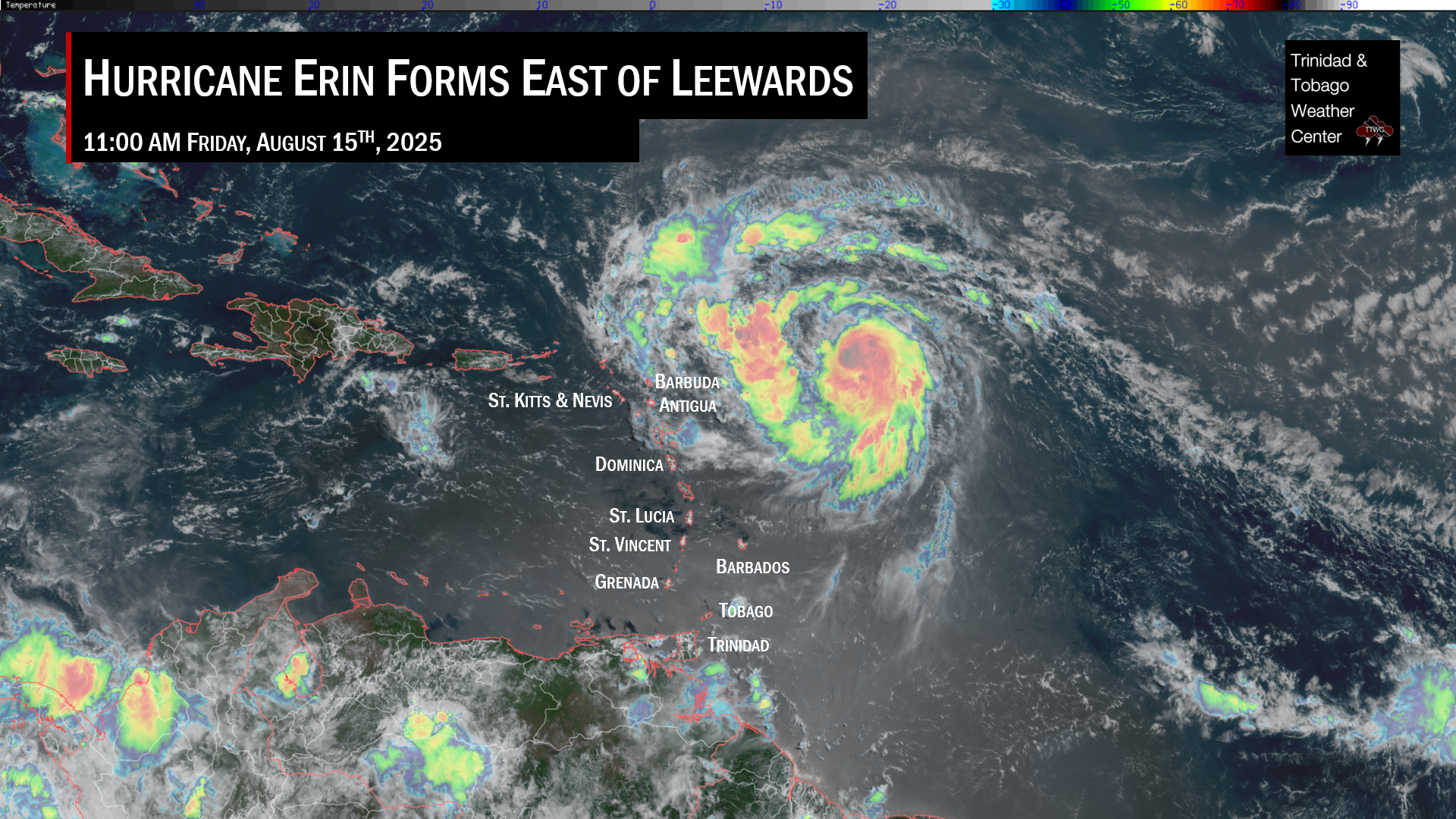
Tropical waves continue to roll off the African Coast, which is expected for May, but none have moved across Trinidad and Tobago, producing measurable rainfall yet. While the atmosphere is shifting into a “Wet Season” pattern, the Wet Season is yet to be officially declared.
With these early-season tropical waves, showers and thunderstorms tend to be quite spare, and the wind shifts associated with them are quite weak. This trend continues in the case of these next two tropical waves for 2023.
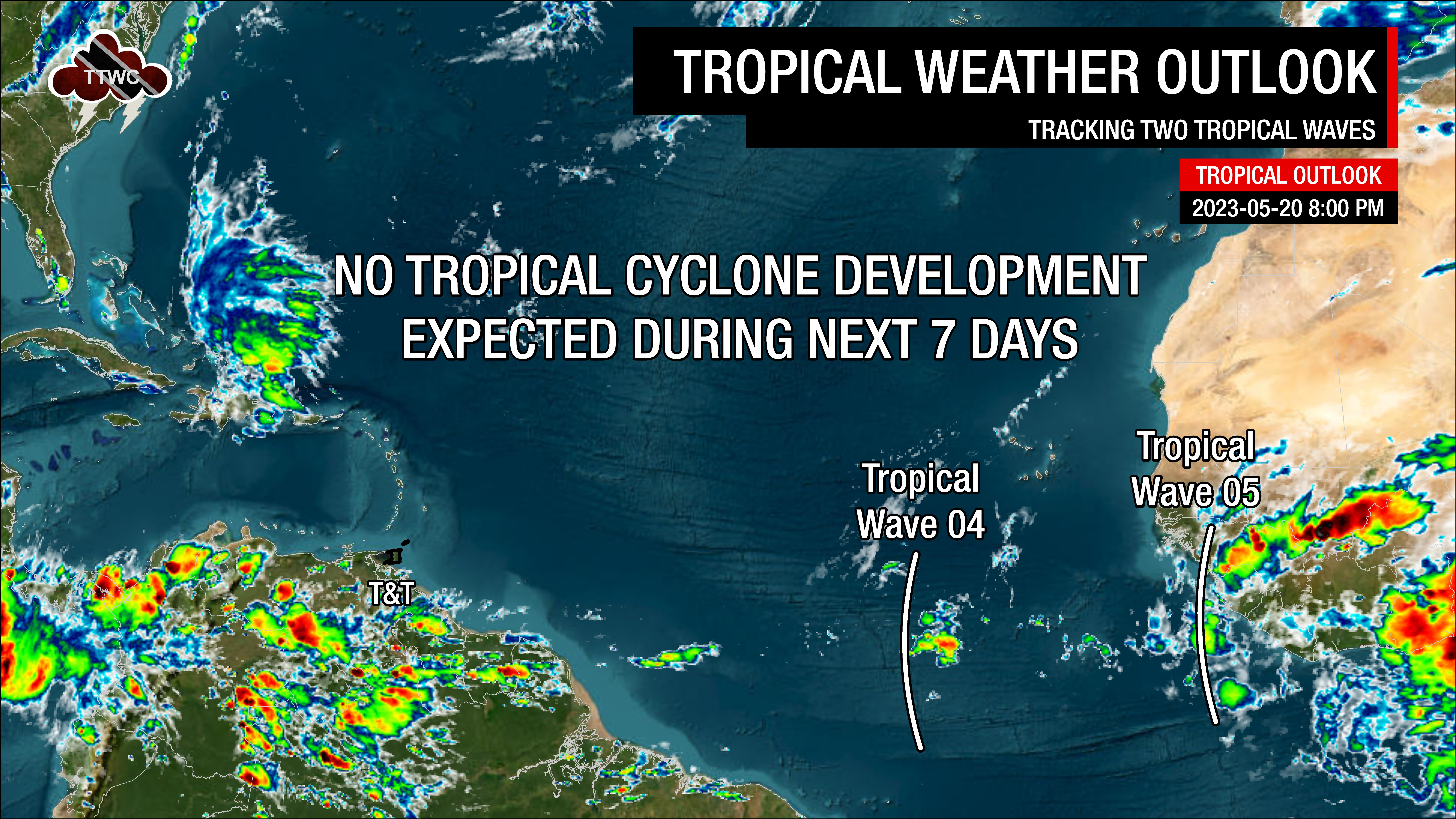
What you need to know
— Tropical Wave 04: This slow-moving wave has been near-stationary for the last several days, with its axis analyzed along 29W and south of 13N, moving west at 10 knots (18 KM/H). Based on the latest model guidance, the wave definition is forecast to dissipate in the central Atlantic Ocean, with its moisture being absorbed by the following tropical wave.
— Tropical Wave 05: The axis of this tropical wave is located along 12W, moving west at 10 knots to 15 knots (18-27 KM/H). Scattered showers have been noted on either side of the wave axis, mainly across the coastal waters of Africa. Similar to TW04, this tropical wave is forecast to lose its signature in the central Atlantic Ocean.
— Hazards: Unrelated to tropical wave and Intertropical Convergence Zone activity, several weather features are forecast to come together from Sunday, May 21st through Tuesday, May 23rd, producing periods of heavy rainfall and gusty winds. Severe weather is possible. See more details in the weather forecast.
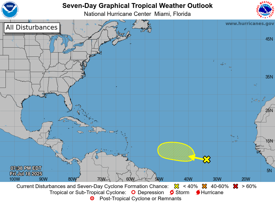
— Development Concerns: Tropical cyclone development is not forecast over the next seven days, according to the National Hurricane Center.
Tropical Wave 04
The fourth tropical wave analyzed as of 8:00 PM May 20th, 2023, is along 29W and south of 13N, moving west at 10 knots (18 KM/H). This particular wave has been moving very slowly across the Atlantic Ocean over the last several days, with numerous occasions where it was stationary south of the Cabo Verde Islands.
Tropical waves’ signature is best seen at the 700-millibar level, approximately three kilometers above ground. A weak vorticity maximum at the 700-millibar level is located along 29/30W as of 8:00 PM, Saturday, May 20th, 2023, indicative of the location of the wave. There are a few scattered showers along the wave axis.
Across the wave axis, TPW values are near 2.13 inches, with relative humidity between 300mb to 850mb, around 68%, indicative of a relatively dry atmosphere. Wind shear is moderate, with speeds up to 20 knots.
In the coming days, as it slowly moves west, forecast models show the tropical wave losing its signature in the central Atlantic Ocean by midweek as the following tropical wave catches up and absorbs the moisture plume. As a result, this tropical wave is not forecast to move across T&T.
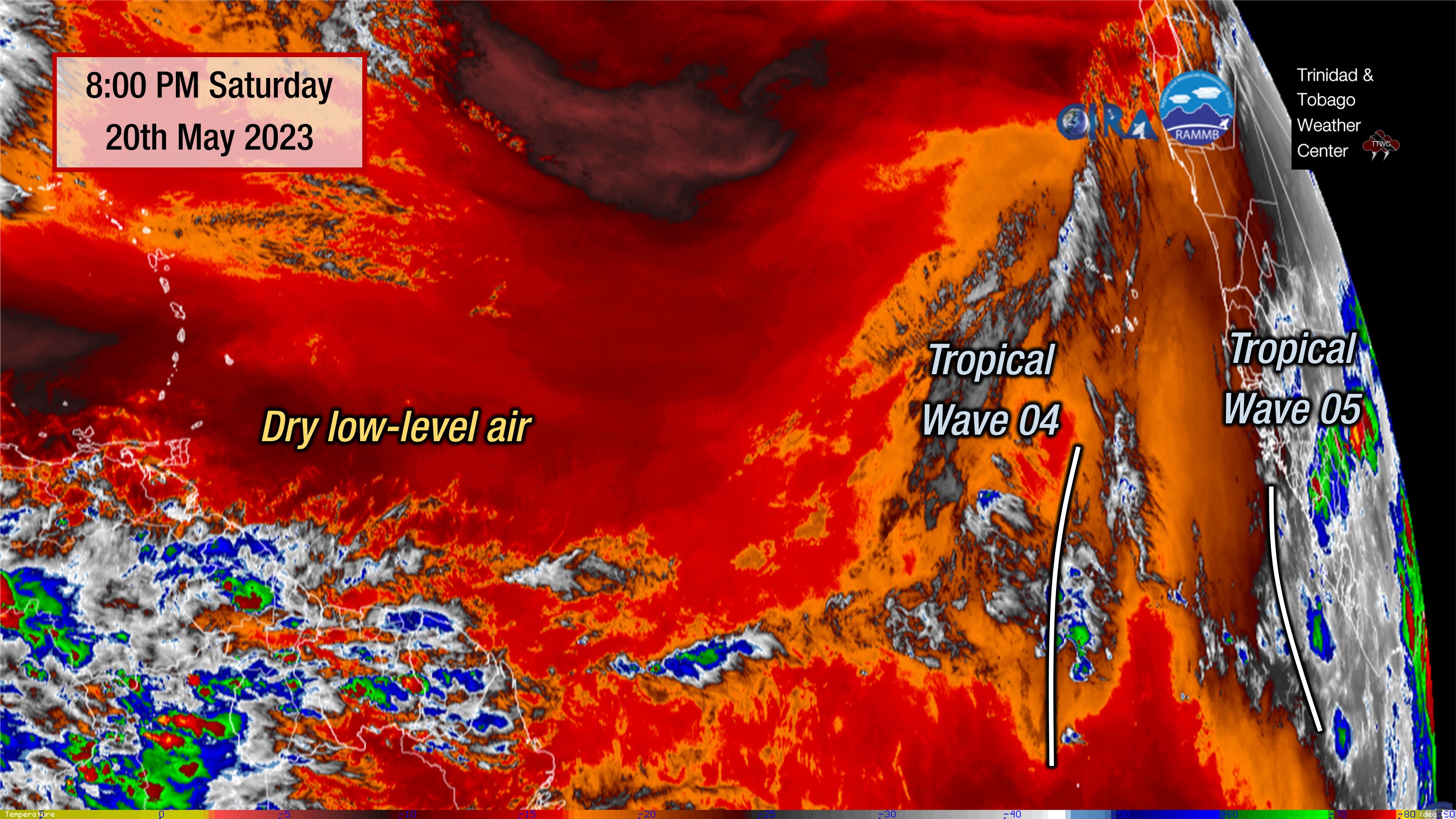
Tropical Wave 05
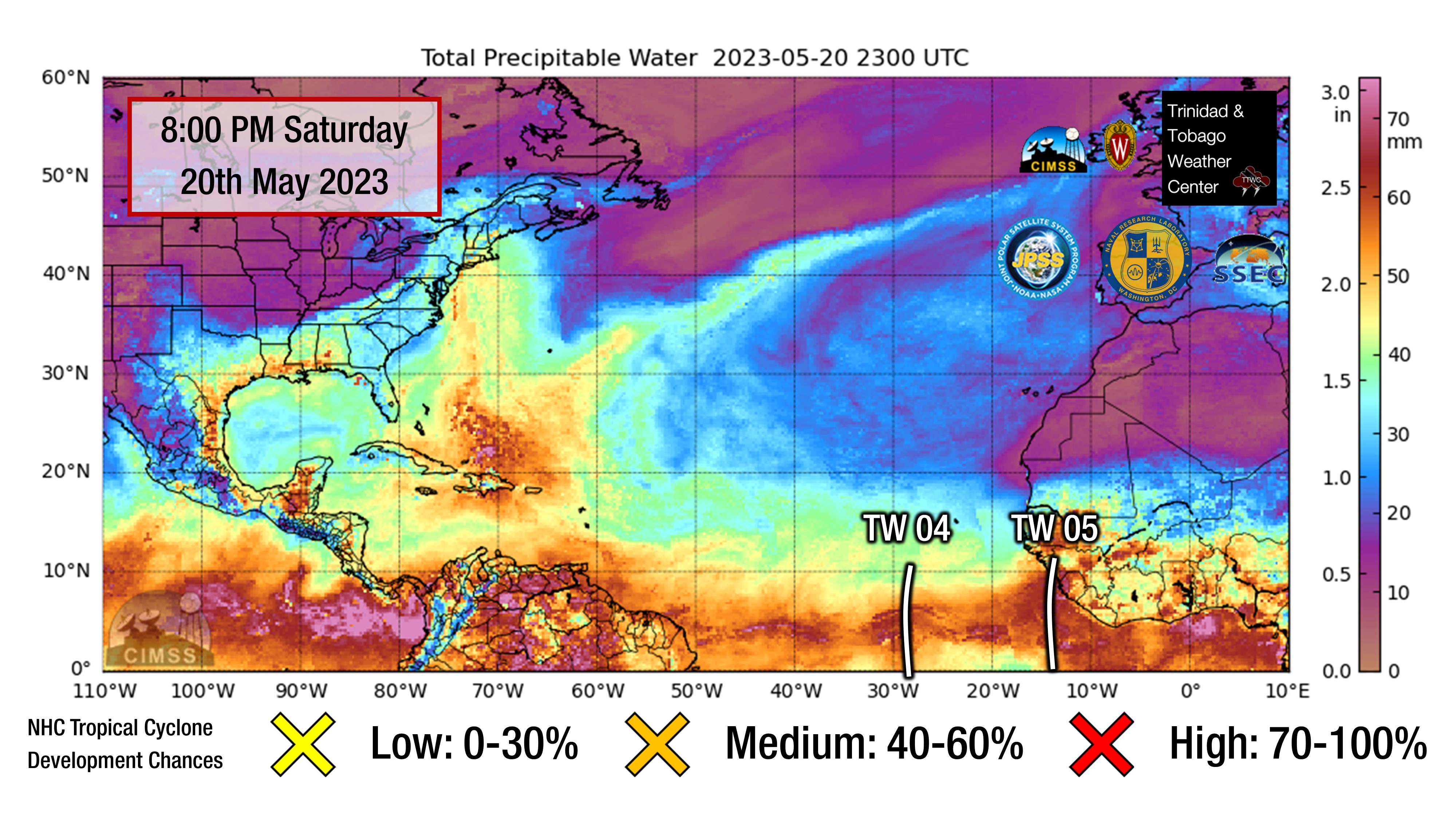
The fifth tropical wave for 2023 is leaving the African coast with pulsing convection, mainly on land western Africa, as it interacts with the Monsoon Trough. As of 8:00 PM, the axis of this tropical wave is located along 12W, moving west at 10 knots to 15 knots (18-27 KM/H).
Based on forecast models, this wave is forecast to catch TW04 in the Central Atlantic by mid-week, with it also losing its wave signature. However, high levels of precipitable water (atmospheric moisture) are forecast to remain across the southern Windwards through next week, with a surge in moisture moving in around between June 1st and June 3rd, which could be associated with the remnants of this wave.
From West Africa, with typical trade winds and steering currents (between 10-20 knots), tropical waves take between five to seven days to make it across the Atlantic to T&T. When trade winds are anomalously light, like they are forecast to be this upcoming week, waves can take longer to traverse the Atlantic Ocean.
Ultimately, if the ITCZ doesn’t move across T&T over the next seven to ten days and produce measurable rainfall, T&T may see its latest start to the Wet Season since the early 2010s.
Not Every Tropical Wave Brings Severe Weather
Tropical waves vary in intensity as it travels westward across the Atlantic. This variability can be on the order of days to as short term as hours. Sometimes, you may see satellite imagery that shows heavy thunderstorms and deep convective activity east of Trinidad and Tobago during the late night and early morning, but by daybreak – nothing.
This is due to diurnal (daily) variations in convective showers whereby convection peaks overnight and wanes during the day for already occurring convective systems (i.e., not triggered by daytime heating).
Activity can be enhanced by its proximity to upper-level troughs and the ITCZ but can also be degraded by hostile upper-level conditions and Saharan Dust.