Trinidad and Tobago has experienced seasonally colder temperatures over the past three days, with temperatures dipping as low as 16°C in some interior parts of the country on Saturday morning. With a reinforcing mass of cool and dry air now arriving across the country, cooler-than-normal nighttime temperatures remain forecast for both islands.
What’s causing the cool temperatures?
Over the last several days, an Atlantic High-Pressure system remained in place across the southern Windwards, including Trinidad and Tobago, channeling cooler and drier air toward the region. This initial air mass inhibited cloud formation at night, with little moisture (or water vapor), allowing for heat to escape from the ground at night.
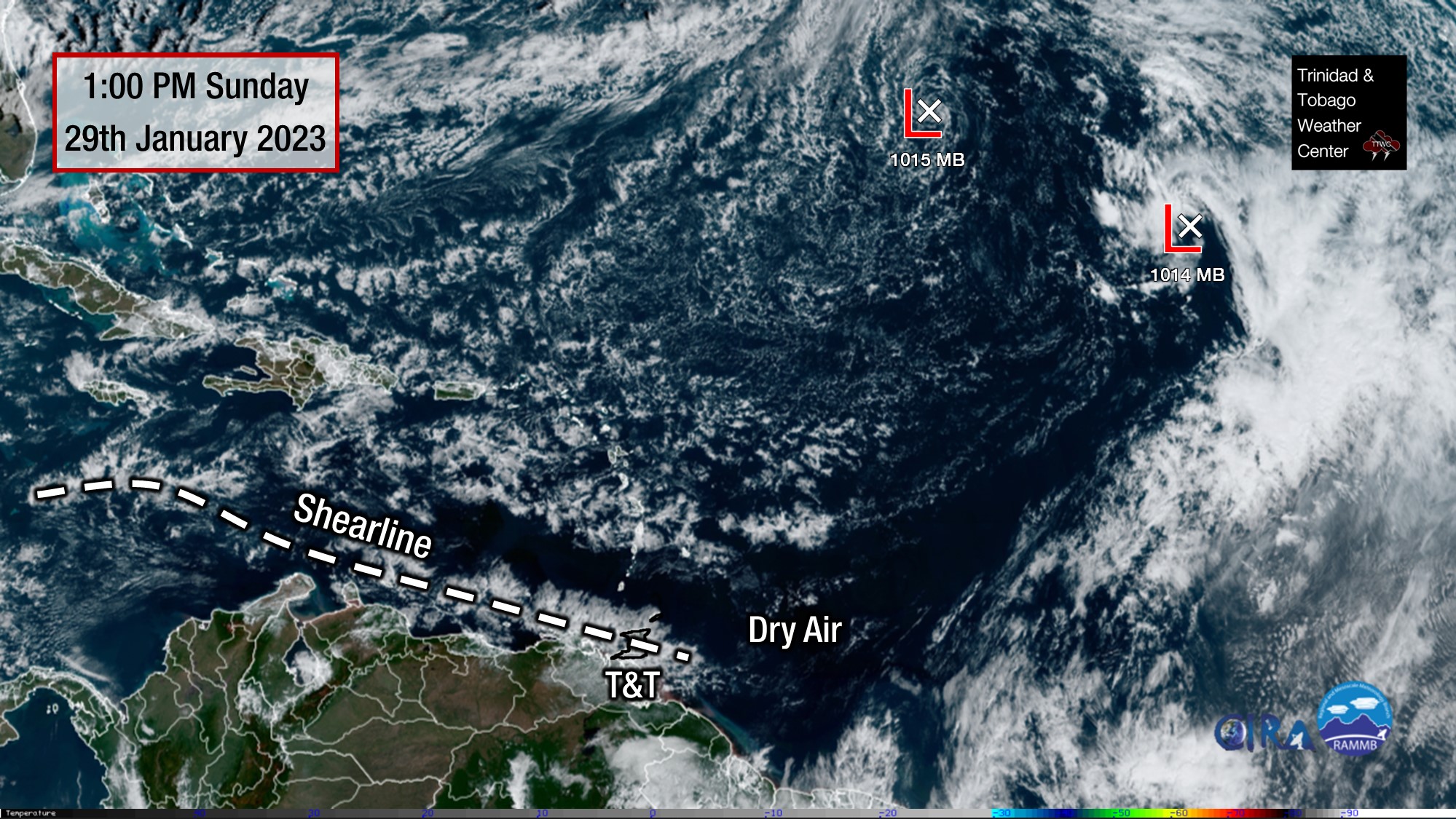
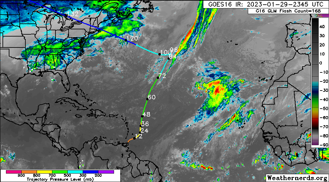
Now, a shearline, which is a decaying or very weakened cold front, made its way across the entirety of the Eastern Caribbean and has moved across Trinidad and Tobago on Sunday, continuing southward. In the wake of this shearline, a dry slot has developed with light winds, lower-than-usual relative humidities, and no cloud cover.
This dry and cool airmass has been traced back to originating over North America and made its way down to the Caribbean due to the atmospheric circulations over the Atlantic – namely a now-weakening low-pressure system northeast of the Lesser Antilles.
While moisture and temperature increased on its journey to T&T, the conditions remained dry and stable enough to hinder clouds’ development. Situations like these are not frequent, but they tend to occur several times during our dry season.
Low temperatures during this time of year are normal, as the Northern Hemisphere experiences winter.
Cool temperatures across Trinidad result from several factors occurring:
- Calm/near-calm winds
- Little to no cloud coverage;
- Winds originating from the northeast to the north at the lower levels of the atmosphere;
- Low amounts of low-level moisture (water vapor/relative humidity).
The dew point is the atmospheric temperature below which water droplets begin to condense, and dew can form. Meteorologists can determine the moisture content of the atmosphere near the surface and estimate the minimum temperature.
A lower dew point means that there is less water vapor in the air. Water vapor can absorb and radiate heat back to the surface. Hence, the lower the water vapor content, the more infrared radiation (i.e., long-wave radiation) can escape from the earth’s surface and cause rapid cooling.
Calm winds and no cloud coverage are due to a persistent sub-tropical high-pressure system that will begin to dominate the weather for much of January, causing dry air at mid and upper levels of the atmosphere and inhibiting cloud formation.
Lack of cloud coverage also leads to fairly warm days when temperatures reach 30-32°C.
For vulnerable persons, who might be especially susceptible to cooler temperatures, such as babies or people suffering from arthritis, it may be best to layer up as a way to keep warm at night.
Forecast Into This Week
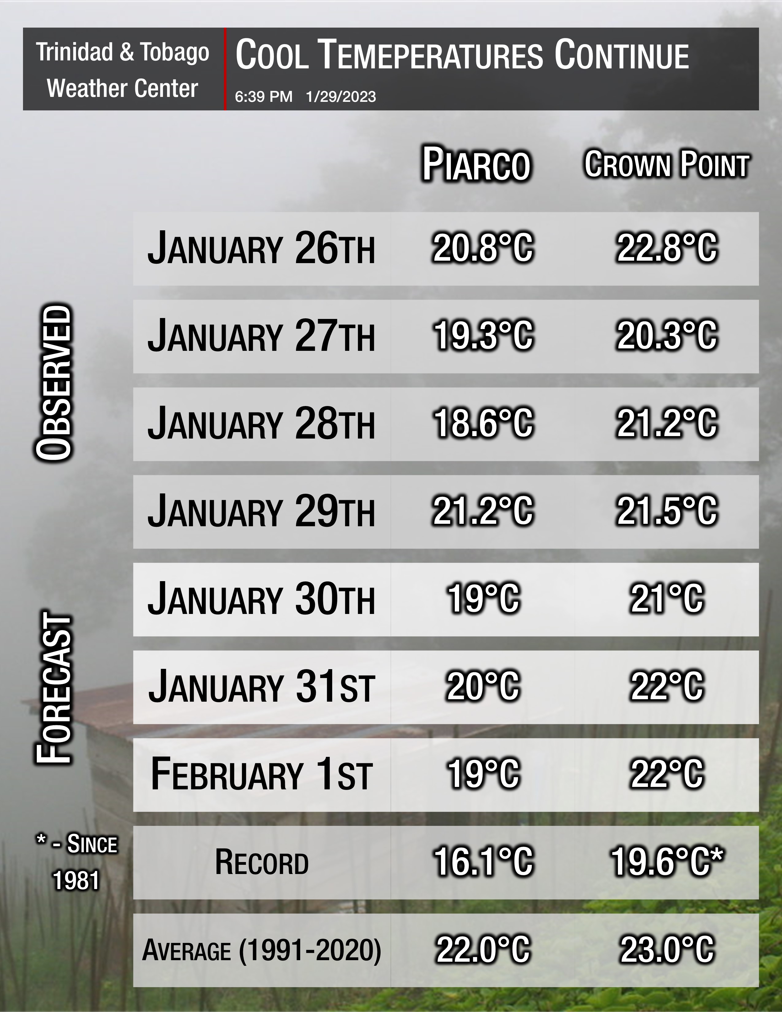
For tonight, generally, dry conditions are expected to persist, with minimal cloud cover expected. This would result in temperatures in the upper teens (18°C to 20°C) across Trinidad and lows near or at 21°C across Tobago. Mostly clear skies are expected overnight Sunday, January 29th, into Monday, January 30th, 2023.
By Wednesday afternoon (February 1st), a low-level trough is forecast to move across the southern Windwards and Trinidad and Tobago, marginally increasing moisture levels and resulting in slightly warmer nighttime temperatures through the end of the week.