


Through Tuesday, mostly sunny starts will give way to variably cloudy conditions and isolated showers and thunderstorms favoring western areas of Trinidad. By midweek, an active Intertropical Convergence Zone is forecast to bring periods of heavy rainfall to both islands.
What you need to know
— Rainfall: Through Tuesday, isolated showers and the odd thunderstorms are forecast, favoring the western half of Trinidad. From Wednesday through the end of the week, a combination of rain, showers, and thunderstorms are forecast across the country. Over the next five days, between 50 and 100 millimeters of rainfall is forecast, with localized areas accumulating up to 150 millimeters.
— Hazards: The main hazards through Tuesday will be localized and short-lived street or flash flooding and possible gusty winds accompanying heavier showers or thunderstorms. From Wednesday through the end of the week, street/flash flooding is very likely in heavier showers and thunderstorms, with wind gusts up to 45 KM/H very likely and gusts up to or over 55 KM/H possible in heavy showers or thunderstorms. Lightning will accompany thunderstorms. Landslides are possible across elevated areas of Trinidad and across Tobago from Wednesday. Riverine flooding, particularly near smaller watercourses across southern and eastern areas, is possible from Thursday.
— Alerts/Watches/Warnings: There are no alerts, watches, or warnings in effect for Trinidad and Tobago from the Trinidad and Tobago Meteorological Service. There are no tropical storm or hurricane watches or warnings in effect for T&T at this time.
The Forecast
Monday
MondayTuesday
TuesdayWednesday
WednesdayThursday
ThursdayFriday
FridayMarine: Through Friday, moderate seas are forecast in open waters with waves up to 2.0 meters. In sheltered areas, waves are forecast to be below 1.0 meter with long-period swells through Tuesday, causing larger, battering waves along northern and eastern coastlines. Through the remainder of the week, spring tides are also forecast. Sheltered areas may occasionally become choppy during showers and thunderstorms.
Temperatures
Through Tuesday, maximum high temperatures are forecast to remain fairly warm, with cooler temperatures through the remainder of the week due to increased rainfall and cloud cover.
Monday
Low: 23-24°C
High: 32-33.5°C
A maximum high of 32.0°C is forecast across Tobago, while temperatures are forecast to reach 33.5°C in Trinidad, with hotter temperatures across urbanized areas. Heat indices (or feels-like temperatures) are forecast to be between 32°C and 45°C. Locally higher heat indices are possible in urbanized areas like Port of Spain, Chaguanas, and San Fernando.
Tuesday
Low: 24-25°C
High: 31-33°C
A maximum high of 31.0°C is forecast across Tobago, while temperatures are forecast to reach 33.0°C in Trinidad, with hotter temperatures across urbanized areas. Heat indices (or feels-like temperatures) are forecast to be between 32°C and 42°C. Locally higher heat indices are possible in urbanized areas like Port of Spain, Chaguanas, and San Fernando.
Wednesday-Friday
Low: 23-24°C
High: 29°C
With increased cloud cover and rainfall, maximum high temperatures are forecast to struggle to reach 30.0°C over these three days. Heat indices are forecast to remain below 31.0°C, which still requires some caution in prolonged activity.
Forecast Impacts
Flooding
FloodingThrough Tuesday, street/flash flooding is possible in heavier showers or thunderstorms across northern/western Trinidad and Tobago. By Wednesday through the end of the week, street/flash flooding is very likely across both islands, Riverine flooding chances are forecast to increase by Thursday. However, overall rainfall totals have trended downwards over the last 48 hours, keeping riverine flooding chances at low to medium by the weekend. Smaller watercourses may reach threshold levels by Friday, particularly across eastern and southern areas of Trinidad.
Forecast Rainfall Totals
- Monday: Less than 5 millimeters of rainfall across both islands, with isolated totals of up to 15 millimeters across parts of western and northeastern Trinidad as well as Tobago.
- Tuesday: Less than 10 millimeters of rainfall across both islands, with isolated rainfall totals of up to 25 millimeters across Tobago and northwestern Trinidad.
- Wednesday: Up to 25 millimeters of rainfall across both islands. Rainfall totals of up to 50 millimeters are forecast across the eastern half of both islands, as well as in isolated areas across western coastal Trinidad.
- Thursday: Between 20 and 50 millimeters of rainfall across both islands. Higher totals are forecast to trend across the eastern and southern halves of Trinidad and along the western coastal areas of Trinidad.
- Friday: Between 15 and 25 millimeters of rainfall across both islands, totaling up to 50 millimeters across Tobago and northeastern Trinidad.
Putting the rainfall forecast into context, rainfall rates in excess of 50 millimeters per hour or areas that receive in excess of 25 millimeters within an hour tend to trigger street flooding across the country or flash flooding in northern Trinidad. For riverine flooding to occur, a large area of the country (not just in highly localized areas of western coastal Trinidad) would have to record upwards of 75 millimeters within 24 hours, and rainfall would have to fall across major rivers’ catchment areas.
Strong Thunderstorms
Strong ThunderstormsStrong thunderstorms can produce frequent lightning, gusty winds, and violent rainfall rates. Short-lived funnel cloud development is possible throughout the week, particularly on Monday and Tuesday due to light and variable low-level winds. If a funnel cloud touches down on a body of water, it becomes a waterspout; if it touches down on land, it becomes a tornado.
Gusty Winds
Gusty WindsPossible impacts include localized wind damage to trees, power lines, and small structures. Light outdoor objects may topple or become airborne such as garbage cans, potted plants, loose galvanize or construction material, and other outdoor furniture. Tents may jump. Older/weaker trees may fall, bringing down utility poles and lines.
Other Hazards
With forecast rainfall accumulations, landslides are likely across Tobago from Wednesday through Friday.
Why I May Not/Will Not See Rainfall?
A frequent complaint is the forecast is wrong because I didn’t experience any rainfall. Scattered showers mean that you, individually, may experience some showers intermittently throughout the day, and there is a higher chance for this activity than isolated activity. Widespread showers mean that nearly all persons and areas may experience rainfall.
Through Tuesday, isolated rainfall is forecast. From Wednesday, scattered to widespread rainfall is forecast.

Forecast Discussion

Tropical Waves (and other notable weather features) near and east of T&T: Based on the Tropical Analysis and Forecast Branch’s 18Z surface analysis on October 23rd, 2022, as well as the latest satellite and model guidance:
- The 46th tropical wave for 2022 (TW46) moved across Trinidad, Tobago, and the Lesser Antilles today (Sunday, October 23rd, 2022) but lost its signature and was dropped from the analysis.
- The 47th tropical wave for 2022 (TW47) is along 50°W, south of 18°N, moving west at 5 to 10 knots (9 – 18 KM/H). This wave is interacting with an upper-level trough, currently on its divergent side, leading to scattered showers trailing the wave axis. This tropical wave is forecast to move across the region by Tuesday night, with a surge of low-level winds and the Intertropical Convergence Zone trailing.
- Invest 94L is a tropical disturbance in the subtropical Atlantic with low chances of tropical cyclone formation over the next five days according to the National Hurricane Center. This system, regardless of formation, is not forecast to affect Trinidad, Tobago, or the Lesser Antilles.
Through Tuesday, a weak surface to low-level ridge is forecast to remain in place. Trinidad and Tobago is on the periphery of this ridge, with surface to low-level convergence under a favorable mid- to upper-level environment. Weak low-level winds are forecast to remain in place through Tuesday, leading to warm temperatures. Daytime heating, sea breeze convergence, and orographic effects are forecast to trigger/enhance showers or the odd thunderstorm across the western and hilly areas of both islands.
Tropical Wave 47 is forecast to move across the region by late Tuesday, ushering in a period of unsettled weather for Trinidad and Tobago into the end of the week. Convergence associated with a surge of low-level winds is forecast to trail this tropical wave, leading to breezy conditions across the country, gusty winds with rainfall, and increased showers and isolated thunderstorms. In addition, the Intertropical Convergence Zone is forecast to trail TW47 from Tuesday night and remain across Trinidad and Tobago through the end of the week. By Thursday through Saturday, a series of troughs (surface to mid-level) are forecast to move across Trinidad, Tobago, and the southern Windwards, generating additional showers, thunderstorms, and periods of rain as they interact with the ITCZ.
Through Tuesday, wind shear is forecast to remain moderate from the west but fall off by night and remain at light to moderate levels throughout the forecast period, between 0 and 20 knots. Moisture levels are forecast to be moderate through Tuesday with relative humidity up to 60%. Then, they become very moist through the remainder of the week, with relative humidities up to 90% at times. With light shear, high moisture, a favorable upper-level pattern, and favorable low-level convergence, persisting heavy showers and thunderstorms are possible during the latter half of the week.
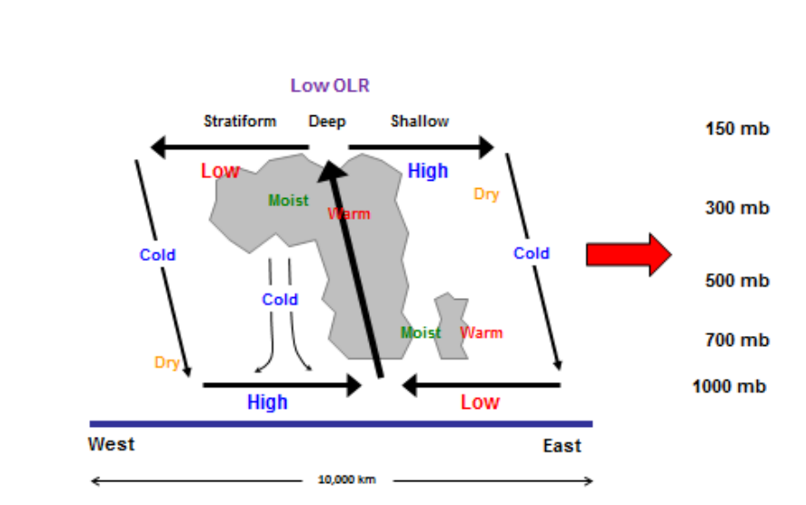
Overarching this week will be a series of larger-scale features supporting shower and thunderstorm development. The convectively active phase of a Convectively-Coupled Kelvin Wave (CCKW) is forecast to remain across the region through the end of the month. CCKWs are huge impulses spanning thousands of miles moving west to east through the stratosphere, typically rolling along at about 30 to 40 mph. Like a giant chimney, each CCKW has a broad zone of rising air at its heart, tilted toward the west as you move up. As low-level air converges, the resulting circulation favors the development of showers and thunderstorms ahead of the CCKW.
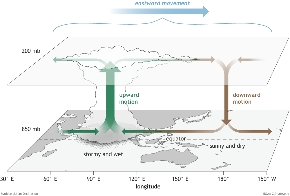
Another factor aiding shower and thunderstorm development will be the convectively active phase of the Madden-Julian Oscillation (MJO). Like the CCKW, the MJO is a large-scale rising air area promoting shower and thunderstorm development. This convectively active phase of the MJO is also forecast to remain across T&T and the Caribbean region through the end of the month, promoting rainfall activity.
Ultimately, Trinidad and Tobago is forecast to experience a cloudy second half of the week with periods of rain, showers, and thunderstorms over a broad area. The country may be placed under an Adverse Weather Alert by Tuesday night. By Thursday through Friday, a Localized Flood Alert or Riverine Flood Alert may not be out of the question, depending on where higher rainfall accumulations occur and how much rainfall falls in the 72 hours. Note: Only the Trinidad and Tobago Meteorological Service can issue these alerts for Trinidad and Tobago.


