


Several features are forecast to bring a mixed bag of weather conditions to Trinidad and Tobago over the next five days – from sunny skies to hazy and cloudy conditions to showers and thunderstorms. What is not expected to impact Trinidad and Tobago over the next five days – a tropical storm.
What you need to know
— Saharan Dust: Dust levels are declining across Trinidad and Tobago over the next few days, with mild to moderate concentrations lingering through Friday. A high-concentration surge of dust is set to return by Saturday, July 16th, 2022, across T&T.
— Rainfall: Scattered showers and thunderstorms are forecast mainly from late Thursday through Friday, with less impactful rainfall forecast through the weekend. Generally, up to 50 millimeters are possible across both islands, with isolated higher totals favoring eastern areas.
— Hazards: The main hazards, mainly on Friday when most of the impactful weather is forecast for T&T, are gusty winds up to and in excess of 45 KM/H accompanying heavy showers or thunderstorms, as well as localized street/flash flooding favoring eastern and southern Trinidad, as well as Tobago. The chances for riverine flooding remain low at this time. Lightning will accompany thunderstorms.
— Alerts/Watches/Warnings: There are no alerts, watches, or warnings in effect for T&T from the Trinidad and Tobago Meteorological Service at this time. There are also no tropical storm or hurricane watches or warnings in effect for T&T.
The Forecast
Wednesday
WednesdayThursday
ThursdayFriday
FridaySaturday
SaturdaySunday
SundayMarine: Through Monday, seas are forecast to be moderate, with waves in open waters up to 2.0 meters. In sheltered areas, waves are forecast to be near or below 1.0 meter.
Temperatures
Through the forecast period, the minimum low in Trinidad and Tobago is forecast to be between 24.0°C and 26.0°C.
On Wednesday and Thursday, maximum highs across the country are forecast to be generally up to 32.0°C in Trinidad and Tobago. In urbanized areas like Port of Spain, Scarborough, San Fernando, and Chaguanas, the maximum high temperatures could exceed 34.0°C.
By Friday, maximum highs across the country are forecast to be below 30.0°C in Trinidad and Tobago due to increased cloud cover. In urbanized areas like Port of Spain, Scarborough, San Fernando, and Chaguanas, the maximum high temperatures could exceed 30.0°C.
During the weekend, with light winds and variably cloudy skies, maximum highs across the country are forecast to be generally up to 31.0°C in Trinidad and Tobago. In urbanized areas like Port of Spain, Scarborough, San Fernando, and Chaguanas, the maximum high temperatures could exceed 33.0°C.
Forecast Impacts
Flooding
FloodingThere is a medium to high chance of street and flash flooding, mainly on Friday and across southern, and eastern Trinidad. Chances for riverine flooding remain low as major rivers across the country are well within their banks.
Forecast Rainfall Totals
- Wednesday: Little to no rainfall across Trinidad and Tobago. Up to 5 millimeters are possible in highly isolated showers, favoring eastern areas.
- Thursday: Less than 5 millimeters across the country, with isolated totals up to 10 millimeters across eastern and southern areas of Trinidad.
- Friday: Between 15 and 25 millimeters of rainfall across the country. Across northern, eastern and southern coastal areas, as well as across Tobago, rainfall totals up to 45 millimeters are forecast. In these areas, highly isolated rainfall totals exceeding 45 millimeters are possible.
- Saturday: Between 5 and 15 millimeters across the country, with rainfall totals trending higher across western coastal Trinidad, central and northern areas of Trinidad, as well as across Tobago. Isolated rainfall totals, particularly along western and hilly areas, could exceed 25 millimeters.
- Sunday: Between 5 and 15 millimeters across the country, with rainfall totals trending higher across central and northern areas of Trinidad, as well as across Tobago.
Putting the rainfall forecast into context, rainfall rates in excess of 50 millimeters per hour or areas that receive in excess of 25 millimeters within an hour tend to trigger street flooding across the country or flash flooding in northern Trinidad. For riverine flooding to occur, a large area of the country (not just in highly localized areas of western coastal Trinidad) would have to record upwards of 75 millimeters within 24 hours, and rainfall would have to fall across major rivers’ catchment areas.
Strong Thunderstorms
Strong ThunderstormsMainly on Friday into Saturday, funnel cloud development is possible to due to near calm to light and variable winds. The highest chances for funnel cloud/waterspout development exists along western coastal areas of both Trinidad and Tobago, as well as along southern and eastern coastal areas of Trinidad. If a funnel cloud touches down on a body of water, it becomes a waterspout; if it touches down on land, it becomes a tornado.
While abundant frequent cloud-to-ground lightning isn’t likely, lightning is expected in thunderstorm activity.
Gusty Winds
Gusty WindsWith wind gusts up to and in excess of 45 KM/H, whole trees are expected to be in motion, and there may be some inconvenience when walking against the wind gusts. Light outdoor objects may topple or become airborne such as garbage cans, potted plants, loose galvanize or construction material, and other outdoor furniture. Tents may jump. Older/weaker trees may fall, bringing down utility poles and lines.
Other Hazards
Saharan Dust will remain across the region through the forecast period, with an increase from Saturday, reducing air quality and affecting visibility.
Why I May Not/Will Not See Rainfall?
A frequent complaint is the forecast is wrong because I didn’t experience any rainfall. Scattered showers mean that you, individually, may experience some showers intermittently throughout the day, and there is a higher chance for this activity than isolated activity. Widespread showers mean that nearly all persons and areas may experience rainfall.
Isolated to scattered rainfall is forecast on Friday, with isolated rainfall on Saturday and Sunday.

Forecast Discussion
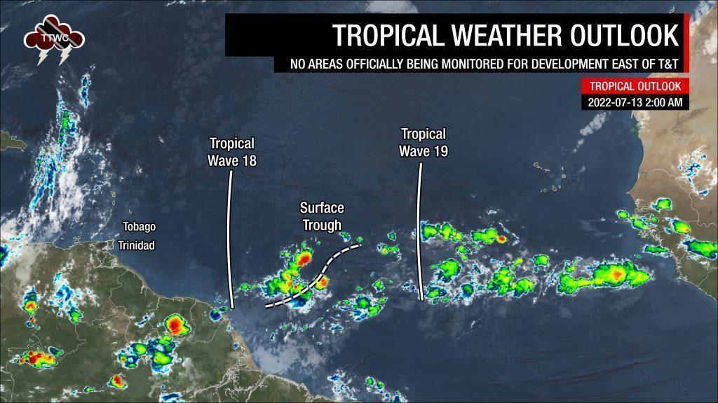
Tropical Waves East of T&T: Based on the Tropical Analysis and Forecast Branch’s 06Z surface analysis on July 13th, 2022, as well as the latest satellite and model guidance:
- The 18th tropical wave for 2022 (TW18) is along 55°W, south of 20°N, moving west at 15 knots (28 KM/H). No deep convection has been noted along this wave axis. TW18 is forecast to move across T&T this (Wednesday) evening, ahead of a leading surge of Saharan Dust.
- A surface trough embedded with the Intertropical Convergence Zone (ITCZ) is located between 11°N, 40°W and 5°N, 47°W. This trough has isolated moderate to strong convection on either side of the trough axis, associated with the ITCZ. This trough and the ITCZ are forecast to affect Trinidad and Tobago on Friday.
- The 19th tropical wave for 2022 (TW19) is along 36°W, south of 20°N, moving west at 15 knots (27 KM/H). This wave is forecast to move across Trinidad and Tobago on Friday into Saturday, July 15th to 16th, 2022. There are some weak showers where the wave meets the ITCZ, while dense Saharan Dust limits convection elsewhere.
This is a contentious forecast, primarily due to what different meteorological offices across the Eastern Caribbean determined what is forecast to affect the region over the next five days and the conflicting timing of impactful weather based on leading model guidance.
The analyses of the tropical waves, surface trough, and ITCZ align with most meteorological offices across the Eastern Carribean. Our above forecast and below discussion are based on a blend of model guidance and the latest satellite and diagnostic tools available as of 06Z Wednesday, July 16th, 2022.
On Wednesday, a deep-layered high-pressure system is forecast to remain present across Trinidad, Tobago, and the Lesser Antilles leading to mostly stable weather. The persistent upper-level low system, anchored over the Greater Antilles for the first half of this week, is set to move westward, away from our area today. This movement will reduce upper-level clouds from our area, leading to mostly sunny skies and a drier upper-level environment.
By Wednesday evening, a weak Tropical Wave 18, nearly devoid of convection, is forecast to move across the Lesser Antilles. It is located on a leading edge of a Saharan Dust surge, with higher concentrations set to impact the Leewards and Windwards, excluding Trinidad and Tobago.
On Thursday, low-level cloud patches are forecast to bring a few brief passing showers, interrupting mostly sunny skies across Trinidad and Tobago while mostly sunny and hazy skies elsewhere.
By Thursday night, the surface trough (an area of lower than usual pressure at low levels of the atmosphere) and the ITCZ are forecast to approach Trinidad and Tobago. Both features are forecast to bring increased moisture and instability, fuelling scattered showers and thunderstorms through Friday. Activity with the ITCZ has its strongest activity occurring between 12:00 AM and 6:00 AM local time, with another peak during the Northern Hemisphere summer months between 12:00 PM to 3:00 PM. In tandem, T&T will be placed on the favorable side of a developing upper-level trough, extended southwest across the eastern Caribbean Sea. With a low-shear and favorable upper-level environment, showers and thunderstorms may be locally enhanced on Friday.
Tropical Wave 19 is forecast to move across the Lesser Antilles by Friday night into Saturday. Forecast models indicate that Trinidad and Tobago will remain across the southern portion of the wave axis, with near calm/variable to light southerly to southeasterly winds on Saturday. Nearly all of the active weather associated with this forecasted strong tropical wave is modeled to remain well north of Trinidad and Tobago on Friday night into Saturday.
While our Lesser Antilles neighbors, north of Barbados and St. Vincent, are forecast to experience the strongest winds and heavier rainfall, this tropical wave will also maintain elevated moisture and instability across T&T, leading to isolated showers and thunderstorms persisting on both Saturday and Sunday.
However, a high-concentration surge of Saharan Dust is set to begin affecting Trinidad and Tobago from mid-Saturday. Though models show that isolated to scattered showers and thunderstorms, Saharan Dust and its drying out of the low to mid-levels are habitually understated in weather prediction models, leading to an erroneous abundance of rainfall activity. Still, ample instability and moisture will be present as the ITCZ will remain near/across T&T, leading to a medium chance of heavy showers/thunderstorms on Saturday, with a low chance of heavy showers/thunderstorms on Sunday.
Uncertainty increases into next week, as the ITCZ and surges of Saharan Dust are both forecast to be present across T&T. At least for now, the prevailing likelihood seems to be a relatively cloudy and wet week on the horizon, particularly from Tuesday, for those planning ahead.


