Though it is still not yet a fully formed tropical cyclone, Potential Tropical Cyclone Two is forecast to bring tropical-storm-force conditions to Trinidad over the next several hours. Any preparations to safeguard life and property should be rushed to completion.
What you need to know
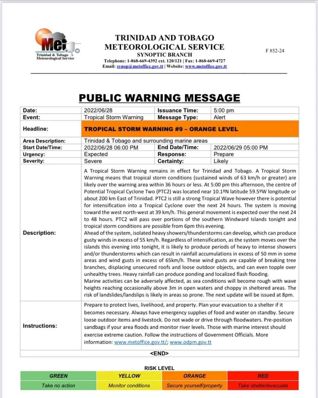
— Alerts/Watches/Warnings: A Tropical Storm Warning (Orange Level) has been issued for Trinidad and Tobago, with peak inclement weather forecast from 6:00 PM Tuesday, June 28th, 2022 through 5:00 AM Wednesday, June 29th, 2022
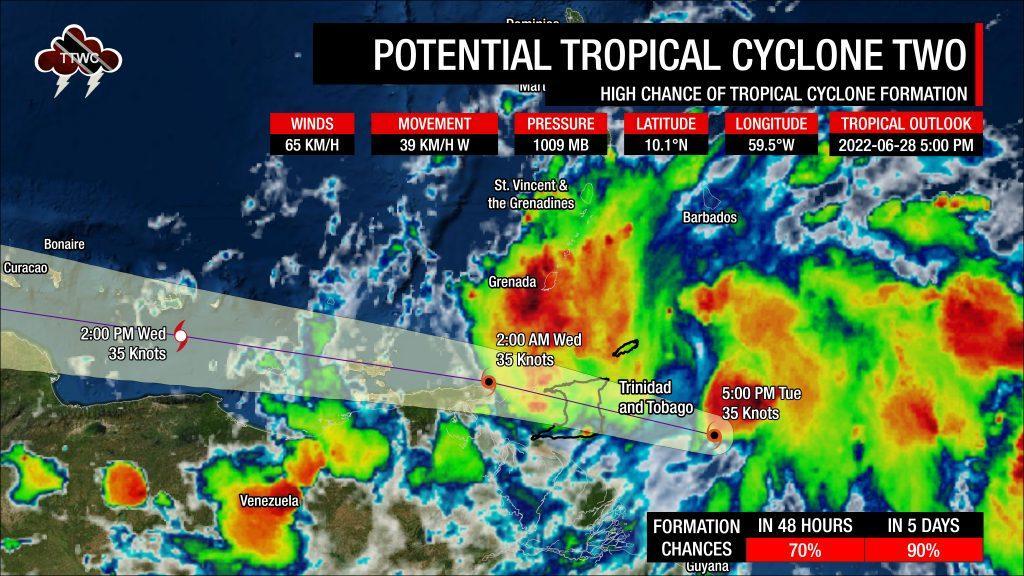
— Track: The latest track from the National Hurricane Center brings the center of this system directly across the island, from central to northwestern Trinidad. Given this system is lopsided and disorganized, impacts will not be concentrated near the center.
— Rainfall: The main hazard associated with this system is flooding rainfall. Through Wednesday, periods of rain, heavy to violent showers, and scattered thunderstorms are forecast Peak intense rainfall and thunderstorms are forecast from after 6:00 PM Tuesday through early Wednesday, with lingering showers, rain, and thunderstorms through early Thursday. Between 25 millimeters and 75 millimeters of rainfall is forecast through Thursday, with higher rainfall totals up to 150 millimeters across eastern and northern Trinidad, Tobago, as well as localized areas of southern Trinidad. Street/flash flooding is very likely, with riverine flooding.
— Wind: The strongest winds associated with this system now are set to move directly across Trinidad. Earlier, the strongest winds initially associated with the system moved north of the country. Trinidad and Tobago is forecast to experience sustained winds up to 65 KM/H are possible with gusts to 85 KM/H. Strong wind gusts near the 85 KM/H-range are forecast to favor eastern coastal Trinidad elevated areas of the Northern Range.
— Seas: Hazardous seas are forecast for exposed, northern and eastern coastlines of Trinidad and Tobago with waves in open waters on Tuesday into Wednesday between 3.0 meters and 3.5 meters. Hazardous seas are also forecast within the Gulf of Paria due to shifting prevailing winds as the system moves across T&T.
The Forecast
Tuesday Night
Tuesday NightWednesday
WednesdayThursday
ThursdayMarine: From mid-Tuesday, open waters particularly east of T&T will be rough, with waves up to 3.5 meters, particularly north and east of Tobago and east of Trinidad. For the remainder of T&T’s open waters, seas will be rough, with waves between 2.5 and 3.0 meters. In sheltered areas, seas will be up to 1.5 meters. For the southwestern Gulf of Paria, seas will be particularly agitated on Tuesday night with waves up to 2.0 meters, while on Wednesday morning, hazardous seas shift to the northwestern Gulf of Paria.
Temperatures
Through the forecast period, the minimum low in Trinidad and Tobago is forecast to be between 24.0°C and 26.0°C.
Maximum highs across the country are forecast to be generally up to 30.0°C in Trinidad and Tobago. In urbanized areas like Port of Spain, Scarborough, San Fernando, and Chaguanas, the maximum high temperatures could exceed 30.0°C.
Through Thursday, temperatures are forecast to be cooler due to increased cloud cover and anticipated rainfall.
Forecast Impacts
Flooding
FloodingThere is a high to a very high chance of street and flash flooding. While initial chances for riverine flooding remain low, by late Wednesday, these chances are forecast to increase across all river basins in Trinidad substantially.
Forecast Rainfall Totals
- Remainder of Tuesday: Between 15 and 25 millimeters across the country, trending higher across northern and eastern areas of Trinidad and across Tobago with totals up to and in excess of 50 millimeters. In highly isolated areas, upwards of 75 millimeters are possible, favoring eastern Trinidad and Tobago.
- Wednesday: Between 15 and 25 millimeters across the country, trending higher across northern and eastern Trinidad with totals up to 50 millimeters.
- Thursday: Between 10 and 25 millimeters across the country, trending higher across southwestern and eastern areas of Trinidad.
Putting the rainfall forecast into context, rainfall rates in excess of 50 millimeters per hour or areas that receive in excess of 25 millimeters within an hour tend to trigger street flooding across the country or flash flooding in northern Trinidad. For riverine flooding to occur, a large area of the country (not just in highly localized areas of western coastal Trinidad) would have to record upwards of 75 millimeters within 24 hours, and rainfall would have to fall across major rivers’ catchment areas.
Strong Thunderstorms
Strong ThunderstormsGusty Winds
Gusty WindsWith winds up to 65 KM/H gusts up to and in excess of 85 KM/H, whole trees are expected to be in motion, and there may be some inconvenience when walking against the wind gusts. Light outdoor objects may topple or become airborne such as garbage cans, potted plants, loose galvanize or construction material, and other outdoor furniture. Tents may jump. Older/weaker trees may fall, bringing down utility poles and lines. Structures may be damaged, particularly those with unsecured roofs.
The Latest Tropical Storm Warning For T&T