


Invest 94L’s chances for tropical cyclone formation have risen on Sunday night, with the National Hurricane Center stating tropical storm watches and warnings may be required for parts of the Windwards and northeastern Venezuela on Monday.
The center of this disturbance is over 1,750 kilometers east-southeast of Trinidad and Tobago as of 8:00 PM Sunday, June 26th, 2022. Model guidance has remained consistent on when and where this disturbance – or eventual tropical cyclone – will traverse.
What we know
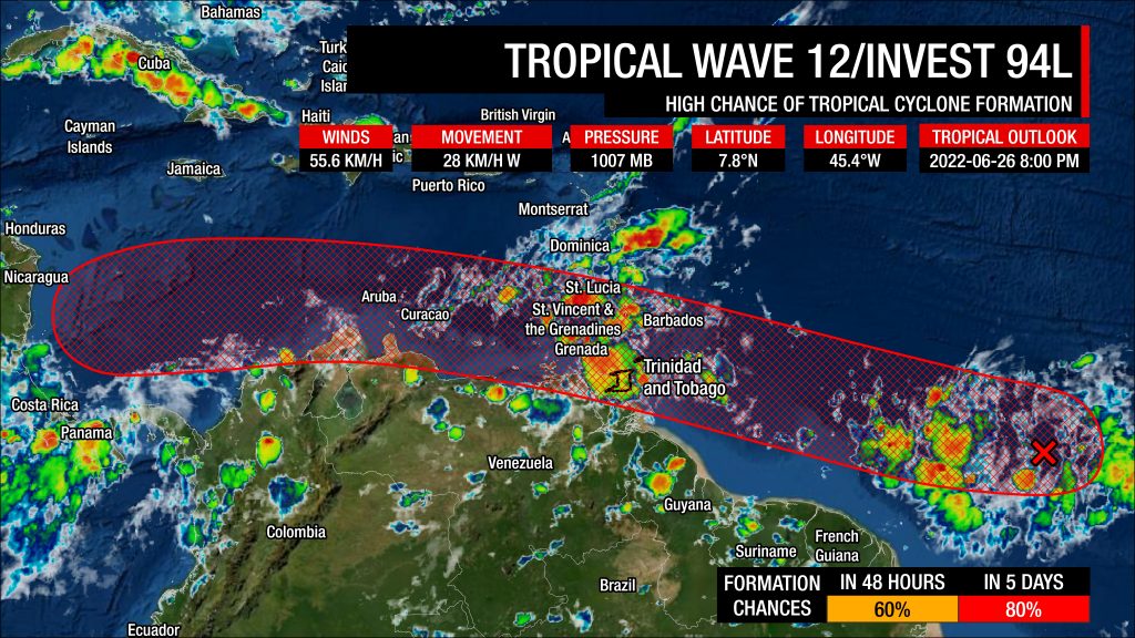
In their 8:00 PM Tropical Weather Outlook, the National Hurricane Center (NHC) has given Tropical Wave 12 (Invest 94L) a medium chance of tropical cyclone formation over the next 48 hours and a high chance over the next five days, at 60 percent and 80 percent respectively.
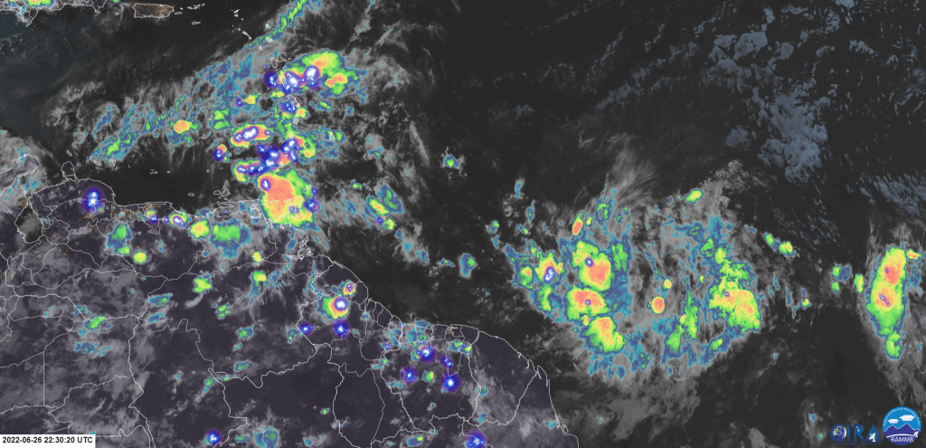
Shower and thunderstorm activity has changed little today, with strong thunderstorms east of the low-level center near 7.8°N, 45.4°W. The wave is located in a high-moisture, low to medium-shear environment with warm sea-surface temperatures near 28°C, favorable upper-level divergence, and low-level convergence – all ingredients supportive of showers, thunderstorms, and tropical cyclone formation. Today, Invest 94L suffered from a marginal increase in wind shear and dry air from the northeast.
Still, the National Hurricane Center says a tropical depression will likely form over the next few days before reaching the Windward Islands Tuesday night. The system is moving to the west/west-southwest at 15 to 20 MPH (24-32 KM/H) over the central Tropical Atlantic.
The NHC added, “Interests in the Windward Islands and along the northeastern coast of Venezuela should monitor the progress of this system, and tropical storm watches or warnings could be required for portions of these areas on Monday. Regardless of development, locally heavy rainfall is possible over the Windward Islands and the northeastern coast of Venezuela Tuesday night and Wednesday.”
Will I be under a tropical storm watch or warning?
A tropical storm warning is an announcement that sustained winds of 34 to 63 knots (39 to 73 mph or 63 to 118 km/hr) are expected somewhere within the specified area within 36 hours in association with a tropical, subtropical, or post-tropical cyclone.
A tropical storm watch is an announcement that sustained winds of 34 to 63 knots (39 to 73 mph or 63 to 118 km/hr) are possible within the specified area within 48 hours in association with a tropical, subtropical, or post-tropical cyclone.
This specific watch or warning is based on the potential for experiencing tropical-storm-force winds alone, not the other hazards associated with a tropical storm (hazardous seas, torrential rainfall, etc.). This means if the system tracks close to your country, but the strongest winds remain offshore or north/east of your location, you may not be placed under a tropical storm watch or warning, but you may have other advisories in effect, like an Adverse Weather Alert or a Hazardous Seas Alert.
What the models are showing
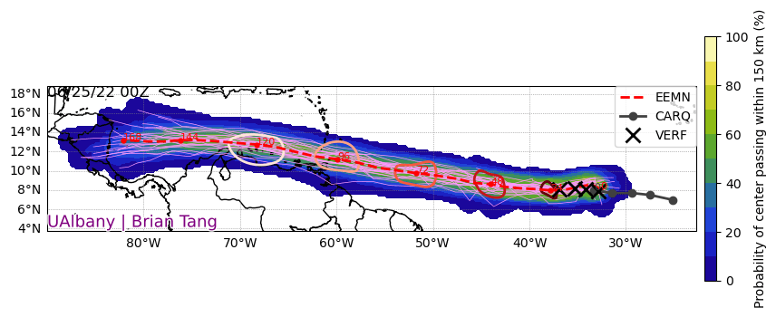
Over the last three to four days, there has been remarkable consistency in the timing and location of where this disturbance will track. Tonight, while the general modeled location remains slightly adjusted to the south, with the center now tracking over northeastern Trinidad, there is still a notable spread on Invest 94L’s intensity.
However, with compact systems like Invest 94L, subtle changes in the track could mean a direct hit or a complete miss.
Timing
The top three models for tropical cyclone development: the European Center for Medium-range Weather Forecasting (ECMWF) global forecast model, the National Oceanic and Atmospheric Administration (NOAA) Global Forecast System (GFS) model, and the United Kingdom Met Office’s global forecast model (UKMET) has the center of this disturbance tracking:
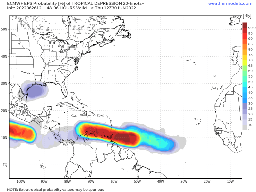
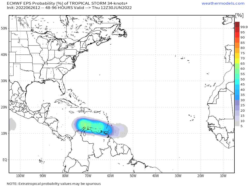
- 10:00 AM – 5:00 PM Tuesday: Outer bands moving across Barbados, Tobago first, then across Trinidad.
- 5:00 PM Tuesday – 5:00 AM Wednesday: Center of disturbance tracking in the vicinity of T&T.
- 5:00 AM – 11:00 AM Wednesday: Center of disturbance moving into the Caribbean Sea between the Paria Peninsula and Grenada.
- The remainder of Wednesday: Trailing showers and thunderstorms continue to affect T&T
The latest model runs have had some notable changes in the timing. While the general motion remains the same – peak winds and rains moving through the Windwards Tuesday night into Wednesday morning, models now show outer bands reaching earlier with lingering showers and thunderstorms persisting longer. slowed down the passage of Invest 94L’s eventual system as it moves across T&T. These changes may allow for overall higher rainfall totals across T&T and the Windwards.
While the general timing of this system is fairly well established across top models, there is still uncertainty for systems that have not yet formed.
Location
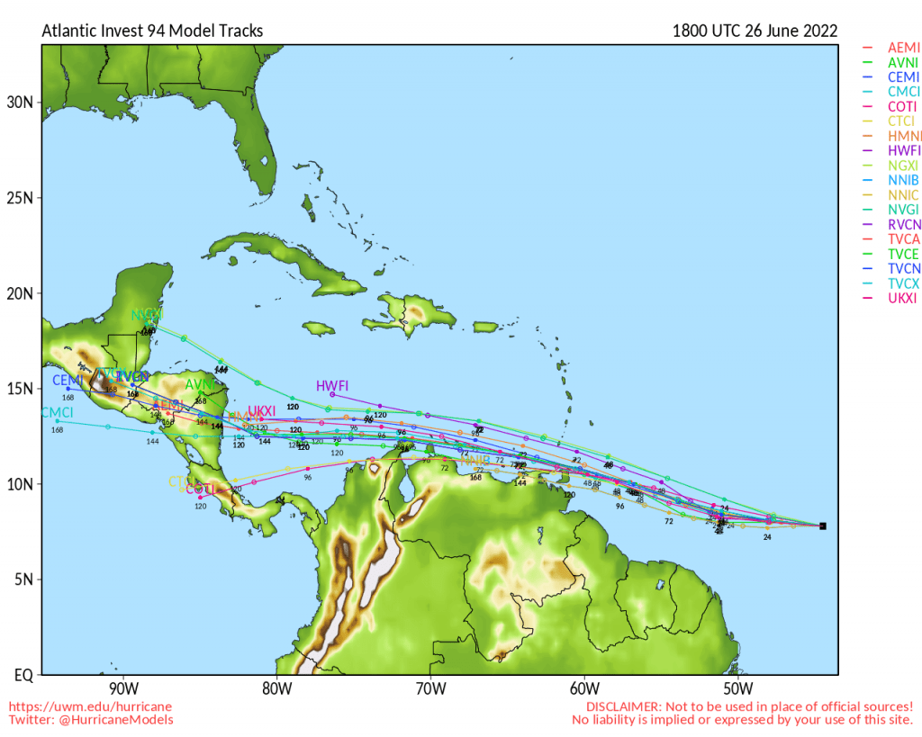
A large high-pressure ridge anchored in the far North Atlantic Ocean will continue to steer Invest 94L west to the west-northwest over the next 48 to 72 hours.
Given the compact size of the disturbance, subtle changes in the eventual track of the low-level center could result in T&T missing the strongest winds and rains.
The latest 18Z runs on Sunday evening show a slight southward adjustment, with the center of the system tracking across northern Trinidad, with the northernmost tracks moving slightly north of Tobago.
The ECMWF has a weak low-pressure system tracking between Trinidad and Tobago after midnight Tuesday into Wednesday. Meanwhile, the GFS shows a weaker and more disorganized area of low pressure moving across Trinidad from the southeast to the northwest early Wednesday morning. The UKMET model is between the GFS and ECMWF, showing a broader area of low pressure marginally strengthening as it moves between T&T, or across northeastern Trinidad. Other tropical models show similar solutions between the GFS and ECMWF locations.
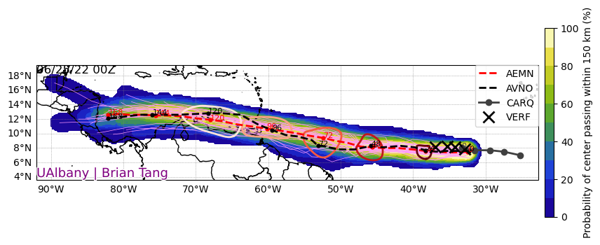
The latest runs of the GFS model continue to show a more southerly track. Still, this southerly bias seems to be a shortcoming of the model, as it tends to overdo the influence of convection over South America, tugging systems further south than expected. The ECWMF, on the other hand, has been closely tracking the actual motion of Invest 94L since the system was designated an Invest.
Given this system is forecast to generally remain compact with the strongest winds north of the low-pressure center, a track across or north of Tobago would keep elevated sustained winds and gusts north of Trinidad and Tobago, primarily impacting other Windward Islands like Grenada, the Grenadines, St. Vincent, and even Barbados.
When systems move north of the country, south to north wind flow takes shape across Trinidad and Tobago, leading to flooding rainfall along the south-facing slopes of mountain ranges across the country.
Intensity
Regardless of development and whether it is classified as a tropical depression or tropical storm, this disturbance is forecast to have strong sustained winds north of its circulation while still bringing significant rainfall accumulations to T&T and the Windwards south of St. Lucia late Tuesday into Wednesday.
What is required for a tropical cyclone to be classified?
A non-frontal low-pressure system of synoptic scale developing over warm waters having organized deep convection and a maximum sustained winds of 34 knots (63 KM/H) or greater extending more than halfway around near the center and persisting for at least six hours. There also needs to be a closed surface wind circulation around a well-defined center. Systems can also be given tropical depression status if it meets the tropical cyclone definition but maximum sustained winds are less than 34 knots or 63 KM/H.
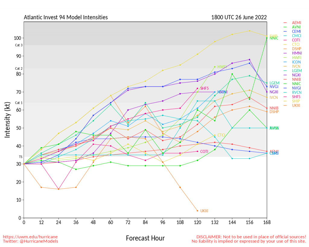
As of 18Z Sunday, June 26th, 2022, most models show a system of tropical storm strength as it moves across T&T (at the 60-hour mark).
As the system tracks near or over T&T, among the top three operational runs of the GFS, ECMWF, and UKMET, forecast models show sustained winds between 35-65 KM/H with wind gusts to 95 KM/H. However, the strongest winds are still appearing to remain north of the country, affecting northeastern Tobago, and Grenada to Martinique.
As of June 26th, 2022, sustained winds up to 40 KM/H are possible across Trinidad and gusts up to 60 KM/H, while in Tobago, sustained winds up to 55 KM/H are possible with gusts to 75 KM/H.
While gusty winds are possible, the main hazard, based on model data, is forecast to be heavy rainfall. Over the next five days, through Friday, July 1st, 2022, between 75 and 125 millimeters of rainfall is forecast across T&T, with isolated totals in excess of 200 millimeters. Similar rainfall totals between 25 and 75 millimeters, with localized higher totals, are forecast across Grenada, St. Vincent and the Grenadines, Barbados, and St. Lucia.
The Bottom Line
At this time, Trinidad and Tobago is not under any tropical storm watch or warning. However, this may change over the next 24-36 hours. Now is the time to begin finalizing preparations ahead of a multi-day heavy rainfall event. If you live in a flood-prone area, know your risk and prepare accordingly with sandbags and other flood barriers. If you live in an area where landslides are prone, know what to do in the event
Regardless of development, a strong tropical wave is forecast to move across Trinidad and Tobago on Tuesday night into Wednesday. Though strong winds remain a possibility, particularly for Tobago, forecast models continue to keep hazardous winds north of the country, resulting in mainly a heavy rainfall event for both islands.
With Tropical Wave 11 on Sunday into Monday, Invest 94L on Tuesday into Wednesday, and Tropical Wave 13 on Friday into Saturday, all while the ITCZ lingers in the area, heavy rainfall will persist through the week. Street/flash flooding will be likely, with elevated chances for riverine flooding, particularly by Wednesday. Pay attention to the latest forecasts for more details.
Here are a couple of things you can do:
- Stock your emergency kit
- Clean your surroundings and gutterings
- Secure light or loose objects outdoors
- If your roof is unsecured, purchase and install hurricane straps
- Clear larger trees near your home
- Ensure you have batteries and battery packs for your flashlights, radios, and mobile devices
- Ensure you have sufficient gas for gas-powered stoves and vehicles
- Ensure you have adequate dry foods and water to rally through an extended power outage (generally, the rule of thumb is 72 hours).
- Stock up on candles and mosquito repellant.
- Ensure you have alternative means of communication (like a battery-powered radio) if the internet or television goes down.
- Have a trusted source of information for the latest news before, during, and after a storm.


