


Seas are forecast to remain near normal for this time of year over the next week. Low-level winds are forecast to remain moderate, with no long-period swells forecast.
However. a moderate to high concentration surge of Saharan Dust is set to reduce horizontal visibility offshore, creating unsafe conditions for smaller crafts by the weekend.
There are no marine alerts, watches, or warnings in effect from the Trinidad and Tobago Meteorological Service at this time.
Seas Forecast For Trinidad and Tobago
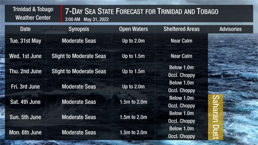
In sheltered areas, waves are forecast to be near calm through the next 48 hours. By Thursday, through the remainder of the forecast period, seas in sheltered areas are forecast to be below 1.0 meters with occasionally choppy conditions due to forecast heavy showers or thunderstorm activity.
Winds are forecast to be moderate to fresh through the next several days, with sustained winds up to 20 knots from the southeast to northeast and gusts as high as 25 knots.
Generally, seas in open waters will remain moderate through the next seven days. In open waters, waves are forecast to generally be up to 2.0 meters through the week.
As early as late Friday, June 3rd, 2022, a surge of Saharan Dust will begin to affect T&T. Dust haze will gradually diminish into the weekend. Still, horizontal visibility may dip as low as 7 kilometers outside of shower or thunderstorm activity.


