


Earthquakes cannot be predicted based on current research and technology.
Earthquake prediction is a branch of seismology focused on predicting an exact time, location, and magnitude of an earthquake within a specific location. Earthquake forecasting is the probability of the general seismic hazard of an area, including the frequency and magnitude of earthquakes in an area over years or decades.
Both forecasting and prediction differ from earthquake warning systems, which detect initial seismic waves (P-Waves) and provide real-time warning to regions that might be affected.
Earthquake Prediction
Based on current research and technology, earthquakes cannot be predicted. This may go against what the online “psychics” or “prophets” have been repeating, but any predictions made by these persons tend to have no scientific basis.
In fact, these “predictions” tend to be so broad, that it may seem as if they’re always correct.
For example, if someone says there will be a large earthquake in the Eastern Caribbean, an area that experiences 2,200 earthquakes annually, obviously, they will be correct. Similarly, if someone says Kick’em Jenny will experience unrest this year, they will also be correct, as Kick’em Jenny has been in a state of elevated seismicity for the better part of the last decade.
There have been several attempts to predict an earthquake, and it is an area of active scientific research. However, to date, this research has not been fruitful.
An earthquake prediction (a deterministic prediction) must define the following criteria:
- An exact date and time
- A precise and accurate location
- The magnitude
There have been two general scientific approaches to predicting earthquakes: identifying distinctive precursors to earthquakes or identifying some geophysical trend or pattern in seismicity that might precede a large earthquake. (Predicting Earthquakes: A Scientific and Technical Evaluation – with Implications for Society).
Neither of these approaches can define all of the three criteria.
Earthquake Precursors (Animal Behaviour etc.)
An earthquake precursor is an anomalous phenomenon that might give an adequate warning of an impending earthquake. Examples of these are animal behavior, changes in seismic wave characteristics, or electromagnetic anomalies.
Typically, people tend to reference the behavior of animals if they’re referencing an earthquake precursor. In cases where animals display unusual behavior some tens of seconds before a quake, it has been suggested they are responding to the P-wave. These travel through the ground is about twice as fast as the S-waves that cause the most severe shaking. P-Waves the earthquake itself — that has already happened — but only the imminent arrival of the more destructive S-waves. This is the basis for an earthquake warning system.
Studies have been done to prove animal behavior as a method of warning about an impending quake. Ultimately, animal behavior was not reliable in warning of an earthquake in the numerous studies conducted.
There are several other alleged means of attempting to predict an earthquake, which have been outlined here. However, and reiterating, based on current research and technology, earthquakes cannot be predicted.
Earthquake Forecasting
While earthquakes cannot be predicted, several scientific strides have been made to forecast earthquakes.
Geoscientists can identify particular areas of risk and, if there is sufficient information, make probabilistic forecasts about the likelihood of earthquakes happening in a specified area over a specified period. These forecasts are based on data gathered through global seismic monitoring networks, high-density local monitoring in known risk areas, geological fieldwork, and historical records.
Forecasts are improved as our theoretical understanding of earthquakes grows, and geological models are tested against observation. Long-term forecasts (years to decades) are currently much more reliable than short to medium-term forecasts (days to months).
It is common to see phrases such as there is an XX% chance of a magnitude X occurring within X days/months/years with earthquake forecasts. The USGS has recently started producing aftershock forecasts for large earthquakes occurring within their area of responsibility, such as the M7.1 earthquake near Anchorage, Alaska, in November 2018.
Earthquake forecasts are usually based on the three following theories:
Geophysical Trends & Patterns
Geophysical trends and patterns are routinely used in earthquake forecasting as it tends to lean more into using probabilities of an earthquake occurring. These trends are complex and utilize many variables and advanced statistical techniques, including elastic rebound, characteristic earthquakes, seismic gaps, and seismicity patterns.
The latter three are used routinely in determining the seismic hazard of the Eastern Caribbean.
Characteristic Earthquakes
Characteristic earthquakes postulate that some earthquakes are generally constrained to distinct segments. Since the lengths and other properties of the segments are fixed, earthquakes that rupture the entire fault should have similar characteristics. These include the maximum magnitude (which is limited by the length of the rupture) and the amount of accumulated strain needed to rupture the fault segment. These maximum magnitude scenarios are annually used in the Caribbean-wide tsunami drills, CARIBE-WAVE.
Since continuous plate motions cause the strain to accumulate steadily, seismic activity on a given segment should be dominated by earthquakes of similar characteristics that recur at somewhat regular intervals.
This ties into seismicity patterns. Identifying these characteristic earthquakes and timing their recurrence rate (or return period) should inform us about the next rupture for a given fault segment. This is the approach generally used in earthquake forecasting.
Seismicity Patterns
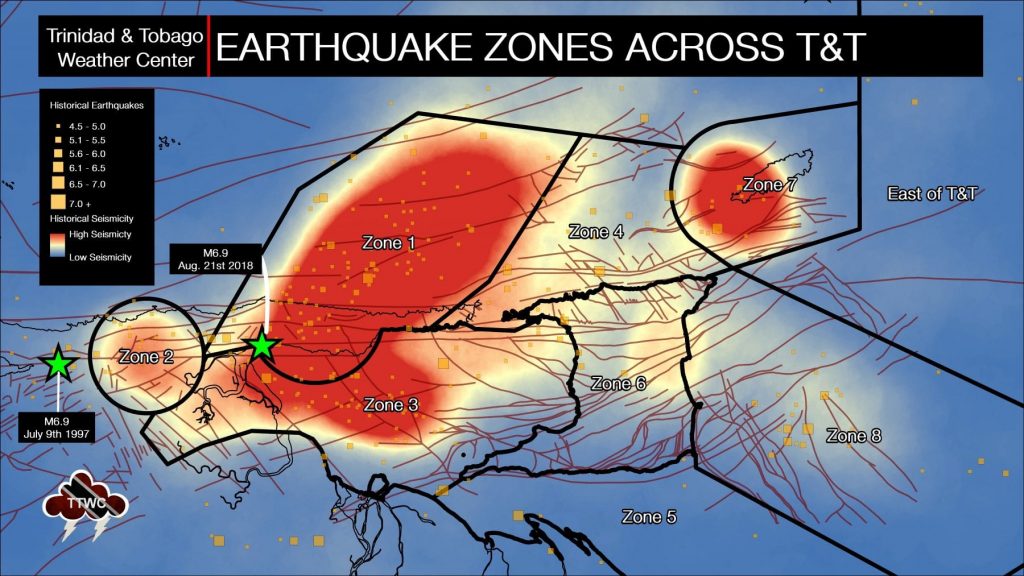
Trinidad and Tobago and the surrounding region are very seismically active areas. Across the Eastern Caribbean, over 2,200 earthquakes are recorded annually. Since 1990, the U.W.I. SRC records an annual average of 280 earthquakes in the Trinidad and Tobago region (area bounded by 9.5°- 11.5°N & 59.5°W – 63.5°W). Of these 280 quakes, 50 of these seismic events are, on average, above magnitude 3.5. This means, on average, we expect to see approximately 23-24 earthquakes per month, with 4-5 earthquakes larger than M3.5.
On average, the Eastern Caribbean has seen a pattern of major (M7.0-M7.9) quakes every 20 to 30 years. That pattern has stayed true. The last major (M7.0-7.9) quake occurred north of Martinique in 2007.
Seismic Gaps
A combination of seismicity patterns, characteristic earthquakes, and geophysical studies of regions can determine areas where it is uncharacteristically quiet concerning earthquake activity.
A seismic gap is a segment of an active fault known to produce significant earthquakes that has not slipped in an unusually long time compared with other segments along the same structure. There is a hypothesis or theory that states that over long periods, the displacement on any segment must be equal to that experienced by all the other parts of the fault. Therefore, any large and longstanding gap is considered the fault segment most likely to suffer future earthquakes.
This is the case in parts of the Eastern Caribbean, most notably, south of Martinique.
By using seismic gaps and other information, seismologists and geoscientists can calculate and determine probabilities for the likelihood of seismic events and effectively create an earthquake forecast.
FAQ on Earthquake Predictions & Forecasting
Can the weather cause earthquakes?
Weather does not affect nor cause seismic events in Trinidad and Tobago. When hot weather occurs, one of the most common comments is that it is “earthquake weather?”
It’s a fairly common misconception with origins as early as the 4th century B.C. Aristotle proposed that earthquakes were caused by winds trapped in subterranean caves. Small tremors were thought to have been caused by air pushing on the cavern roofs and large ones by the air breaking the surface.
This theory leads to a belief in earthquake weather, that because a large amount of air was trapped underground, the weather would be hot and calm before an earthquake. A later theory stated that earthquakes occurred in calm, cloudy conditions and were usually preceded by strong winds, fireballs, and meteors.
There is no such thing as “earthquake weather.” Statistically, there is approximately an equal distribution of earthquakes in cold weather, hot weather, rainy weather, etc.
Very large low-pressure changes associated with major storm systems (typhoons, hurricanes, etc.) are known to trigger episodes of fault slip (slow earthquakes) in the Earth’s crust. They may also play a role in triggering some damaging earthquakes. However, the numbers are small and are not statistically significant.
Water can remove sediment or infiltrate the ground and increase or decrease the overburden pressures. This change in ground pressure can trigger minor seismic activity. Excessive rainfall, not hot weather, can also contribute to minor seismic activity.
Earthquake weather does not exist, and hot temperatures do not cause earthquakes.
Source: USGS, Dr. Malcom Johnston
Can people sense an earthquake before it occurs?
There is no scientific explanation for the symptoms some people claim to have preceding an earthquake, and more often than not, there is no earthquake following the symptoms.
Source: USGS
Do Solar Flares, Magnetic Storms, or Other Space Weather Cause Earthquakes?
“Space Weather” tends to affect primarily technological systems such as GPS and electricity grids but falls short of affecting seismic activity. There is no causal relationship between space weather and earthquakes – meaning space weather does not cause earthquakes.
Throughout the Sun’s 11-year variable cycle, the occurrence of flares and magnetic storms waxes and wanes, but earthquakes occur without any such 11-year variability. Since earthquakes are driven by processes in the Earth’s interior, they would occur even if solar flares and magnetic storms were to cease somehow occurring.
Any seismic event occurring during one of these solar flares or magnetic storms is coincidental and not related.
Source: USGS
Does the Moon Cause Earthquakes?
No, the moon, its phases, and even supermoons do not cause earthquakes, as it is currently understood.
The popular belief is that the full moon or a supermoon has the strongest tidal pull – which allegedly places more stress on the Earth’s crust and increases the chances that a fault may slip. Another (incorrect) theory is that somehow, a supermoon or full moon slows the rotation of the Earth, inexplicably triggering seismic activity.
A seismologist at the United States Geological Survey, Susan Hough, examined whether large (<M8.0) earthquakes occur during particular lunar phases, dating back to the 1600s. She found that the occurrence of a quake has no relationship to the position of the moon or sun relative to the earth.
Like “earthquake weather,” any quakes that occur during these periods are likely coincidental.
Some scientists believe that the increased tidal forces could be the proverbial straw that breaks the camel’s back in the case of smaller events. However, because the modulation of forces is so minuscule, there would be no practical use for prediction.
More information can be found at length from the Smithsonian.
Why can’t earthquakes be predicted?
Most earthquakes result from the sudden release of stress in the earth’s crust, which has built up gradually due to tectonic movement, usually along an existing geological fault. The crust’s response to changing stress is not linear (that is, it is not directly proportional, making the prediction of behavior more difficult), and is dependent on the crust’s complex and highly variable geology. As a result, it is very difficult to build accurate simulations that allow for earthquake prediction. Laboratory experiments which attempt to reproduce these physical processes can add to our understanding, but cannot accurately reflect the complexities of real-world geological settings. A further difficulty is that earthquakes originate beneath the ground, often many kilometers down, so data gathering depends on remote observation techniques and measuring effects at the surface. Even measuring the prevailing stress in the crust is challenging, as it requires drilling several kilometers into the ground. Some have suggested that other factors such as increased levels of radon, changes in the water table, variation in the electrical properties of rock or the behavior of animals may be diagnostic precursors. These have been the subject of research over several decades, and none has been found to be a good indicator, as they can all occur without being followed by an earthquake.
The Geological Society
Protecting Yourself From The Next Big Earthquake
Since earthquakes cannot be predicted and there is no planned early warning system for earthquakes, the most we can do as individuals is prepare.
Trinidad and Tobago and the remainder of the Eastern Caribbean exist along major plate boundaries. With this comes earthquakes – large and small. Earthquakes occur every day throughout the Eastern Caribbean. They have done so for centuries before and will continue to do so for centuries.
Read More

In our region, earthquakes can strike at any time and any place, so it is important to know how to keep yourself safe when one strikes.


