


A well-defined tropical wave – Tropical Wave 16 – has been designated as Invest 95L and has a medium chance of tropical cyclone formation over the next seven days. Forecast models show the development of this system over the next several days as it generally moves westward.
However, at this point, without a well-developed system, forecast models are guessing where the center will develop, and ultimately, confidence in both the location and intensity of impacts remains uncertain.
Based on the forecast path, this system is forecast to move north of Trinidad and Tobago. The heaviest rains and strongest winds will occur between Tobago and St. Lucia, moving across Grenada, the Grenadines, and St. Vincent.
What you need to know
— What has happened: A robust tropical wave, designated as Invest 95L, is being monitored for tropical cyclone formation in the Main Development Region of the Tropical Atlantic, approximately 3,300 kilometers east of Trinidad and Tobago.
— Where is it forecast to move: Forecast models have consistently shown Invest 95L and the eventual tropical cyclone remaining north of Trinidad and Tobago, moving across the southern Windwards, based on model runs over the last 24 hours. This system is likely to impact the region from Sunday night through Tuesday morning
— The Intensity & Impacts: Forecast models indicate this disturbance will likely be a tropical storm or hurricane as it moves through the Windwards. However, it is still too soon to pinpoint exact impacts, but increased cloudiness, showers and thunderstorms, strong winds and gusts, and agitated seas are likely across the southern half of the Lesser Antilles, including T&T.
— Latest from officials: Across the island chain, there are no alerts, watches, or warnings. However, several meteorological offices have issued statements on the system.
The latest

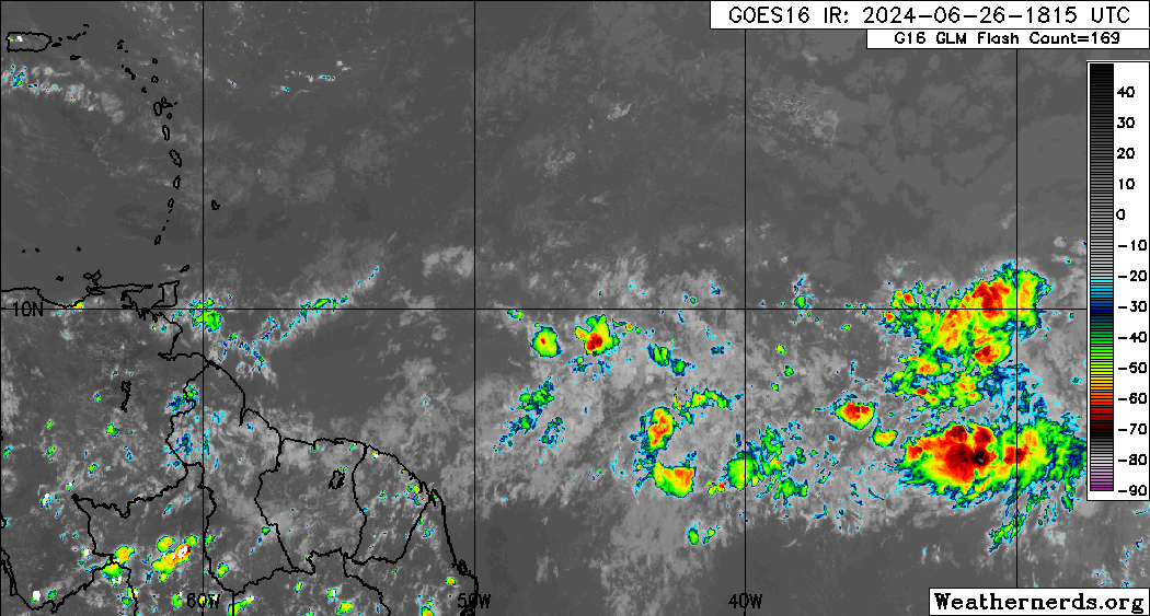
At 8:00 PM Wednesday, June 26th, 2024, the approximate center of Invest 95L’s low-pressure area was located along 31.1°W, approximately 3,300 kilometers east of Trinidad and Tobago.
According to the National Hurricane Center’s (NHC) 8:00 PM Tropical Weather Outlook, “Satellite images indicate that a tropical wave located several hundred miles southwest of the Cabo Verde Islands has become better organized since yesterday with a more concentrated area of thunderstorms. Environmental conditions are forecast to be unusually conducive for late June across the central and western tropical Atlantic, and further development of this system is anticipated.”
They add, “A tropical depression or tropical storm could form this weekend several hundred miles east of the Windward Islands while the system moves westward at 15 to 20 mph.”
The NHC has given Invest 95L a low chance of development over the next 48 hours, at 30%, and a medium chance, at 60%, of development over the next seven days.
This area of disturbed weather is producing a cluster of cloudiness with scattered showers and thunderstorms. It is located in a pocket of favorable upper-level divergence and low-level convergence, under an area of light wind shear. Sea surface temperatures are between 27°C and 29°C, and atmospheric moisture is anomalously high.
What is an Invest?
In Meteorology, an INVEST (short for an investigative area, also called an area of interest) is a designated area of disturbed weather monitored for potential tropical cyclone formation.
In the Atlantic Basin, these INVESTs are designated by the United States National Hurricane Center, numbered from 90 to 99, followed by the suffix L. These suffixes change for each basin, with “E” and “C” in the Eastern and Central Pacific basins (respectively) or “W” in the Western Pacific basin. Numbers are rotated within the season and are re-used as necessary (the subsequent INVEST after 99 would be numbered 90).
According to the National Hurricane Center, designating a tropical weather system as an INVEST allows for the collection of specialized data sets and computer model guidance on the area of interest. This data collection and processing are shown on several government and academic websites for analysis.
The designation of a system as an INVEST does not necessarily correspond to any particular likelihood of the development of the system into a tropical cyclone.
Where is it going?

Forecast models show Invest 95L being steered west over the next several days as it ridges the periphery of a large subtropical ridge anchored in the North Atlantic Ocean, taking the system near and even across the Windwards on Monday, July 1st, 2024.
Over the last 24 or so hours, Invest 95L has maintained a generally west-to-west-northwestward path, but once this system consolidates, as with most tropical cyclones east of the Lesser Antilles, it begins to take on a slightly more west-northwest path.
As it stands on Wednesday, Invest 95L and the eventual tropical cyclone from this disturbance may pose a threat north of Tobago and across the southern and central Windwards, from Grenada to Martinique, with strong wind gusts possible across the northern Windwards. There are no alerts, watches, or warnings in effect for any islands across the Lesser Antilles, but interests in the region should pay close attention to the latest information coming out of their respective local meteorological offices.
It is too soon to tell where this system may track after it crosses the Windward Islands, but the general consensus is that it will continue west to west-northwest through the Caribbean Sea next week.
How strong could it get?

Based on the current forecast tracks, models move Invest 95L through an unusually favorable environment for this time of year.
The tropical wave is embedded within the monsoon trough, an area in the Atlantic similar to the Intertropical Convergence Zone, where there is enhanced storminess and background spin. For the next few days, this disturbance will remain attached to the monsoon trough as it moves westward, but it will need to detach itself from the monsoon trough to begin intensification.
This system will continue moving far south of the dry Saharan Dust and stronger wind shear across the North Atlantic, with a generally favorable upper-level environment.
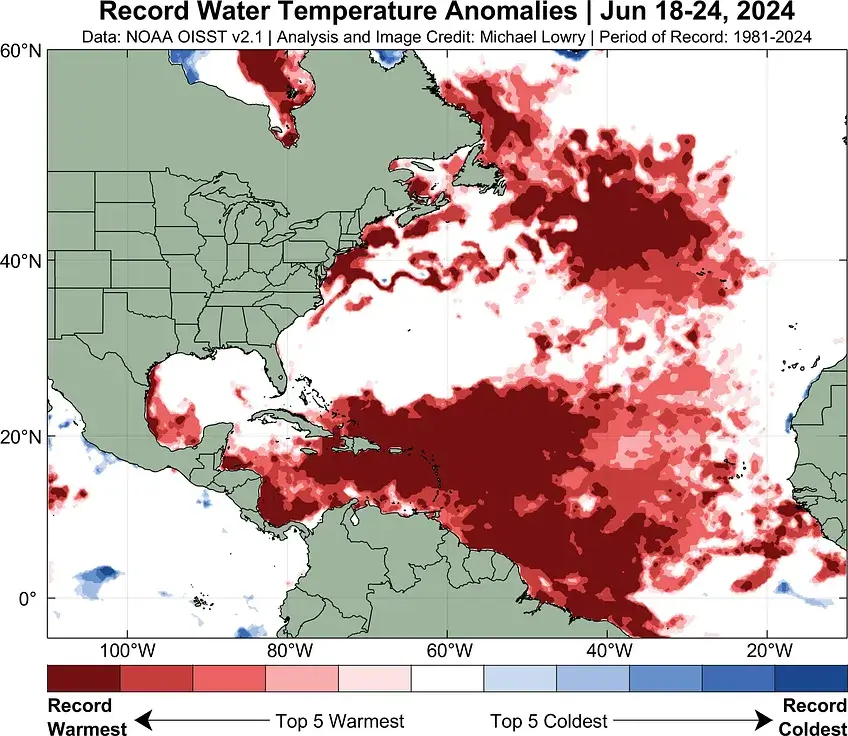
With anomalous and record-warm sea surface temperatures and a generally conducive environment for strengthening, this system is likely to develop, becoming a tropical storm by the weekend, and potentially could make a run at hurricane status.
After this system tracks across the Windward Islands, it is too soon to tell how strong this low-pressure system will remain as the Eastern Caribbean Sea is typically a graveyard for storms.
What does this mean for the Lesser Antilles?
For the southern and central Lesser Antilles, tropical cyclone preparedness plans should be reviewed. If this system consolidates over the next 48 hours, some islands may be placed under a tropical storm watch from this weekend. There is an increasing risk of heavy rainfall that will produce floods, landslides, and mudslides, as well as strong winds and gusts that can produce wind damage and rough seas.
Note that impacts will be highly dependent on the size and eventual intensity of the disturbance, which remain uncertain at this time.
Wind
Based on the latest guidance, tropical-storm-force wind gusts and sustained winds (above 34 knots, 39 MPH, 63 KM/H) are forecast to primarily affect the Windwards. This includes from Grenada through Martinique, with isolated strong gusts possible from Dominica to Angitua and St. Kitts in isolated heavy showers or thunderstorms. However, this is dependent on the track of the core of this eventual system. It should be noted that with systems that have not yet formed, there is a larger-than-usual uncertainty in both the track and intensity forecast.
For T&T, the pressure gradient between the low-pressure system north of the Lesser Antilles and a high-pressure system over northern South America will lead to strong low-level southeasterly winds across the area from Monday through Tuesday morning. These winds can reach the surface in showers or thunderstorms. Wind gusts exceeding 45 KM/H are likely during this period, and gusts exceeding 55 KM/H are possible.
Rainfall

The highest rainfall accumulations are forecast to occur between Grenada and St, Vincent and the Grenadines, with rainfall totals through Wednesday, July 3rd, 2024, ranging between 100 and 150 millimeters (4-6 inches) with isolated totals up to 250 millimeters (10 inches).
Across the remainder of the southern and central Windwards, including Barbados, between 50 and 100 millimeters (2-4 inches) of rainfall is likely, with isolated totals up to 150 millimeters favoring windward (eastern) coastlines.
For Trinidad and Tobago, between 50 and 100 millimeters (2-4 inches) of rainfall is forecast, with isolated totals up to 125 millimeters. Note that if feeder band activity persists across Trinidad and/or Tobago, locally higher totals are possible.
For the Leewards, rainfall totals are forecast to be between 25 and 50 millimeters (1-2 inches), with isolated totals of up to 100 millimeters, favoring southern and eastern coastlines.
Seas and Storm Surge
There is still substantial uncertainty on where the strongest winds from Invest 95L are forecast to track, which highly influences the sea’s forecast. Based on the latest model guidance, waves south of Guadeloupe, and north of Tobago are forecast to be above 3.5 meters. Peak waves are forecast to occur north of Tobago and south of Martinique, with peak heights ranging from 4.5 meters to 10 meters in open waters.
For T&T, rough seas are likely on Monday and Tuesday, mainly along the country’s eastern and northern offshore areas, with waves 2.5 and 5.0 meters in open waters.
Again, this is based on current track and intensity guidance, which can change in the coming days.
For Trinidad and Tobago
For Trinidad and Tobago, given this system is forecast to generally remain north of the country, feeder band activity poses the most risk, with locally heavy rain, accompanied by potentially damaging wind gusts. Stronger southerly winds may also lead to isolated thunderstorms being enhanced by topography, and with near-calm to light winds mainly on Monday and Tuesday and with clockwise turning winds through the atmosphere, the potential for funnel clouds will also exist. Rough seas are also likely, mainly in northern and eastern coastal waters.
Pay close attention to official forecasts in the coming hours and days from your respective authorities. For Trinidad and Tobago, official forecasts and early warnings come from the Trinidad and Tobago Meteorological Service.
If this system forms, it will be called Beryl.


