


What you need to know:
— The 2022 Dry Season has officially started, according to the Trinidad and Tobago Meteorological Service.
— Compared to last year’s record-breaking wetter-than-usual dry season, the 2022 Dry Season is likely to produce less rainfall than usual overall, with below-average totals most likely.
Likely Impacts:
— Less rainfall than usual will reduce surface water flows and rain-fed water availability;
— An increase in surface dryness as the season progresses will increase the potential for bush/grass/forest and landfill fires, which can deteriorate the air quality and stress persons with sensitive respiratory conditions.
The Trinidad and Tobago Meteorological Service is officially declaring the start of the 2022 Dry Season.
Ongoing climatic patterns/features, including the dominance of upper-level westerly winds over the region, an intensified North Atlantic Sub-Tropical High-Pressure system that has expanded its reaches southward and deeper into the atmosphere, compared to two (2) weeks ago, along with a strengthened trade-wind inversion, which serves to limit deep clouds development, are present. Together, this configuration signals that the region has transitioned to its drier state, which is generally manifested by reduced moisture, increased stability, fewer deep clouds, less frequent rainfall, cooler temperatures, and stronger surface winds.
The 2022 Dry Season outlook indicates slightly drier than usual conditions are favored, with below-average rainfall most likely, but February to April is likely to be the driest period. The outlook also calls for warmer than average day and night temperatures, but a few relatively chilly nights are expected, when temperatures will fall below 20.0°C due to relatively colder air being funneled into the region from the sub-tropical high-pressure system and migrating weather systems from colder latitudes. The country is also likely to see an increase in the frequency of hazardous sea conditions, Saharan dust-haze events, and environmental conditions that increase bush/grass/forest and landfill fires.
The Met Office advises the public to conserve, store, and manage water sustainably. During the dry season, it is highly recommended that the public refrain from burning rubbish in grassy or forested areas. Relevant agencies and ministries are advised to take measures to mitigate the potential impacts.
What to expect?
Overall, the 2022 Dry Season is likely to be drier than average for Trinidad and Tobago, with accumulated rainfall totals likely to be below normal. However, the season is still expected to produce a few moderately wet days with typical dry season weather.

On average, the country receives 113 dry days (days with less than 1 mm of rainfall) in the dry season. The country is likely to get more than the average number of dry days (109) during the 2022 Dry Season.
The country usually receives 3 to 8 7-day dry spells and 1 to 5, 10-day dry spells in the dry season. For the 2022 dry season, there is a 68% probability for 4 to 9 7-day dry spells and 2 to 6 10-day dry spells.
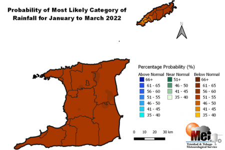
The Dry Season outlook shows percentages of rainfall totals between 46% and 90% across both islands. The majority of Trinidad is likely to get percentages of average seasonal rainfall that are less than 76% of average. The largest percentage of average seasonal rainfall ranges between 76% and 90% and is confined to portions of northeast and northwest Trinidad. Both the southwestern and northeastern ends of Tobago are likely to get a percentage of average totals less than 76%. Elsewhere, values are likely to be between 76% and 90%;
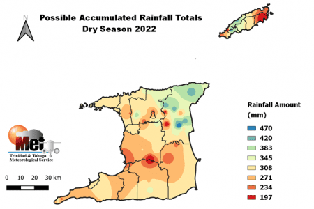
Dry season accumulated rainfall totals for 2022 in Trinidad are likely to be highest in north-eastern areas in the vicinity of Valencia, Sangre Grande, North Oropouche, Toco, and surrounding environs, where totals could range between 345 mm and 470 mm. The lowest dry season totals in Trinidad are likely to occur in southern areas, with possible totals between 300 and 400 mm. In Tobago, seasonal rainfall totals are likely to range between 200 and 350 mm with the lowest total likely in the windward part of the island near Kings Bay and Speyside.
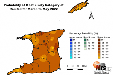
March is typically the driest month in the dry season. The March to May 2022 rainfall outlook indicates that below-normal rainfall is likely, but with reduced probabilities.
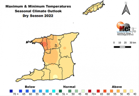
Both JFM and the 2022 Dry Season temperature outlooks show elevated odds of above-normal seasonal mean temperatures.
JFM and Dry season maximum and minimum temperatures are also likely to be warmer than average across Trinidad and Tobago, with a greater than 50% chance of this occurring. The greatest odds for warmer-than-average nights and warmer-than-average days are located in the cities, most urban areas, and built-up areas.
Maximum temperatures are likely to peak near 33.5°C during the Dry Season, which is favored to occur between April and May. There are elevated odds for at least three very cold nights between January and February when the minimum temperature can fall below 20.0°C.
What does this mean for you?
- Deficiencies in rainfall amounts during the dry season have negative implications for water resource management.
- Expect reduced recharge rates, slower and lower than usual stream flows and water levels.
- The potential exists for an increase in the need to collect and store water in containers. This can increase breeding areas for mosquitoes.
- Expect increased browning of weeds, grass, bush, and some forest species as the season progresses.
- Drying will increase bush, forest, and landfill fire potential as the season progresses, especially during late February and March.
- Reduced air quality is likely during bush, grass, forest, and landfill fires. This can negatively affect persons with existing respiratory and other ailments.
- Possibility of increased disruption in marine activities due to episodes of rough seas.
- Warmer-than-usual temperatures can lead to warmer-than-usual water temperatures, which are particularly important for the health of aquaponics fish, plants, and hydroponic plants.
- Water temperatures much warmer than 30.0°C can affect warm-water fishes such as tilapia.


